By the numbers, the D.C. region’s weather in 2022 wasn’t outrageous, but a few raucous atmospheric outbursts presented both drama and danger.

By the numbers, the D.C. region’s weather in 2022 wasn’t outrageous, but a few raucous atmospheric outbursts presented both drama and danger.
 1/6
1/6
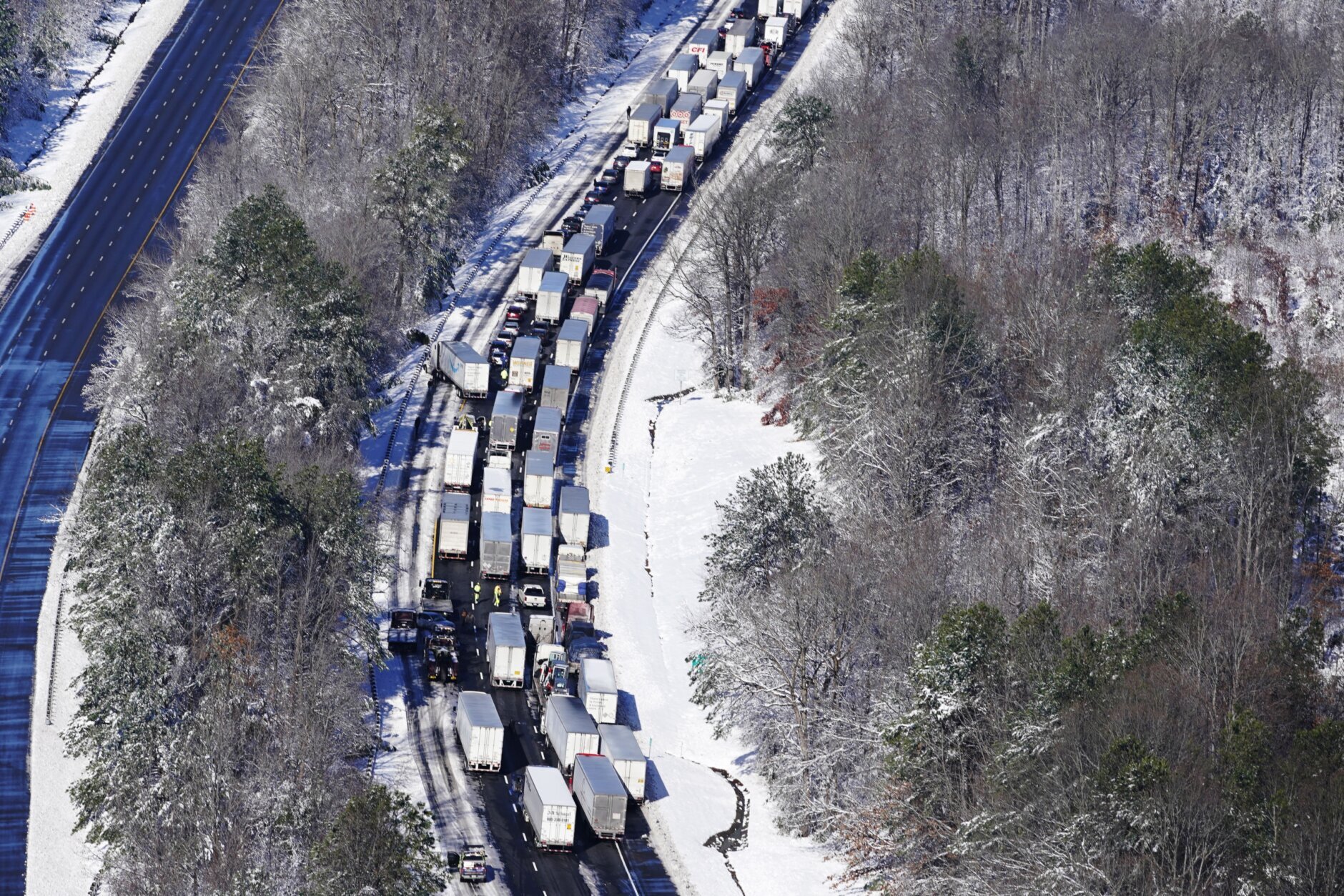
The most fateful weather event of 2022 will be remembered not for its meteorological ranking but for its disastrous impact on traffic.
A well-forecast snowstorm on Jan. 3 produced a broad swath of foot-deep snow across Stafford County, Spotsylvania County and Fredericksburg in Virginia. About half a foot fell near the Capital Beltway, with lesser amounts to the north. It was the kind of winter storm that passes through the area once every three to five years.
In the face of Winter Storm Warnings, too many people decided to drive that Monday morning and many of them incurred hours-long traffic delays. Traffic seized on the snow-covered Beltway near the Woodrow Wilson Bridge. Some drivers idled on Route 50 near Annapolis, Maryland, for more than four hours.
The words “disaster” and “nightmare” are often inappropriately used describe to commonplace traffic backups, but the agony and potentially life-threatening conditions that drivers endured on Jan. 3 and 4 were truly nightmarish south of Washington.
On Interstate 95 in northern Virginia, a volatile combination of heavy New Year’s weekend traffic and extreme snowfall rates led to one of the worst traffic disasters in recent history. One by one, drivers of big trucks and small cars began losing traction and blocking lanes.
Snow, falling at rates exceeding two inches per hour, rapidly piled up between large clusters of disabled vehicles, with long segments of the highway becoming impassable between Thornburg and Garrisonville.
The result was unprecedented — far worse than even the harrowing traffic tales told after notorious snowstorms on Jan. 26, 2011 and March 9, 1999. Some drivers and passengers were marooned on I-95 for more than 24 hours, forced to spend the night on the dark highway without food, water or a bathroom. A 40 mile segment of I-95 was closed for nearly two days for the removal of disabled vehicles and ice.
The Virginia Department of Emergency Management, Virginia Department of Transportation and the Virginia State Police were criticized for their delayed response, poor coordination and “broader lack of situational awareness” in an after-action report. Virginia’s inspector general revealed additional glaring missteps in a 29-page audit.
The shortcomings in the Commonwealth’s response exacerbated the inevitable. In a densely populated area, it is not the blockbuster blizzards but rather underestimated snowstorms yielding extreme snowfall rates that so often lead to calamitous travel conditions. If enough discretionary travel is postponed, essential personnel have room to maneuver and travel.
 2/6
2/6
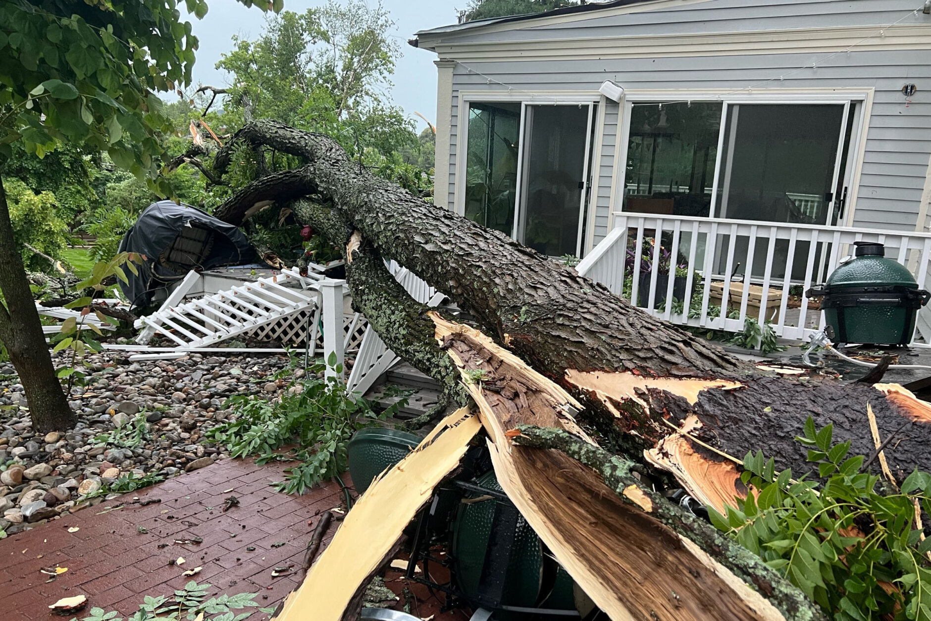
Winds of 80 to 90 miles per hour are uncommon in the Mid-Atlantic, but a destructive summer thunderstorm bellowed gusts estimated within this range. The storm ransacked parts of Virginia’s Fauquier and Culpeper counties on the afternoon of June 22.
The downburst plowed southbound from Marshall through Warrenton, acting as a blender as it pulverizing leaves and sent light-weight objects airborne. The National Weather Service collected reports of hundreds of downed trees, many crashing into homes. Initially, three structure collapses were reported in west-central Fauquier County.
Weather Service radar estimated wind speeds in excess of 90 miles per hour.
Damage to the power grid was described as “catastrophic” and “widespread.” Thousands were left in the dark for days.
Another powerful thunderstorm moved from D.C. toward Fredericksburg that afternoon, intensifying as it caused damage closer to Richmond.
 3/6
3/6
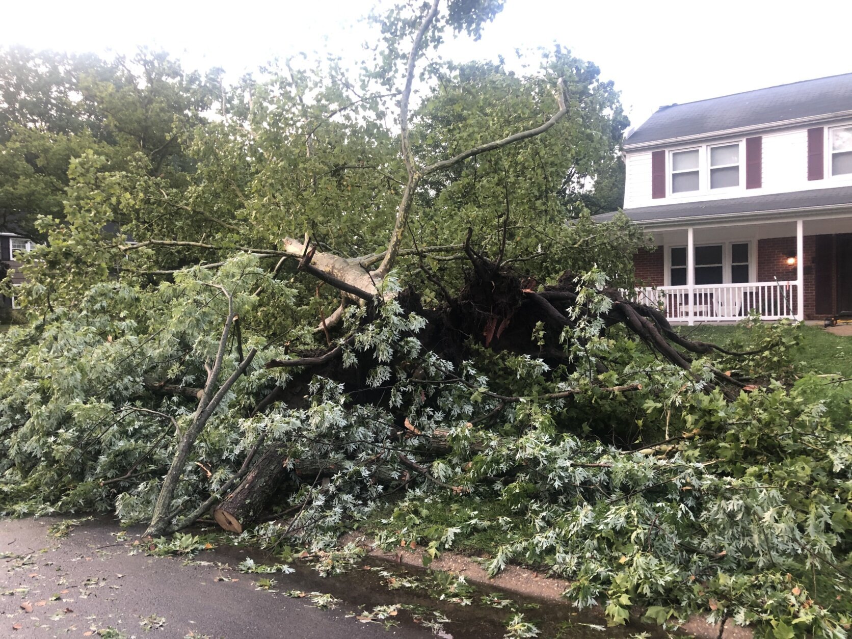
A moderate tornado whirled through Bowie, Maryland, on July 5, 2022.
The National Weather Service determined that the EF-1 tornado was only on the ground for about three minutes. It downed trees dozens of trees along a mile-long path through the “S” and “B” sections of Bowie.
There were no reported injuries, but a few homes were damaged by fallen trees.
The city water plant on Bradford Lane also sustained minor damage in the storm, but water service was not interrupted.
 4/6
4/6
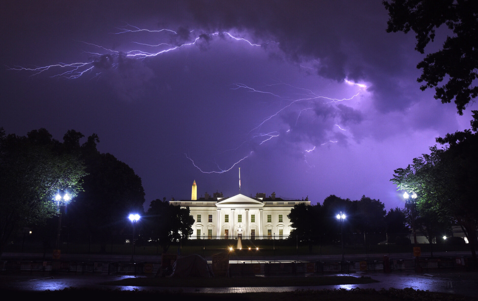
Three people were tragically struck by lightning and killed near the White House on Aug. 4. A fourth person was struck and injured but survived.
Powerful, drenching storms developed over the close-in Virginia suburbs during the evening and moved into D.C. around 7 p.m.
The Metropolitan Police Department confirmed James Mueller, 76, and Donna Mueller, 75, a retired couple from Janesville, Wisconsin, along with 29-year-old Brooks A. Lambertson of Los Angeles, California, died. They were struck by lightning while standing near a tree in Lafayette Park, a D.C. Fire and EMS spokesman said.
A fourth person, Amber Escudero-Kontostathis, was struck but survived. Escudero-Kontostathis later told NBC Washington that she was not sure why she pulled through, but she definitely is “not going to waste my second chance at life.”
The National Weather Service says being underneath a tree is the second leading cause of lightning casualties. If thunder is heard or lightning is seen, the safest place to be is inside a large enclosed structure with plumbing and electrical wiring. If no buildings are available, a metal vehicle such as a car, van or bus is a suitable alternative.
The left lanes of the Beltway Outer Loop in Greenbelt remain flooded and blocked by stalled vehicles. A Flash Flood Warning remain in effect. #MDWX #MDtraffic pic.twitter.com/Xdr71MIyLj
— Dave Dildine (@DildineWTOP) August 10, 2022
The stormiest period of the summer culminated with a deluge of flooding rain on Aug. 10, 2022. Northeast D.C. and Prince George’s County were hardest hit, with some neighborhoods receiving nearly three inches of rain in an hour.
Countless drivers were stranded in high water. Flash flooding submerged numerous roads between Bladensburg and College Park, Maryland, including parts of Kenilworth Avenue.
Prince George’s County Fire/EMS Department responded to 71 calls for water rescues through the evening.
 6/6
6/6
An air mass with origins close to the North Pole surged into the United States in late December, setting the stage for the coldest Christmas Eve in decades for Washingtonians. The low temperature at Reagan National Airport was nine degrees, making it the coldest airmass to infiltrate the area since January 2018.
Some locations in northwestern Virginia and northern Maryland dropped to near zero degrees with sub-zero winds chills.
Washington’s high for the day was a bone-chilling 22 degrees, the coldest maximum temperature ever recorded for Dec. 24.
The Christmas morning low was 14 degrees in D.C.
The airmass may have been cold, but it was also fleeting. Temperatures quickly modified, rising well above average during the final days of the year.