Workweek weather: Heat wave flows through but relief comes Wednesday

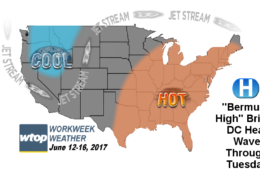
WASHINGTON — While colder than normal weather has settled into parts of the western United States, the better part of the eastern United States is in the middle of what will be the first heat wave of the summer. Of course, summer doesn’t actually start until June 21 at 12:24 a.m.


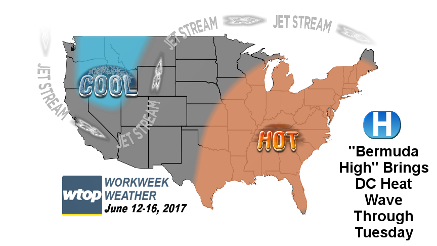
Like so many this area’s heat waves, this will be the result of a “Bermuda High,” a high pressure system centered near Bermuda, forcing a ridge in the jet stream well north into Canada, generating and transporting heat and also humidity from the Gulf of Mexico.

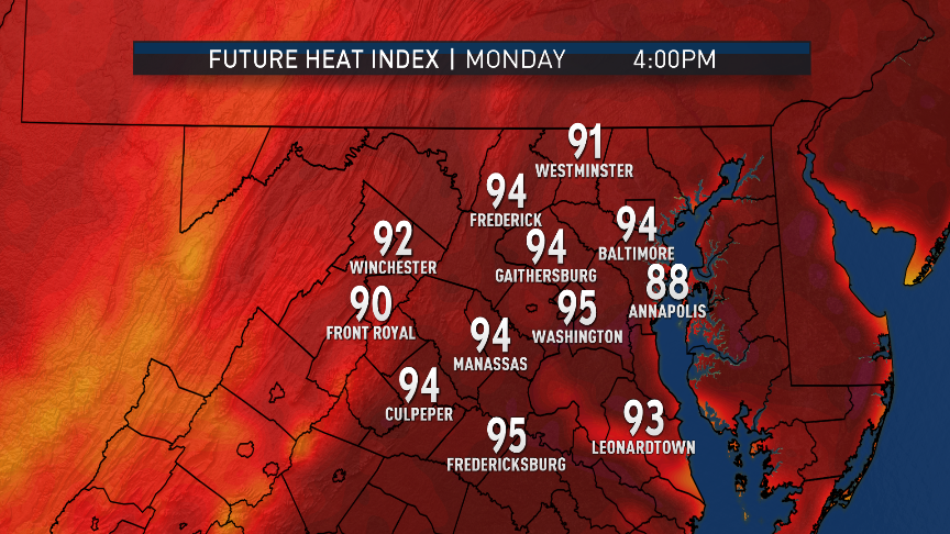
Sunday’s high at Washington-Reagan National was 93. So, we only need two more days in a row for a heat wave to be official. And that’s exactly what will happen.

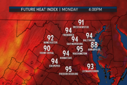
Temperatures will already have a running start by being in the 70s in the morning. Temperatures will rise rapidly after sunrise, easily getting into the 80s around lunchtime. Fair-weather clouds will start to form and slow the rate of the warming; but with all afternoon to go, it will be no problem getting into the low 90s.

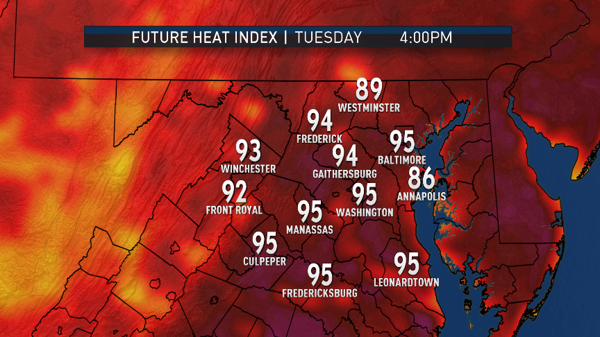
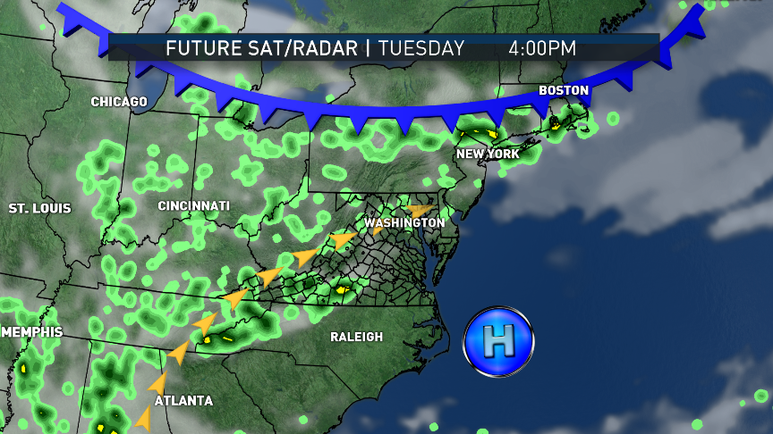
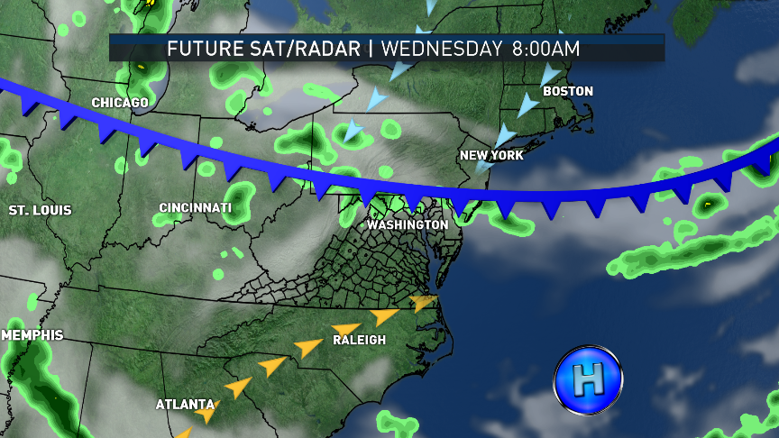
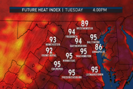
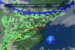
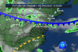
Almost the exact same scenario is on the way for Tuesday. It’s not until Wednesday that the ridge of high pressure will get “knocked down” a bit and allow a cold front to come in from the north. That will also give the atmosphere some lift and allow some scattered thunderstorms to form, unlike Monday or Tuesday.

Winds at the surface behind the front will become more northerly or northeasterly and set us up for a cool down the rest of the week. But, it will only be to more seasonably warm temperatures with lower humidity.

And indeed it won’t just be hot, it will also be humid. Dew point temperatures will be in the upper 60s and lower 70s. The higher the dew point, the higher the amount of moisture in the air. That range is definitely when it starts to feel oppressive. It also makes the temperature effectively hotter, the heat index. Such as the wind chill in winter, the heat index is a temperature’s adjustment relative to the human body’s ability to cool itself via sweat. The more humid it is, the less sweat evaporates, taking excess heat with it.

This type of heat this soon will likely be kind of a shock to the system, too. Take extra precaution to take it easy and stay cool and hydrated. Temperatures during the Washington Nationals’ games on Monday and Tuesday evening will likely remain in the 80s.

Wednesday’s cold front will return north, as a warm front on Friday, bringing another round of showers.

These graphics show computer projected Heat Index values for Monday and Tuesday afternoon. Remember, the Heat Index is a temperature adjustment based on humidity. (WTOP/Storm Team4)
The model (RPM) likely is under-doing the amount of atmospheric moisture there will be, so the heat index values aren't that much different than what thermometers will show. Still, this is way hot for June. (Data: The Weather Company. Graphics Storm Team4)
The model (RPM) likely is under-doing the amount of atmospheric moisture there will be, so the heat index values aren’t that much different than what thermometers will show. Still, this is way hot for June. (Data: The Weather Company | Graphics Storm Team4)
These graphics simulate the future satellite and radar data from the same model. Note the lack of much happening while we are in the heart of the Bermuda High, which ridges into the Carolinas.  (Data: The Weather Company. Graphics Storm Team4)
These graphics simulate the future satellite and radar data from the same model. Note the lack of much happening while we are in the heart of the Bermuda High, which ridges into the Carolinas. (Data: The Weather Company | Graphics Storm: Team4)
The air is primarily sinking/compressing in this pattern, warming the mid layers of the atmosphere, preventing much thunderstorm formation. When a cold front backs its way in on Wednesday, there will be more lift to the atmosphere and a chance for thunderstorms.  (Data: The Weather Company. Graphics Storm Team4)
The air is primarily sinking/compressing in this pattern, warming the mid layers of the atmosphere, preventing much thunderstorm formation. When a cold front backs its way in on Wednesday, there will be more lift to the atmosphere and a chance for thunderstorms. (Data: The Weather Company | Graphics: Storm Team4)
Fair weather clouds will start to form and slow the rate of the warming, but with all afternoon to go, it will be no problem getting into the low 90s. (Data: The Weather Company | Graphics: Storm Team4)
Cooler weather will follow. (Data: The Weather Company. Graphics Storm Team4)
Cooler weather will follow. (Data: The Weather Company | Graphics: Storm Team4)
(1/6)
These graphics show computer projected Heat Index values for Monday and Tuesday afternoon. Remember, the Heat Index is a temperature adjustment based on humidity. (WTOP/Storm Team4)
The model (RPM) likely is under-doing the amount of atmospheric moisture there will be, so the heat index values aren't that much different than what thermometers will show. Still, this is way hot for June. (Data: The Weather Company. Graphics Storm Team4)
These graphics simulate the future satellite and radar data from the same model. Note the lack of much happening while we are in the heart of the Bermuda High, which ridges into the Carolinas.  (Data: The Weather Company. Graphics Storm Team4)
The air is primarily sinking/compressing in this pattern, warming the mid layers of the atmosphere, preventing much thunderstorm formation. When a cold front backs its way in on Wednesday, there will be more lift to the atmosphere and a chance for thunderstorms.  (Data: The Weather Company. Graphics Storm Team4)
Cooler weather will follow. (Data: The Weather Company. Graphics Storm Team4)
Daily weather highlights

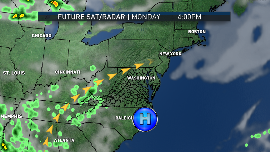
Monday and Tuesday: Abundant hazy sunshine with scattered fluffy clouds. Near record heat.

Wednesday: Not as hot because of increasing cloud cover. Very warm and very humid. Scattered thunderstorms developing, some slow movers with potential downpours.

Thursday: Mostly cloudy and breezy. Temperatures much closer to average (low 80s).

Friday: Cloudy, warm, and more humid. Showers and thunderstorms.

Here are some stats on the records for this heat wave, compiled by the National Weather Service office in Sterling, Virginia

Monday, June 12

Record high Record warm low
DCA 95 (2002)* 77 (2015)
BWI 96 (1986)* 77 (1947)
IAD 96 (1986) 72 (1986)


Tuesday, June 13

Record high Record warm low
DCA 96 (1954) 75 (2015)
BWI 97 (1956) 74 (1942)
IAD 94 (1994) 72 (2005)


Wednesday, June 14

Record high Record warm low
DCA 98 (1994) 78 (2015)
BWI 98 (1994) 74 (2001)*
IAD 98 (1994) 73 (1994)


*Indicates record set in previous years, as well.

Federal News Network Logo
Log in to your WTOP account for notifications and alerts customized for you.

Sign up