EDITOR’S NOTE: This is an overview of the weather outlook for the D.C. area over the next few days. For the latest forecast, go to WTOP’s Weather page.
WASHINGTON — Rain has been falling on parts of the D.C. region since Wednesday, but the area is seeing a diminishing threat for flash flooding through Thursday night.
A Flash Flood Watch in effect for the region through 8 a.m. Friday was canceled Thursday evening, and the biggest flash flooding threat has passed. The area will still be impacted by some showers through Saturday, and most of the area will pick up 2 to 5 inches of rain total.
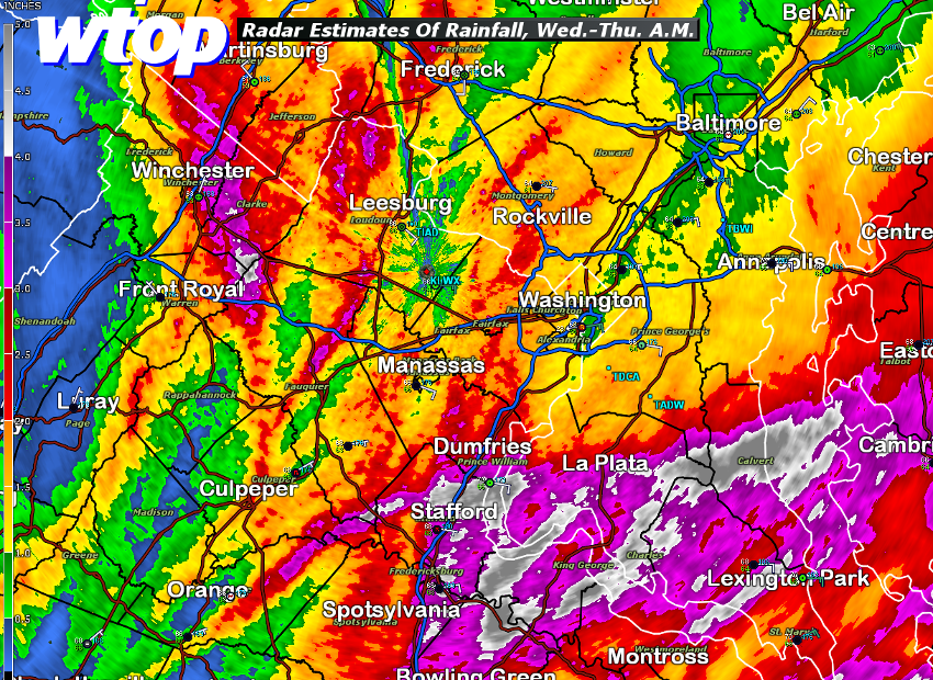
In southern Maryland there have been reports of higher amounts. In Mechanicsville and Prince Frederick there is about 6 to 7 inches.
We will continue to see light to moderate rain across the region through the day Saturday, but the heaviest rain is just about over.
The radar estimated rainfall graphic shows that the region got over an inch of rainfall, with heavier embedded amounts. The rains near Winchester actually did cause flash flooding early in the morning. The colors for southern Maryland include all the rain from the thunderstorms of Wednesday, plus the rains of Thursday.
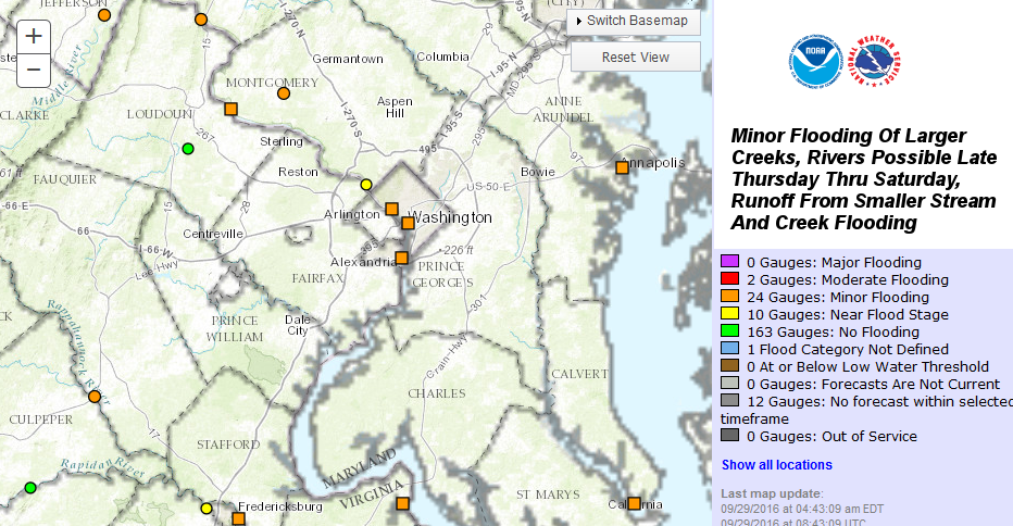
Additional showers are on the way while this cutoff area of low pressure affects us, and with all the floodwaters from Thursday having to go somewhere, the focus now shifts to some of the larger creeks and rivers, including the Potomac.
The computer models for river and creek gauge levels at the Middle Atlantic River Forecast Center indicate that minor flooding in the typical locations may happen later Thursday, with the swells working their way to the Potomac over the weekend. To put it in perspective: This would be the type of minor flooding with the usual impacts in the usual spots.
Timing
Rain continues into Thursday, heavy at times with more showery activity expected for Friday. As the low begins to retreat north on Saturday, rain will start to end across the region from the south to the north.
Until then, just prepare yourself for a lot of rain to move into the region. Stay tuned to WTOP for weather updates and remember — don’t attempt to drive into floodwater: Turn around — don’t drown.
Storm Team 4’s Amelia Draper and Doug Kammerer contributed to this report.