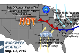
WASHINGTON — August begins with an ongoing official heat wave since the high temperature has officially been 90 degrees or above each day from July 21 — many more than the required three days in a row.
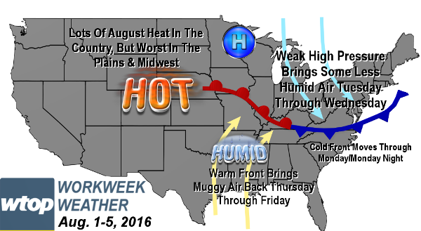
Some days have been extremely hot and we’ve had varying degrees of comfort based on the humidity levels. This new workweek will be similar to the last inasmuch as there will be a front going through in the beginning of the week with the humidity dropping a bit midweek before roaring back again by the end of the week.
The worst of the heat will be confined to the Midwest again. However, the front this time around won’t meander around the area, providing chances for scattered thunderstorms a lot of the time. Also, there are stronger indications that the heat wave will finally break on Wednesday — if not Tuesday — when high temperatures look much more likely to stay in the 80s instead of being borderline 90 like last Friday. That day did get a bit more sunshine after the morning thunderstorms, getting the high at Reagan National Airport to 92 degrees, and of course we got into the 90s all weekend.
Daily weather highlights
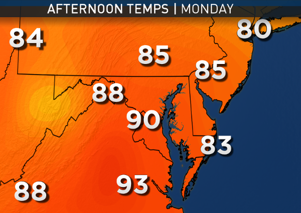
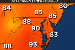
MONDAY:
• Starts out warm and muggy in the morning
• A few widely scattered showers or thunderstorms along the cold front coming down from Pennsylvania
• Humidity drops from muggy levels to just sticky during the evening
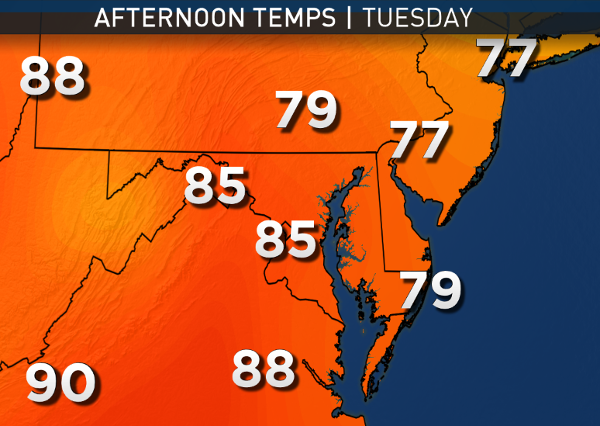
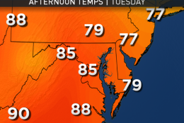
TUESDAY:
• Lots of fluffy, cumulus clouds on a northerly breeze, blocking the sun on and off
• A stray shower from a couple of those clouds not out of the question
• High temperatures borderline with 90
• Humidity just at sticky levels
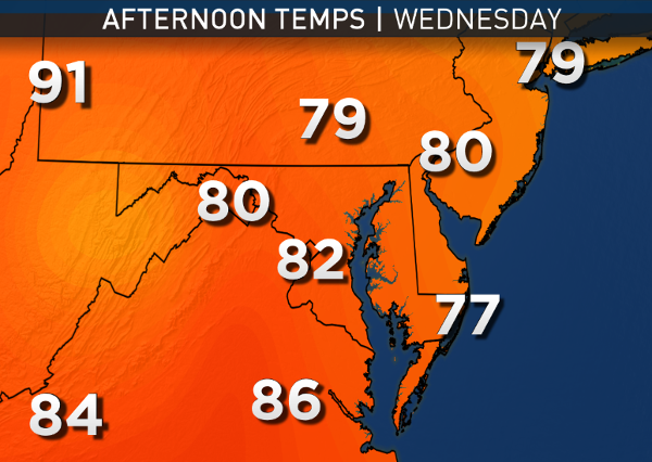
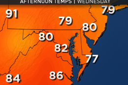
WEDNESDAY:
• Weak Canadian high pressure brings mostly sunny skies before clouds start increasing in the afternoon
• Very good chance high temperatures stay in the 80s, breaking the heat wave
• Temperatures in mid to upper 80s are more seasonable, closer to average
THURSDAY:
• Warm front starts moving back up from the south
• Morning thunderstorms may accompany front, if they don’t stay in the Ohio Valley
• Very warm temperatures, but humidity starts climbing back up to muggy levels
FRIDAY:
• Hazy, hot and humid “dog days” weather returns
• Nationals will have to keep an eye to the sky for isolated thunderstorms to greet the new homestand with San Francisco
Here’s a look at the high temperature history for Washington-Reagan National since the heat wave began more than a week ago. Note that we were only close to the record highs for a short time in the wave’s first few days, and we only tied a record once, during that whole stretch.
| DATE | OBSERVED HIGH | RECORD HIGH | RECORD HIGH YEAR |
|---|---|---|---|
| Thursday, July 21 | 90 | 104 | 1926 |
| Friday, July 22 | 95 | 103 | 1926 |
| Saturday, July 23 | 98 | 102 | 2011 |
| Sunday, July 24 | 97 | 101 | 2011 |
| Monday, July 25 | 100* | 100 | 1930 |
| Tuesday, July 26 | 98 | 103 | 1930 |
| Wednesday, July 27 | 97 | 100 | 1940 |
| Thursday, July 28 | 95 | 100 | 1997 |
| Friday, July 29 | 92 | 104 | 2011 |
| Saturday, July 30 | 90 | 99 | 1953 |
| Sunday, July 31 | 92 | 103 | 1954 |
| Monday, August 1 | TBD | 100 | 2011 |
Editor’s note: The WTOP Workweek Weather Blog is intended as an in-depth yet plain language summary of the business week’s weather potential in the D.C. area along with an explanation of the contingencies and uncertainties that exist at the time of publication. For the latest actual Storm Team 4 forecast, check out the main WTOP Weather Page.