January is turning out to be a boon for the D.C. region’s winter weather lovers, with a chance for more snow in store for this weekend.
Meteorologists are monitoring forecasts for another storm in the mid-Atlantic and Northeast from a Sunday afternoon to Monday morning time frame. Bitter cold returns Friday night, meaning Sunday’s storm will kick off around noon with snow for most.
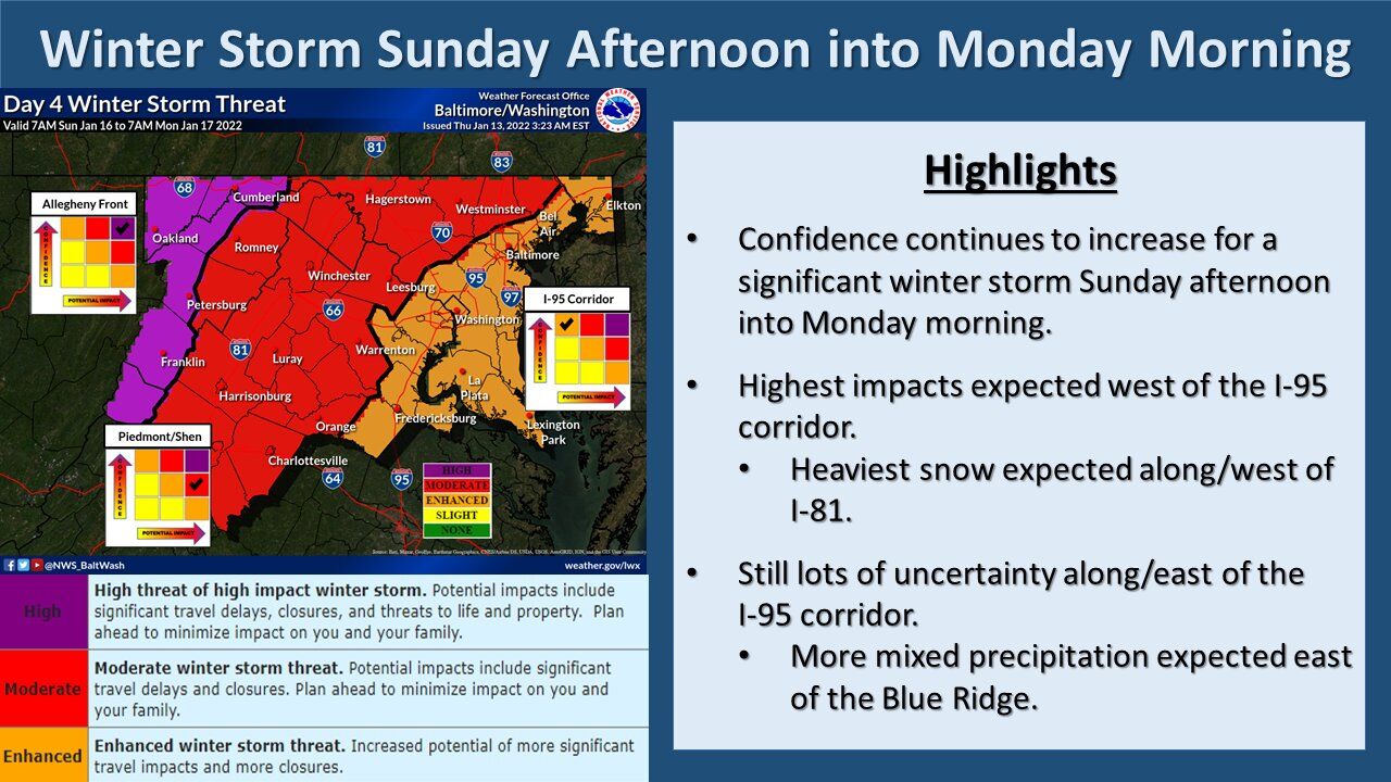
But like with so many winter storms, computer models are in substantial disagreement over the storm’s ultimate path. Forecasts show a sharp split between the storm’s warm and cold halves over the Interstate 95 corridor: A veer to the right would lead to a prolonged period of snowfall for D.C. and Baltimore proper, while a swing to the left would see a change to rain outside of Northern Maryland and the Blue Ridge.
“With all eyes looking toward a winter storm on Sunday, take advantage of the quiet weather we’ll have today to start storm preparations,” Storm Team4 meteorologist Chuck Bell said. “Simple things like keeping your car’s gas tank full, re-filling any needed medications, have de-icing materials for your steps and sidewalks, and moving any Sunday night or Monday morning travel plans if possible.”
- Listen to WTOP online and on the radio at 103.5 FM or 107.7 FM.
- Current traffic conditions
- Weather forecast
- Closings and Delays
- Sign up for WTOP alerts
Models bring the main center of the low pressure system along or just inland of the coastline, putting the rain-snow line almost right on top of I-95. But despite lingering uncertainty, confidence is high that at least some snow will fall on Sunday evening before any transition to rain. Plows are likely to be busy for a time, and roads slick.
“It’s too early for predicting exacts totals, but there’s an 80% chance of a plowable snow for most (if not all) of the area,” Bell said. “The storm’s timing, a Sunday night before a federal holiday on Monday, will dramatically reduce the number of people that ‘need’ to be on the roads. This will allow road crews to better keep up with plowing duties and should reduce the duration of travel issues.”
High totals are expected for regions far enough removed from the rain-snow line that cold air will remain entrenched. Residents of Virginia’s Blue Ridge, the Shenandoah Valley and Northern Maryland could get up to a foot of snow from this storm. As of Thursday, the National Weather Service predicts a moderate- to high-impact event along and west of Interstate 81.
“It is going to depend on how far west you are … still thinking areas east of the Blue Ridge will change over to a wintry mix and even to all rain at some point,” the weather service said in its forecast discussion. “For areas west of the Blue Ridge out to the Alleghenies … this is where we will likely see the big winners in terms of snowfall with this event.”
The Virginia Department of Transportation is not taking chances, especially after delays on I-95 near Stafford County stranded drivers for several hours last week.
VDOT said crews will begin pretreating I-95 around Fredericksburg, the Northern Neck and Middle Peninsula Thursday morning in preparation for the possibility of snow and ice arriving.
Transportation officials apologized for what happened and said there is an interagency action report being put together reviewing what actions were taken before and during the storm, and what lessons can be learned going forward.
Forecast:
Friday: Morning clouds and afternoon sunshine. Blustery and turning colder, with highs in the low 40s.
Saturday: Mostly cloudy. Freezing and breezy. Highs in the upper 20s to low 30s.
Sunday: Snow sets in around noon, with a wintry mix or rain possible after dark. Highs in the mid 30s.


