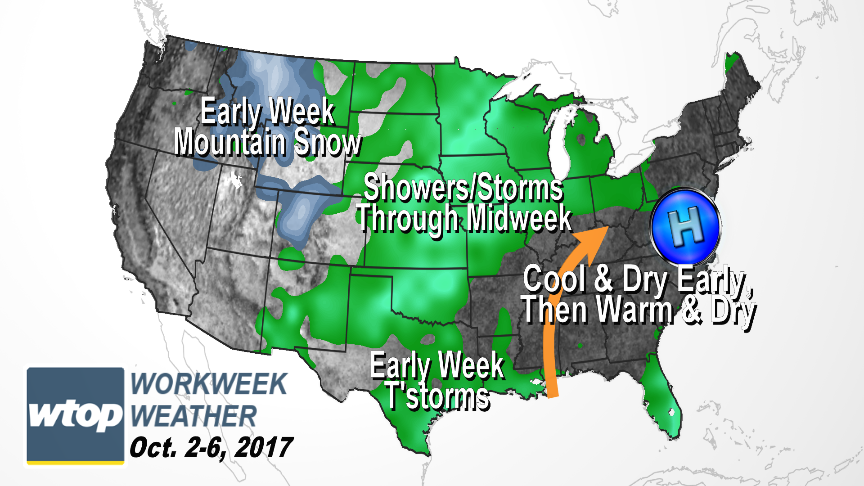
This same dome of high pressure will continue to dominate the weather pattern for the entire week. This will mean some temperature swings, but it also means almost no chance of needed rain until almost Friday.
It was certainly a fantastic weekend weather-wise courtesy of a big dome of high pressure building in from Canada.
This same dome of high pressure will continue to dominate the weather pattern for the entire week. This will mean some temperature swings, but it also means almost no chance of needed rain until almost Friday.
The dry air and clear skies at night will mean a few almost chilly mornings until the second half of the week, when the center of the high shifts slightly offshore and a change in wind direction will bring in more humidity.
Milder starts to the mornings, sunshine and southwesterly winds will lead to summerlike temperatures in the afternoons. A weak cold front will approach the area on Friday and basically stall out. But that may provide just enough lift to the atmosphere with the increased humidity to bring a few light showers.
It’s not back in a formal drought yet, but September finished 2.29 inches of rainfall below average for the month (Washington-Reagan National data) and the topsoil is getting pretty dry. The are could use an all-day soaking rainstorm for that reason alone. Further down the road when there would be plenty of fallen dry leaves, fire weather danger would only increase.
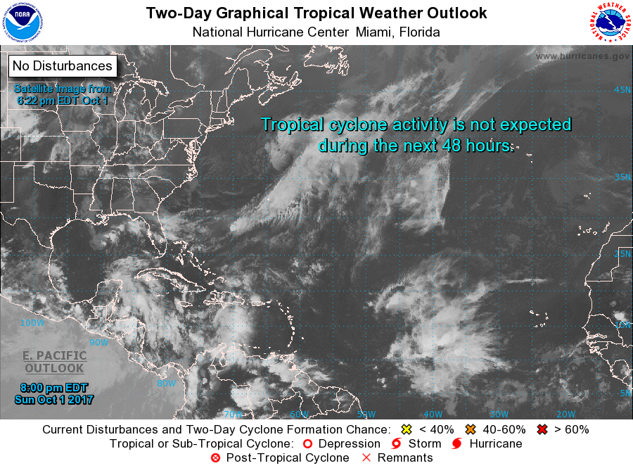
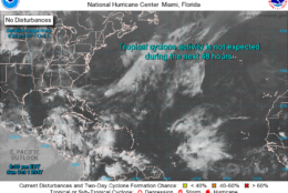
Also worthy of note, as of this article’s publication, there is no active tropical activity in the Atlantic Ocean.
Seasonable average highs this week are in the low to mid 70s and average lows are in the mid 50s.
Seasonable average highs this week are in the low to mid 70s, and average lows are in the mid 50s.
(WTOP/Storm Team 4)
WTOP/Storm Team 4
Also worthy of note, as of this article’s publication, there is no active tropical activity in the Atlantic Ocean
(National Hurricane Center/NOAA)
National Hurricane Center/NOAA
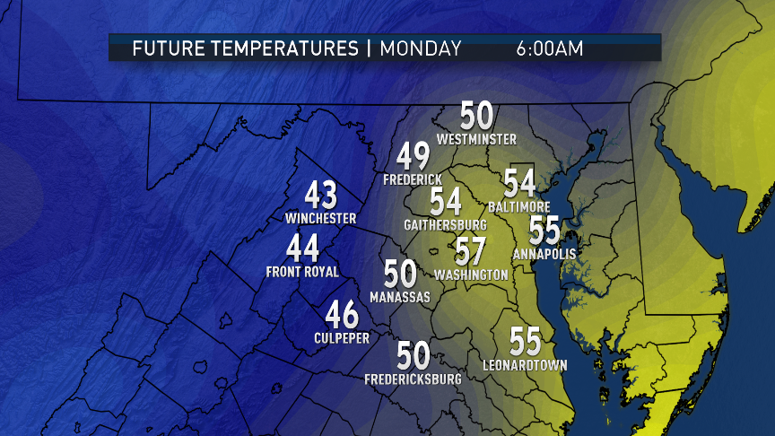
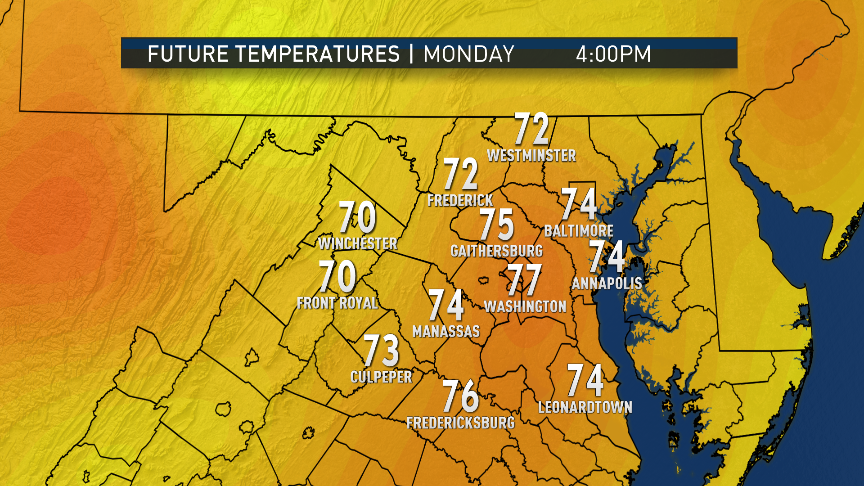
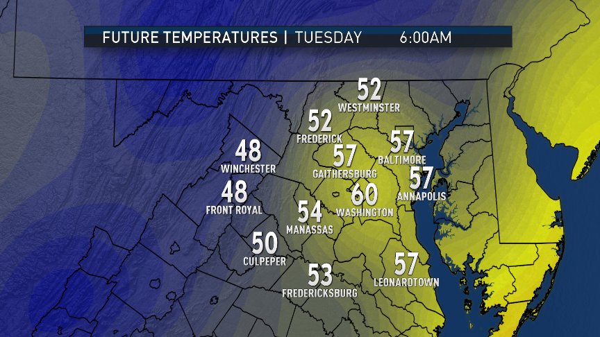
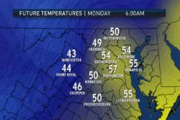
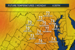
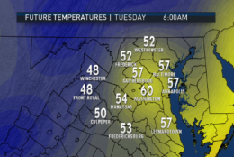
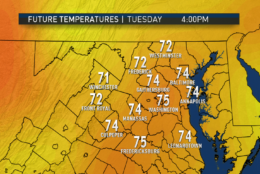
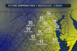
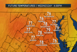
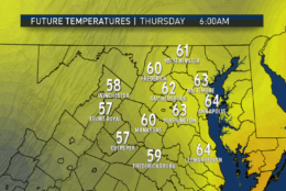
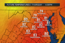
The GFS computer model shows the likely trend in temperatures this week, starting off chilly in the mornings early in the week, then gradually building back to milder morning lows and much warmer afternoon highs. The wide range in potential low temperatures Tuesday and Wednesday mornings will be due to variations in wind direction and humidity (drier areas will be cooler). There is the potential for Friday to be cooler than shown if the next cold front is faster and brings in the clouds sooner.
(Data: Weather Prediction Center/NOAA | Graphics: Storm Team 4)
Data: Weather Prediction Center/NOAA | Graphics: Storm Team 4
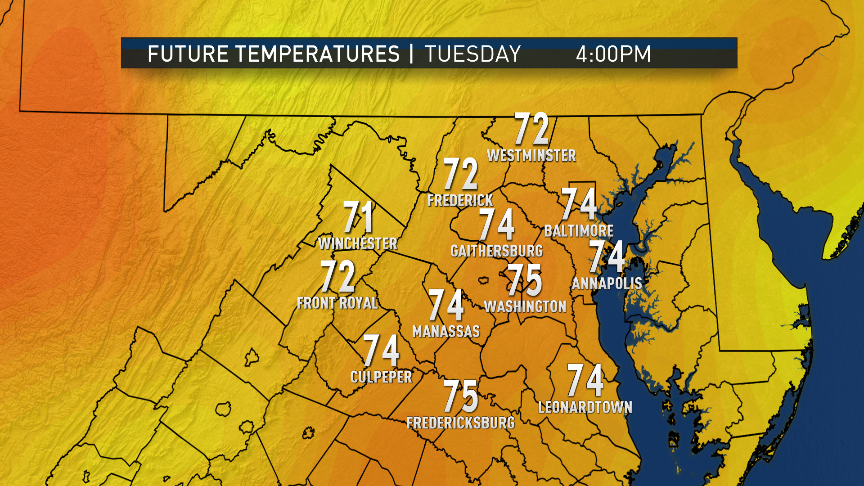
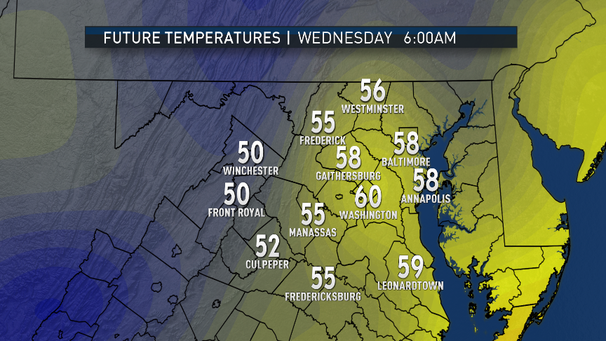
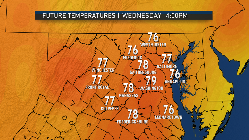
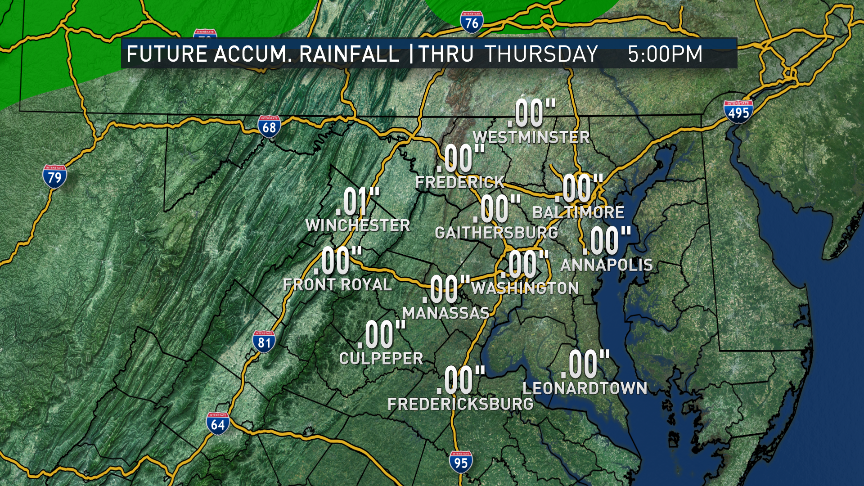
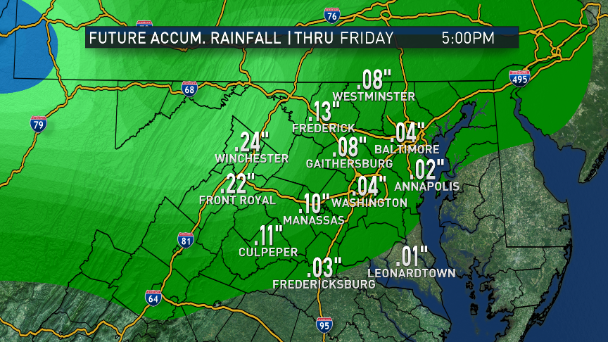
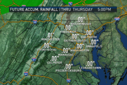
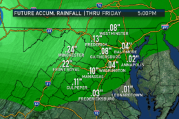
It looks like the dry spell will continue through most of the week. The GFS also shows no accumulated rainfall from now through Thursday, and only a potential for light amounts on Friday.
(Data: Weather Prediction Center/NOAA | Graphics: Storm Team 4)
Data: Weather Prediction Center/NOAA | Graphics: Storm Team 4
Clear and chilly start, especially in the rural areas
Abundant sunshine
Warming quickly after sunrise
Seasonable highs in the afternoon
Very low humidity and light winds out of the north
Tuesday
Mostly clear start except near the Chesapeake, a risk of low level cloudiness there
Chilly start but near the Bay not as chilly
Light winds, variable wind direction
Slightly more humid, still very comfortable
Wednesday
Cool start in the morning with patchy fog
Mostly sunny skies all day with warmer than average temperatures
Slightly more humid but again still very comfortable
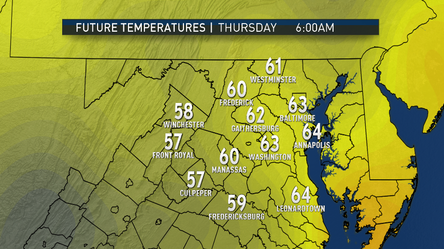
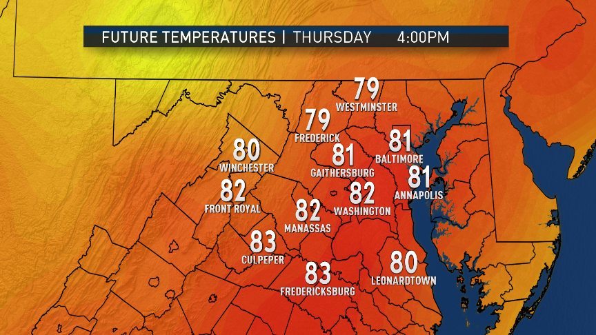
Thursday
Mild start in the morning with patchy fog
Starting to really notice the increased humidity, feeling sticky
Temperatures well above average, feeling like summer
Sunshine with a mix of fair weather clouds
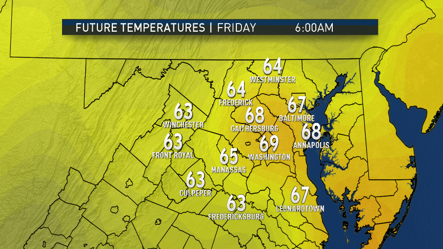
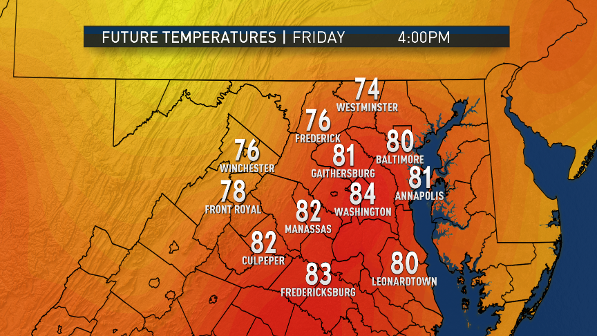
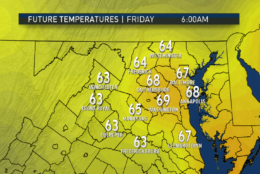
Friday
Muggy by October standards
Increasing clouds during the day, especially north of Washington
Chance of light showers or drizzle
Summerlike temperatures if clouds are delayed later, lots of uncertainty
Editor’s Note: The WTOP Workweek Weather Blog is intended as an in-depth yet plain language summary of the business week’s weather potential in the D.C. area along with an explanation of the contingencies and uncertainties that exist at the time of publication. For the latest actual Storm Team 4 forecast, check out the link on the main WTOP Weather Page.