Workweek weather outlook: Cold fronts bring comfortable changes

 A look at the workweek weather for June 6 to June 10. (WTOP/Storm Team 4)
A look at the workweek weather for June 6 to June 10. (WTOP/Storm Team 4)
This image shows the general configuration of the jet stream this week. Summerlike heat will be shifted into the nation’s midsection, while dry air takes over the Northeast and the Midatlantic. North of the dip in the jet stream, temperatures will be quite cool. (WTOP/Storm Team 4)
This image shows the general configuration of the jet stream this week. Summer-like heat will be shifted into the nation’s midsection, while dry air takes over the Northeast and the Mid-Atlantic. North of the dip in the jet stream, temperatures will be quite cool. (WTOP/Storm Team 4)
On Monday, the cold front which went through with the severe weather on Sunday will be to our east. (National Weather Service/NOAA)
The next front will pass through on Tuesday. (National Weather Service/NOAA)
The next front will pass through Tuesday. (National Weather Service/NOAA)
This image and the next one show the difference in dew-points from Sunday to the middle of the week. Without getting into the technical definition of what dew-points are, it’s easy to remember the general effects they have on our comfort levels in this part of the country. When they’re in the 70s or higher it always feels muggy and oppressively humid. When they’re in the 60s it feels sticky but not necessarily uncomfortable. When they’re in the 50s it feels great. When they’re in the 40s like it looks like they will be this week, it’s nothing less than a bonus. (National Weather Service/NOAA)
This image and the next one show the difference in dew points from Sunday to the middle of the week. Without getting into the technical definition of what dew points are, it’s easy to remember the general effects they have on our comfort levels in this part of the country. When they’re in the 70s or higher, it always feels muggy and oppressively humid. When they’re in the 60s, it feels sticky but not necessarily uncomfortable. When they’re in the 50s, it feels great. When they’re in the 40s — like it looks like they will be this week — it’s nothing less than a bonus. (National Weather Service/NOAA)
 Dewpoints are a much better benchmark of mugginess compared to relative humidity. The relative humidity can be 100% in stormy and foggy conditions throughout the year. But a relative humidity of 100% in a snowstorm will never feel muggy. In fact, the dewpoints in a typical snowstorm will probably be in the 20s. (National Weather Service/NOAA)
Dew points are a much better benchmark of mugginess compared to relative humidity. The relative humidity can be 100 percent in stormy and foggy conditions throughout the year. But a relative humidity of 100 percent in a snowstorm will never feel muggy. In fact, the dew points in a typical snowstorm will probably be in the 20s. (National Weather Service/NOAA)
(1/6)
 A look at the workweek weather for June 6 to June 10. (WTOP/Storm Team 4)
This image shows the general configuration of the jet stream this week. Summerlike heat will be shifted into the nation’s midsection, while dry air takes over the Northeast and the Midatlantic. North of the dip in the jet stream, temperatures will be quite cool. (WTOP/Storm Team 4)
On Monday, the cold front which went through with the severe weather on Sunday will be to our east. (National Weather Service/NOAA)
The next front will pass through on Tuesday. (National Weather Service/NOAA)
This image and the next one show the difference in dew-points from Sunday to the middle of the week. Without getting into the technical definition of what dew-points are, it’s easy to remember the general effects they have on our comfort levels in this part of the country. When they’re in the 70s or higher it always feels muggy and oppressively humid. When they’re in the 60s it feels sticky but not necessarily uncomfortable. When they’re in the 50s it feels great. When they’re in the 40s like it looks like they will be this week, it’s nothing less than a bonus. (National Weather Service/NOAA)
 Dewpoints are a much better benchmark of mugginess compared to relative humidity. The relative humidity can be 100% in stormy and foggy conditions throughout the year. But a relative humidity of 100% in a snowstorm will never feel muggy. In fact, the dewpoints in a typical snowstorm will probably be in the 20s. (National Weather Service/NOAA)

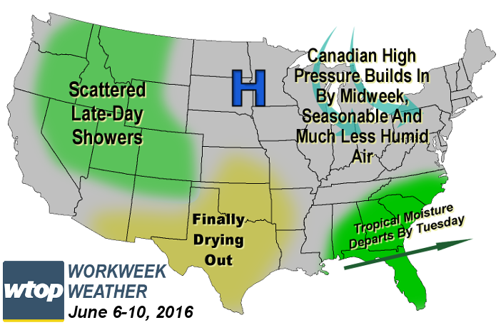
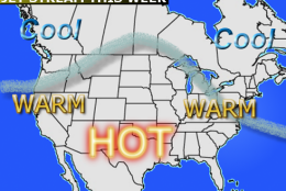
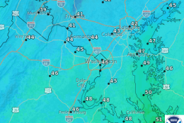
WASHINGTON — The cold front that brought severe weather to parts of the area Sunday is the first of two cold fronts that will bring more comfortable weather for the new week.

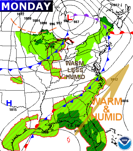
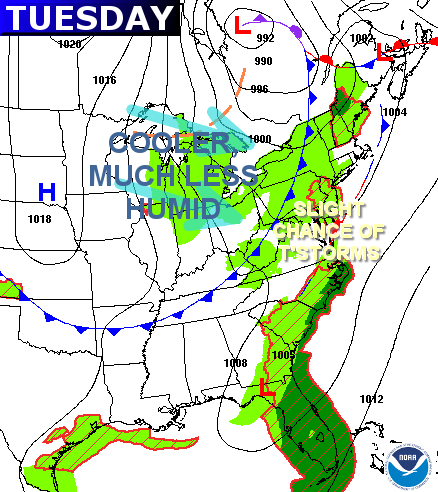
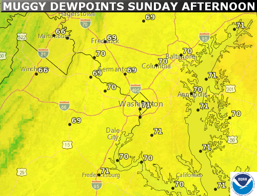
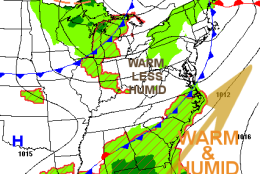
Humidity levels over the weekend were very high for our part of the country, but already folks will notice a difference Monday. The second cold front direct from central Canada will pass through Tuesday with a slight chance of some thunderstorms or at least some scattered showers.

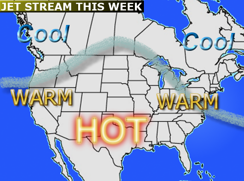
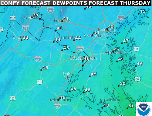
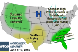
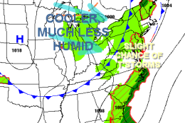
But then the humidity will really drop for the middle of the week as Canadian high pressure moves into the middle of the country, keeping us in northwest flow. Temperatures will be close to seasonable for most of the week with the biggest notable differences day-to-day being the humidity.

Moisture from what will likely be Tropical Storm “Colin” may bring some heavy rainfall to parts of the southeast, but Tuesday’s cold front will keep that suppressed too far south to affect us.

As the high pressure system builds in directly overhead by the end of the workweek, we will enjoy sunny skies, dry weather, and a gradual rebound in temperatures and humidity as we head into the weekend when the high will start moving away.

The weather looks great for the Orioles’ homestand this week except for the slight chance of a shower Tuesday. By the time the Nationals get back to town to face the Phillies, the weather will also be great, but will be warming back up again.

Daily weather highlights

Monday
• Day starts out with some patchy fog in areas that got thunderstorms
• A good amount of sunshine with fair weather, cumulus clouds all day
• Humidity levels will feel more typically “sticky” compared to the mugginess of Sunday
• Temperatures still fairly warm

Tuesday
• Increasing clouds ahead of next cold front
• Showers and thunderstorms chances are there, but they’re not very high chances
• As front goes through, it gets breezy

Wednesday
• Lots of sunshine
• Breezy with slightly below average high temperatures; may not make it into the 80s

Thursday/Friday
• Again, lots of sunshine
• Slightly warmer and more seasonable, but very dry air and very comfortable

Editor’s note: The WTOP Workweek Weather Blog is intended as an in-depth yet plain language summary of the business week’s weather potential in the D.C. area along with an explanation of the contingencies and uncertainties. For the latest actual Storm Team 4 forecast, check out the main WTOP Weather Page.

Federal News Network Logo
Log in to your WTOP account for notifications and alerts customized for you.

Sign up