Editor’s Note: This article is intended as an in-depth but plain language discussion for the Washington area’s weather factors, ingredients, and the uncertainties involved. For the latest Storm Team 4 Forecast details, check out the main WTOP Weather Page.
WASHINGTON — It was certainly a dreary and wet first week of May. Luckily the rains were needed and we did reduce the deficits for the year and last few months substantially.
The deficit for the time period beginning March 1 is now just under an 1 1/2 inches and the deficit for the year is below half-an-inch. More rainfall is on the way for the new workweek but without the blocked weather pattern in place anymore, the rainfall is unlikely to be as soaking.
A cold front went through early on Mother’s Day morning, ushering in the dry air and the breezy conditions. High pressure will settle in over New England and slow down the front’s progress in trying to return north. The moisture from the Gulf of Mexico overrunning the front at the surface will mean more clouds and chances for showers to start out the week, and that scenario will last for several days. But most of the jet stream energy and available moisture will be in middle of the country, so most of the rain and thunderstorms (some very likely severe) will be there.
The area will end up with a lot of cloudiness and a few small batches of showers moving through from time to time. With northerly winds and less sunshine, temperatures won’t be as high as they were on Sunday. Wednesday should have a break in the action, although it will be close call. Timing every little mini disturbance is very difficult. But the threat for showers will really increase toward the end of the workweek with energy from the storm center getting closer and more moisture from the Gulf of Mexico involved.
The warm front will finally make it all the way through Thursday night, making Friday likely the warmest day of the week. But then a cold front will pass through with some likely thunderstorms, followed by drier weather for the weekend.
So overall, it won’t seem like a lot is happening this week. The actual forecast details will seem very similar day-to-day, especially to start the week. The biggest challenges to fine tune will be whether we stay dry for most of Wednesday and whether there will be thunderstorms (and how strong) on Friday.
One thing’s for sure: there is a lot of lawn mowing to be done.
Daily weather points
Monday and Tuesday
Wednesday
- Sun likely peeking through the overcast, but unlikely to amount to much.
- Most of the day should be dry, but that may change.
- May end up being just like Monday and Tuesday.
Thursday
- Still plenty of cloud cover, but winds start changing direction as warm front starts moving through.
Friday
- The threat for showers continues for another day, but this time with a chance for thunderstorms, also.
- Considering the thunderstorm threat, likely the day with the most rainfall amounts, but only where the actual storms move through. We won’t all benefit.
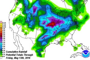
Below is the Weather Prediction Center’s cumulative precipitation map for the country through Friday morning. With the storm centers and big thunderstorms, the largest amounts will be in the middle of the country. Over the course of the whole week, there will only be in the vicinity of a half inch. There could be a little more than that but it’s not likely that there will be less.
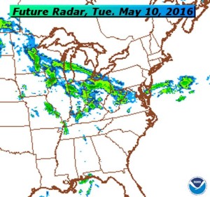
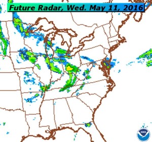
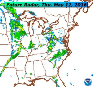
These next maps are computer simulations of future radar from the North American Mesoscale (NAM) Model for Tuesday through Thursday. Rainfall intensity is never too heavy, and notice there are lots of breaks. So the precipitation will more showery, as opposed to a steady rain like we had this past Friday.
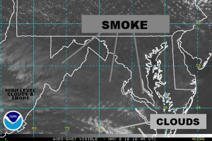
Now for some local involvement in world environmental news: over the weekend the region was affected by the wildfires in Alberta, Canada. The upper level winds, primarily out of the northwest, were transporting smoke over the area in the form of the hazy appearance to the sky on Sunday. This was before the actual clouds moved back in during the afternoon and evening.
If not for the smoke, we would have been completely sunny in the midday hours. The close-up, high resolution visible satellite picked it up quite well and is seen in the image below from just before noon. Again, the smoke was very high altitude so our air quality at the surface was not affected.