WASHINGTON — Last week featured a decent amount of needed rainfall. As of last Sunday’s blog posting, we had a substantial rainfall deficit and our topsoil was getting close to the lowest end of official drought conditions. But we have gained some ground.
For this work week, disturbances in the jet stream riding along a meandering front will mean several chances for even more beneficial rains. Around midweek, another blocked weather pattern typical for spring (called the Omega Block) will establish itself. Unlike the last block, we won’t be on the sunny and dry side of things, but in one of the cool and unsettled areas.
This will keep at least the threat of rain all the way through Mothers’ Day weekend. As far as temperatures go, Monday looks like the only day on which the front will be to our north, keeping us in the “warm sector.” It will feel warm and humid, but then the front will return as a cold front in the evening, touching off more showers and thunderstorms.
There are some voices in the world of the computer models that say the front will stall right over us on Tuesday, and that would mean some of us could still have some warm temperatures, especially south of D.C. But the recent weather pattern suggests the front will indeed slide farther south, keeping all of us cooler Tuesday.
Enough dry air should suppress the rain south on Wednesday, bringing us a mostly dry day, but it will be really close. That’s also when the blocked pattern will be digging, so it’s possible it will start raining again Wednesday evening. Then we will wrap up the work week with scattered showers and well-below-average temperatures.
Daily weather points
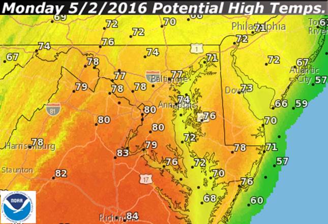
Monday
- Starts out cloudy, damp, drizzly and, in many spots, foggy.
- The warm front slowly moves through during the midday hours.
- Spots that get sunshine will end up very warm and almost feeling muggy, and those spots will most likely be D.C. and points south. The closer to Pennsylvania you are, the longer it will take to see any sun.
- A cold front will bring a threat of rain and thunderstorms for the evening.
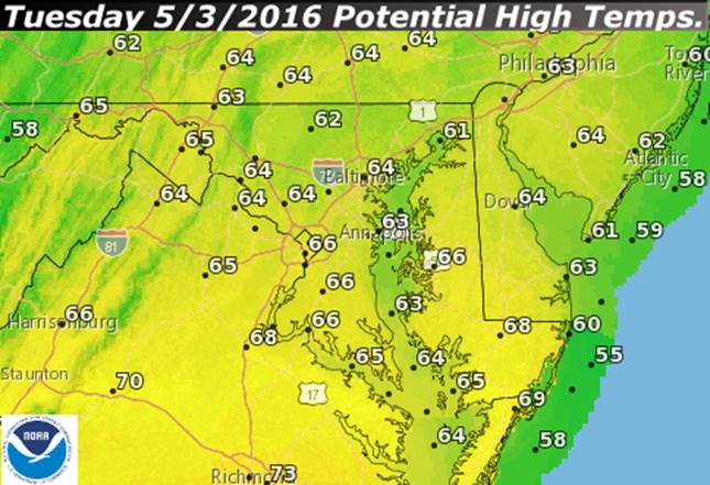
Tuesday
- Rain likely in the morning, tapering to drizzle.
- The weather will resemble Sunday’s quite a bit.
- Central Virginia over to the Northern Neck and extreme southern Maryland may end up warmer.
Wednesday
- Still a lot of clouds, but most of the day likely is dry.
- A lot of uncertainty regarding when the rain returns, possibly as early as the evening rush.
Thursday and Friday
- Cloudy skies, cool temperatures.
- Spotty, occasional showers.
- Little weather difference between the two days.
Here are temperature forecasts from the National Weather Service for Monday and Tuesday. On Monday, the front will be up north near Pennsylvania. On Tuesday, the front will be traveling south of us again. Those temperatures will be common for the rest of the week. Keep in mind, the 30-year average high temperatures for Washington-Reagan National this week are in the low 70s.
This next graphic shows the estimates of rainfall last week, based on radar estimates and rain gauges. Most of it was from the weekend: Good, soaking rainfall of about a half-inch to an inch.
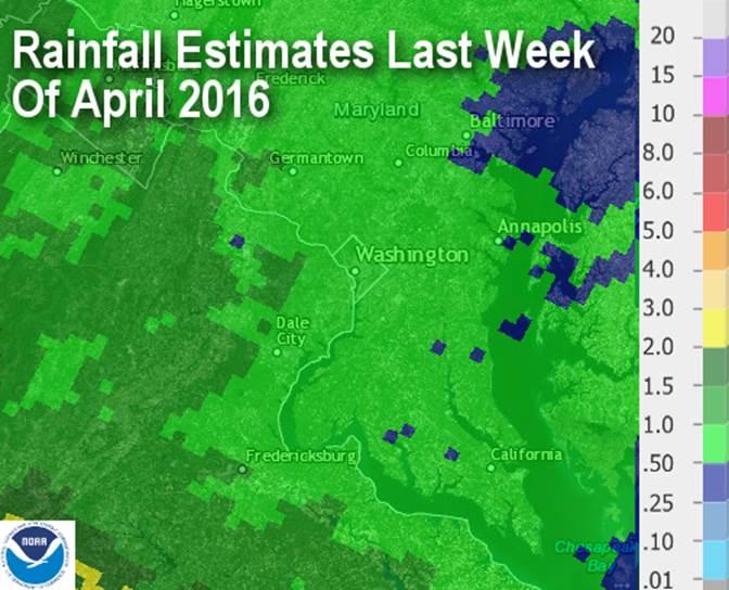
As of last week’s weather blog, the deficit for the year was 2.31 inches. The deficit since March 1 was 3.35 inches. As of 5 p.m. Sunday, the deficit for the year is down to 1.93 inches; the deficit since March 1 is down to 2.97 inches.
A lot of this deficit could be erased by this weekend.
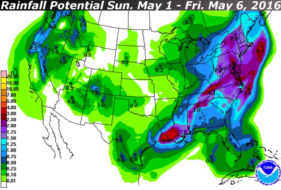
This next graphic is the forecast from the Weather Prediction Center for all the rainfall totals of all the systems between Sunday morning and Friday morning.
Editor’s note: This article is intended as an in-depth but plain-language discussion for the Washington area’s weather factors, ingredients and the uncertainties involved. For the latest Storm Team 4 Forecast details, check out the main WTOP weather page.