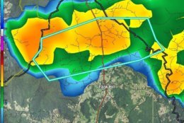
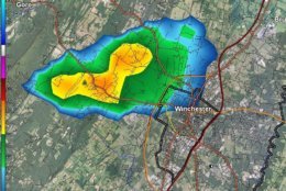
Doppler radar refectivity and 1-hour rainfall estimates over that small area of northern Rappahannock county and a little bit of Fauquier. Flash Flood Warning within the teal "polygon" until 5:15pm @wtop #nbc4dc #vawx pic.twitter.com/O8PwZOKpH0
— Met. Matt Ritter (@MetMattRitter) May 26, 2018
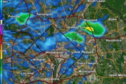
A few very small showers have developed right over the Beltway area. They won't move very quickly. Not growing very quickly, either. @wtop #dcwx #mdwx #vawx pic.twitter.com/Jr4JzcIe0K
— Met. Matt Ritter (@MetMattRitter) May 26, 2018
Another look, everything in western sections and pretty isolated, small. Sloooow moving, too. pic.twitter.com/UaZGKL120q
— Met. Matt Ritter (@MetMattRitter) May 26, 2018
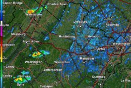
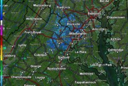
As if on cue, a growing thunderstorm near #winchesterVA The I-81 corridor is the most likely area for the scattered storms to form this afternoon that will then drift to the east into the heart of the #wtop listening area. pic.twitter.com/n9kfqkpL0V
— Met. Matt Ritter (@MetMattRitter) May 26, 2018
Definitely "hurry up and wait" for scattered storms today. Atmospheric "lid" not broken yet, but clouds are building. Most of us won't get rained on today and those who do will only have temporary nuisance storms. Better chance Sunday afternoon/evening - still sctd. #wtop pic.twitter.com/ELALcdu6cs
— Met. Matt Ritter (@MetMattRitter) May 26, 2018
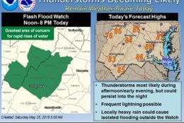
Thunderstorms will become increasingly likely across the area this afternoon and evening. Heavy rainfall may cause a few instances of flash flooding. Frequent lightning will also be possible. Have a plan to shelter if you are outdoors today. pic.twitter.com/Xa1j2BUFr6
— NWS DC/Baltimore (@NWS_BaltWash) May 26, 2018
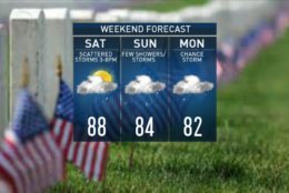
Here's your Memorial Day weekend forecast.
— Amelia Draper (@amelia_draper) May 25, 2018
We'll be hot and humid all weekend long.
Best chance of sun: Saturday AM/midday
Best chance of rain: Sunday
Best chance to stay completely dry: Memorial Day
Similar at the beach but 70s vs 80s
Stay wx ready! pic.twitter.com/DwqJJNdmHi
WASHINGTON — Saturday has been hot and humid with storms and showers rolling into the D.C. area, causing flooding and prompting weather warnings.
Quick Links:
Following the rain in the late afternoon, the D.C.-area saw severe weather in isolated areas, prompting warnings from the National Weather Service.
NWS issued a severe thunderstorm warning for Prince George’s County and Montgomery County in Maryland, and in Southwestern Culpeper County in Virginia.
NWS issued a flash flood warning for Fauquier and Culpeper counties and north central Rappahannock County in Virginia.
The D.C. area and areas to the north saw showers and a few thunderstorms.
Thunderstorms will become increasingly likely across the area this afternoon and evening. Heavy rainfall may cause a few instances of flash flooding. Frequent lightning will also be possible. Have a plan to shelter if you are outdoors today. pic.twitter.com/Xa1j2BUFr6
— NWS DC/Baltimore (@NWS_BaltWash) May 26, 2018
Although there was not a severe threat, heavy, blinding downpours were a primary concern that could lead to localized flooding, as Storm Team4’s Somara Theodore had forecast.
The threat of rain will linger throughout the D.C. area for much of the weekend, but the good news is the weather will be a bit cooler. Temperatures will top out in the mid 80s for the most part.
Theodore said that Monday looks like the best day of the holiday weekend, with temperatures in the low 80s and some sun, although there is still the chance for rain.
If you’re planning on traveling out of the D.C. area to the Gulf Coast, a storm could wind up causing some travel problems.
The National Hurricane Center said tropical storm conditions might wind up reaching parts of the Gulf Coast as soon as midday Sunday. This is due to Subtropical Storm Alberto, which could strengthen over the course of the weekend.
Alberto is the first named storm of the 2018 Atlantic hurricane season, which doesn’t officially start until June 1.
You can track the storm on the National Hurricane Center’s website.
Storm Team 4 Meteorologist Chuck Bell said depending on what track the storm takes, it could have an impact on the weather in the D.C. area by the second half of next week in the form of soaking rains and potential flooding.
Beach Forecast
Rain is in the forecast for most of the beaches close to the D.C. area as well.
You can check the current beach weather and traffic conditions on WTOP’s weather page.
Western Shore
On Sunday, highs will be in the low 80s with a higher chance of rain. On Monday, morning storms are possible, with highs near 80 degrees.
Ocean City
Thunderstorms are in the forecast for Sunday and Monday, with expected highs near 80 degrees.
Virginia Beach
Sunday will be partly cloudy, with a stray thunderstorm and a high of 87 degrees. Monday will be cloudy and rainy with a high of 83 degrees.
Rehoboth Beach, Delaware
Thunderstorms are expected to continue on Sunday and Monday with highs near 80 degrees.
Bethany Beach, Delaware
Thunderstorms are expected on Sunday and Monday. The expected high on Sunday will be 85 and 79 degrees, and 75 degrees on Monday.
Duck, North Carolina
On Sunday, the high is also expected to reach 84 degrees with more clouds than sun. Monday will see temperatures dip a bit below 80 with periods of rain.
Weekend Forecast
Sunday: Mostly cloudy with thunderstorms possible, but not a complete washout. High is expected to be around 87 degrees.
Monday: Mostly cloudy, a bit cooler with scattered showers possible. The rain is most likely to fall south of D.C. Highs are expected to be in the low to mid-80s.
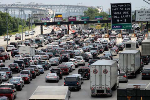
Traffic
Regardless of weather, there will be several parades and road closures that will impact travel on the holiday weekend.
AAA Mid-Atlantic said a record number of travelers are expected to hit the road this weekend.
For the most updated traffic report, visit WTOP’s traffic center. You can see a map of the latest traffic conditions below.
Radar
For the most updated traffic report, visit WTOP’s traffic center. You can see a map of the latest traffic conditions below.