Workweek weather: Cool, dry conditions roll in for week ahead

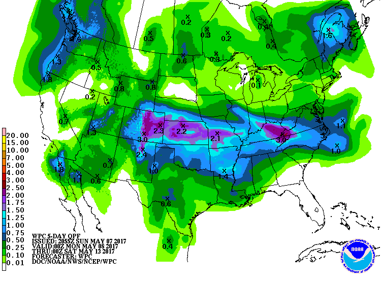
WASHINGTON — The storm system that brought the rain and thunderstorms at the end of last week — followed by lingering showers Saturday and Sunday — were all the result of a blocked-up weather pattern that was establishing itself called an Omega Block.

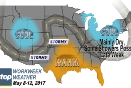
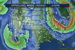
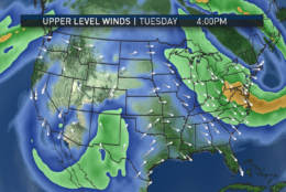
It gets its name from the shape of the jet stream winds, resembling the capital Greek letter Omega (Ω). It’s definitely a bit jargon-y, but it’s worth mentioning because they’re fairly common in the spring and they can last for days and days, if not weeks. You may recall we had one last year, but it was in April and it brought us different types of weather. This time around, we are also going to be mainly dry, but we are going to be on the cooler side of the setup.

An example of an Omega Block: two troughs of low pressure bookending an amplified ridge of high pressure, similar to the pattern we have right now. (National Weather Service — Southern Region, NOAA)

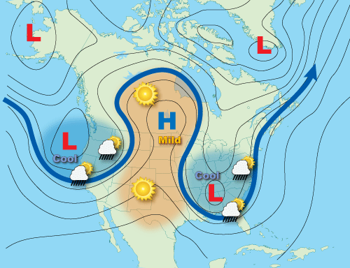
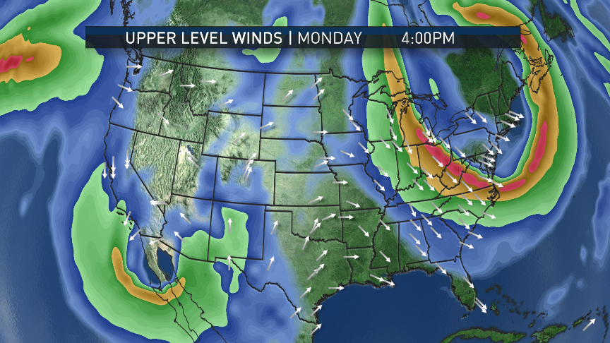
A bit blocking area of high pressure is over the north Atlantic right now, which has caused a deep dip, or “trough,” to develop in the Northeast and the mid-Atlantic, resulting in a flow of unseasonably cool air to spill down from Canada, air that is especially cold in the upper levels. This resulted in lots of instability and the unsettled weather over the weekend.

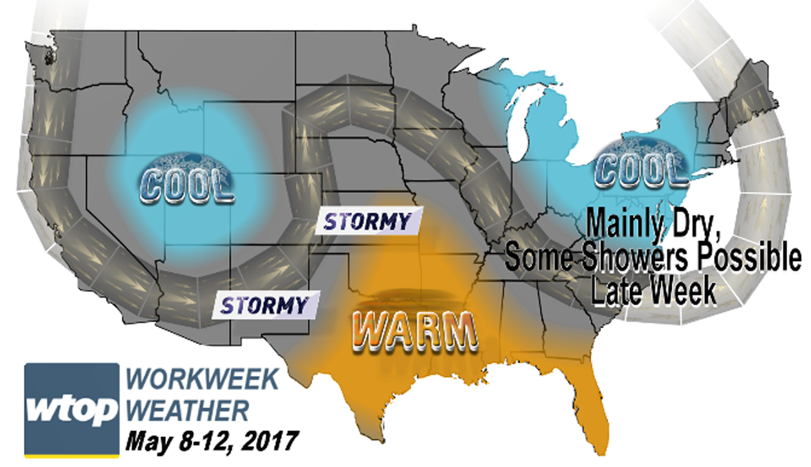
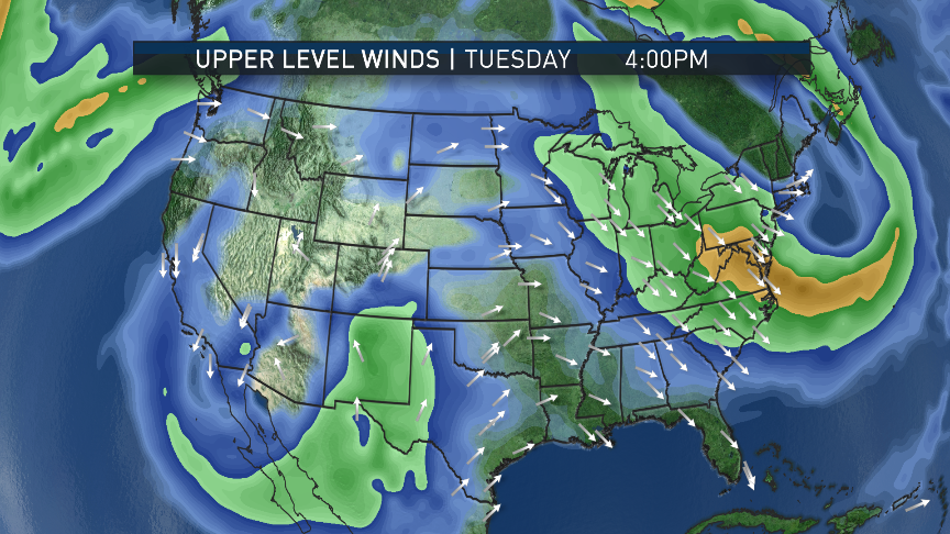
At the beginning of the new workweek, it will be less unstable during the daytime since we have dried out the low levels quite a bit. This will keep our temperatures cooler than average for several days, but with less cloud cover and chances for scattered showers or drizzle. Various computer models are probably too optimistic in making it too sunny for the first half of the week, but at this point, the clouds should be mainly scattered around.

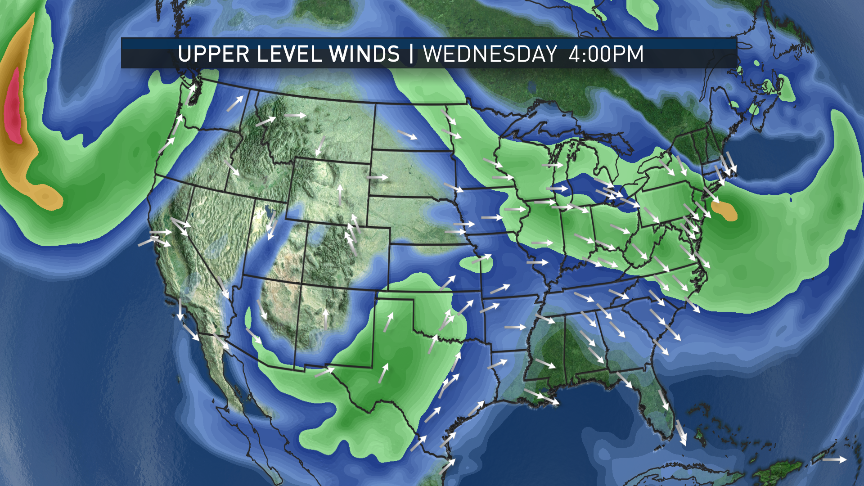
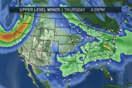
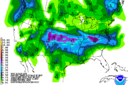
The key characteristic about these blocked patterns is that, well, they’re blocked, so not a lot changes day-to-day. The differences will be subtle this week with only a slow increase to seasonable temperatures not until Wednesday. A warm front trapped in the block will send rain and thunderstorms into the Midwest, but it will take some time for them to get here.

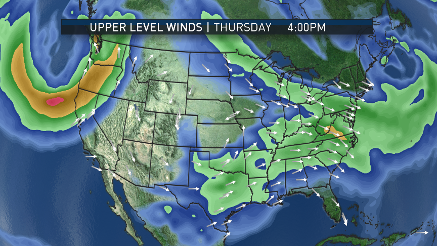
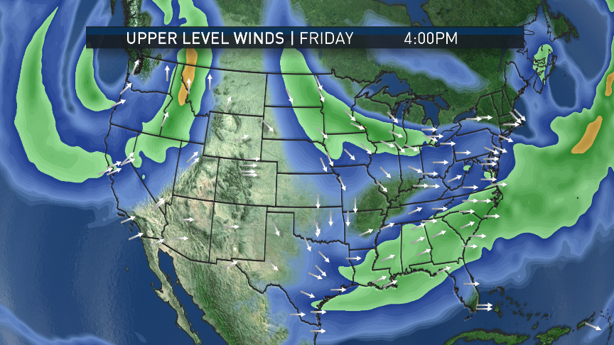
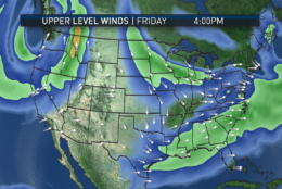
The pattern will break down, if only temporarily, as we get near to the end of the workweek, and a storm system will finally be able to eject out of the Plains, sending clouds and possible showers our way. But they may also last into the upcoming weekend. And some of the longer-range models suggest we could end up right back in another block next week.

If this “pattern of patterns” does persist the rest of the month, it’s highly unlikely we’ll see very many warm weather records of any sort like we did in April of this year.

Of course, we could still use some more rain, but the “Battle of the Beltways” is on this week, and it looks like the weather won’t interfere until Thursday at the earliest. However, some of the evenings will be fairly cool.

(WTOP/Storm Team 4)
You may recall we had an Omega Block last year, but it was in April and it brought us different types of weather. This time around, we are also going to be mainly dry, but we are going to be on the cooler side of the setup. (WTOP/Storm Team 4)
(Data: Environmental Modeling Center, NOAA. Graphics: Storm Team 4)
The next five images are snapshot depictions of the jet stream winds this week in the American GFS computer model. The strongest wind speeds are in the green-to-yellow colors and the arrows show the direction. Note the dips (“troughs”) on the two coasts and the ridge in the middle of the country. Definitely a crude resemblance, but there’s the Omega. By midweek, it’s flattening out a little bit, allowing a storm system to head our way for Friday or possibly Thursday at the earliest. (Data: Environmental Modeling Center, NOAA. Graphics: Storm Team 4)
(Data: Environmental Modeling Center, NOAA. Graphics: Storm Team 4)
The strongest wind speeds are in the green-to-yellow colors and the arrows show the direction. Note the dips (“troughs”) on the two coasts and the ridge in the middle of the country. Definitely a crude resemblance, but there’s the Omega. By midweek, it’s flattening out a little bit, allowing a storm system to head our way for Friday or possibly Thursday at the earliest. (Data: Environmental Modeling Center, NOAA. Graphics: Storm Team 4)
(Data: Environmental Modeling Center, NOAA. Graphics: Storm Team 4)
As mentioned, temperatures will be a bit cool this week, feeling more like the beginning-to-middle of April. Wednesday has the best chance for average numbers. Here’s the temperature forecast also from the GFS model. (Data: Environmental Modeling Center, NOAA. Graphics: Storm Team 4)
(Weather Prediction Center, NOAA)
The precipitation forecast for the workweek shows most of the showers and storms occurring in the Plains and Midwest, when the storm system in the West starts to shear to the East in the middle of the week. Our rainfall amounts are fairly meager and our totals are really only valid for Thursday night through Friday. Amounts are in inches. (Weather Prediction Center, NOAA)
(1/12)
(WTOP/Storm Team 4)
(Data: Environmental Modeling Center, NOAA. Graphics: Storm Team 4)
(Weather Prediction Center, NOAA)

Daily weather highlights 
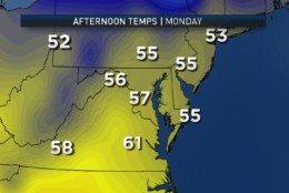
MONDAY
• Clear and very chilly start
• Mostly sunny in the morning
• Fair weather fluffy clouds throughout the afternoon
• Cool and breezy
• Highs around 10-15 degrees below average
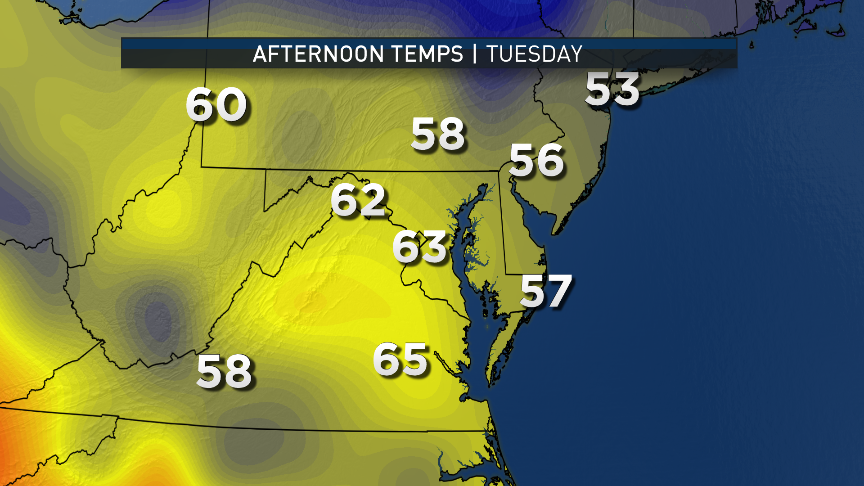
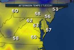
TUESDAY
• Clear and very chilly start
• Mostly sunny in the morning
• Fair weather fluffy clouds throughout the afternoon
• Not quite as cool or breezy, but still below average
• Highs about five degrees higher than Monday
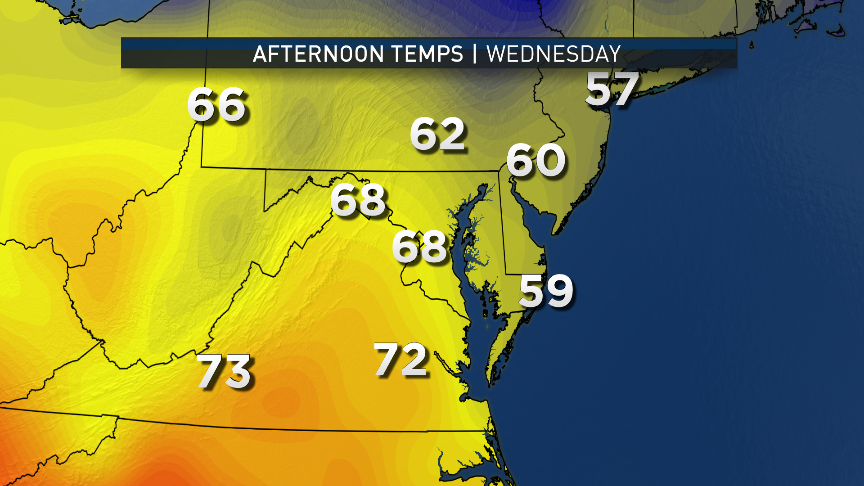
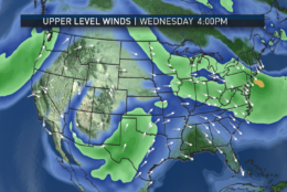
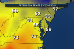
WEDNESDAY
• Cool start
• Lots of high-level clouds showing up in the western sky
• High temperatures closer to averages, this time just below averages
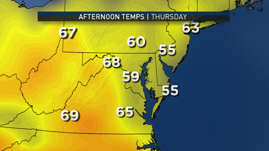
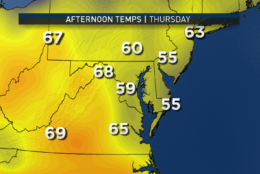
THURSDAY
• Much milder start
• More clouds than sun
• With limited sunshine, back to several degrees below average
• Keeping an eye on possible earlier arrival of showers
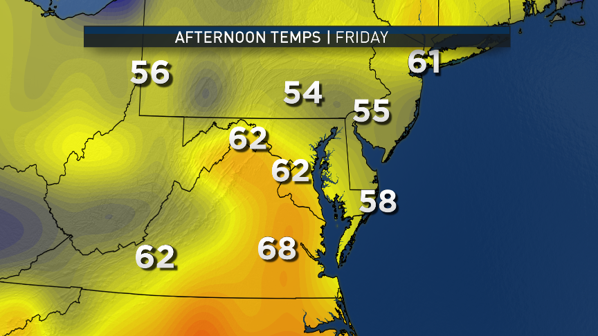
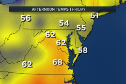
FRIDAY
• Overcast and chilly
• Very good chance of showers
• High temperatures well below average again


Editor’s Note: The WTOP Workweek Weather Blog is intended as an in-depth yet plain language summary of the business week’s weather potential in the D.C. area along with an explanation of the contingencies and uncertainties that exist at the time of publication. For the latest actual Storm Team 4 forecast, check out the main WTOP Weather Page.

Federal News Network Logo
Log in to your WTOP account for notifications and alerts customized for you.

Sign up