Editor’s Note: This article is intended as an in-depth but plain language discussion for the Washington area’s weather factors, ingredients, and the uncertainties involved. For the latest Storm Team 4 Forecast details, check out the main WTOP Weather Page.
WASHINGTON — Around this time last week a stalled weather pattern known as an “Omega Block” was setting up across North America. It gets its name for its shape, resembling the capital Greek letter Omega. More on the actual pattern later.
You’ve more than likely noticed the weather has only changed slightly in the past week and didn’t really start changing until the weekend, when it started getting a little warmer. But it’s still just as dry. We could use some rain but it does not look like there are any real chances until Friday when the Nationals return home.
When this weather pattern established itself, an area of high pressure at the surface was settled over eastern Canada and New England. High pressure was anchored over the Pacific Northwest, and storminess developed in the middle of the country. Our winds were primarily out of the north and were very dry. The ground has also been dry. This resulted in the slightly cooler than average daytime highs, but especially caused the cold nights.
That high pressure center is now located south of us, so the winds at the surface are changing direction and taking on a more westerly component (that means out of the west). That’s the biggest change which helped temperatures warm up over the weekend.
This Monday and Tuesday that westerly wind regime will be even more pronounced, resulting in even warmer temperatures. At the most, we would just see some thin, high level wispy clouds overhead. Other than that, there aren’t a lot of details: warm, sunny, quiet and pleasant.
But on Tuesday this Omega Block will finally start to break down. A weak cold front at the surface will be pushed through our region by another strong Canadian high pressure system. With very little atmospheric moisture to work with, Storm Team 4 is pessimistic about chances for showers, despite some computer models advertising some.
It’s more likely we will barely get mostly cloudy skies out of the front. But the winds will change direction again and start coming at us from the north, cooling us down for midweek, but only to more seasonable levels.
On Thursday, the remnants of the storm system from the Plains will start heading our way, as low pressure gets absorbed by the main jet stream steering winds. A large area of moisture will be sent our way ahead of a cold front. By the time that area makes it here, it may just be scattered showers and not a soaking rain. But since it’s mostly the topsoil that’s dry right now, it will still help.
Workweek highlights
Monday:
• Near total sunshine
• Unseasonably warm
Tuesday:
• Clear early before some clouds roll in late in the day
• More than likely no showers
• Feeling like summer but without the humidity
• Breeze picks up in the evening while temperatures drop
Wednesday:
• Sunshine and about as April as it gets (not counting all the missing “April showers”)
Thursday:
• Average temperatures
• Cloudy skies by nightfall
Friday:
• Cloudy but mild
• At least scattered showers with some measurable rainfall amounts
• Not likely to be the all-day inch of rainfall we could use
• Nats game may be playable but could have some delays
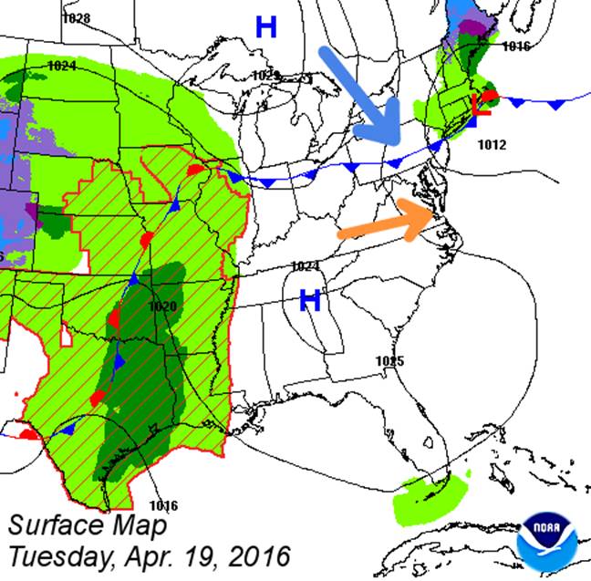
In this surface map graphic for Tuesday, notice our “old” area of high pressure giving way to the new area of high pressure over Canada, pushing the cold front through and changing the wind direction. However, it looks like the front goes through dry. All the stormy weather is still out in the Plains states, but it’s on the move while the pattern changes.
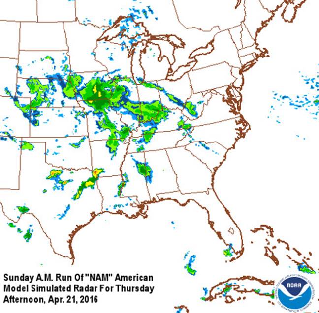
This next graphic is a model representation of future radar. Low pressure in the Plains is shearing out while it gets pulled into the Jet Stream. The area of precipitation is large, but it’s scattered and not particularly heavy. Bands of showers are already potential knocking on our door Thursday night.
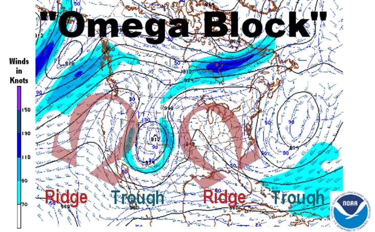
Now, a little bit more on the pattern known as an Omega Block. It is, as its name implies, a blocked weather pattern. They don’t always happen every early spring, but when they occur, this is usually the time. Although winds aloft themselves are moving, the weather systems at the surface don’t appear to be moving much. That is to say, they’re not getting steered across the continent.
The type of weather one sees when an Omega Block starts will generally be the same weather for days on end — if not literally weeks on end in some cases. When one looks at the shape or the orientation or troughs (dips) of low pressure and ridges (hills) of high pressure, a series of them are close together and resemble links of the Greek capital letter, Omega.
The next graphic was the orientation of the upper level winds on Sunday morning. Admittedly it looks a little crude, but it’s from actual data. The Omega letters are superimposed near the shapes of the ridges to which they correspond.
When these Omega Blocks fall apart, the troughs of low pressure lose their closed circulations and weaken. Then they get absorbed into the main westerlies, awaiting the next pattern to establish itself.