Workweek weather: More 80-degree weather, rainfall, possible

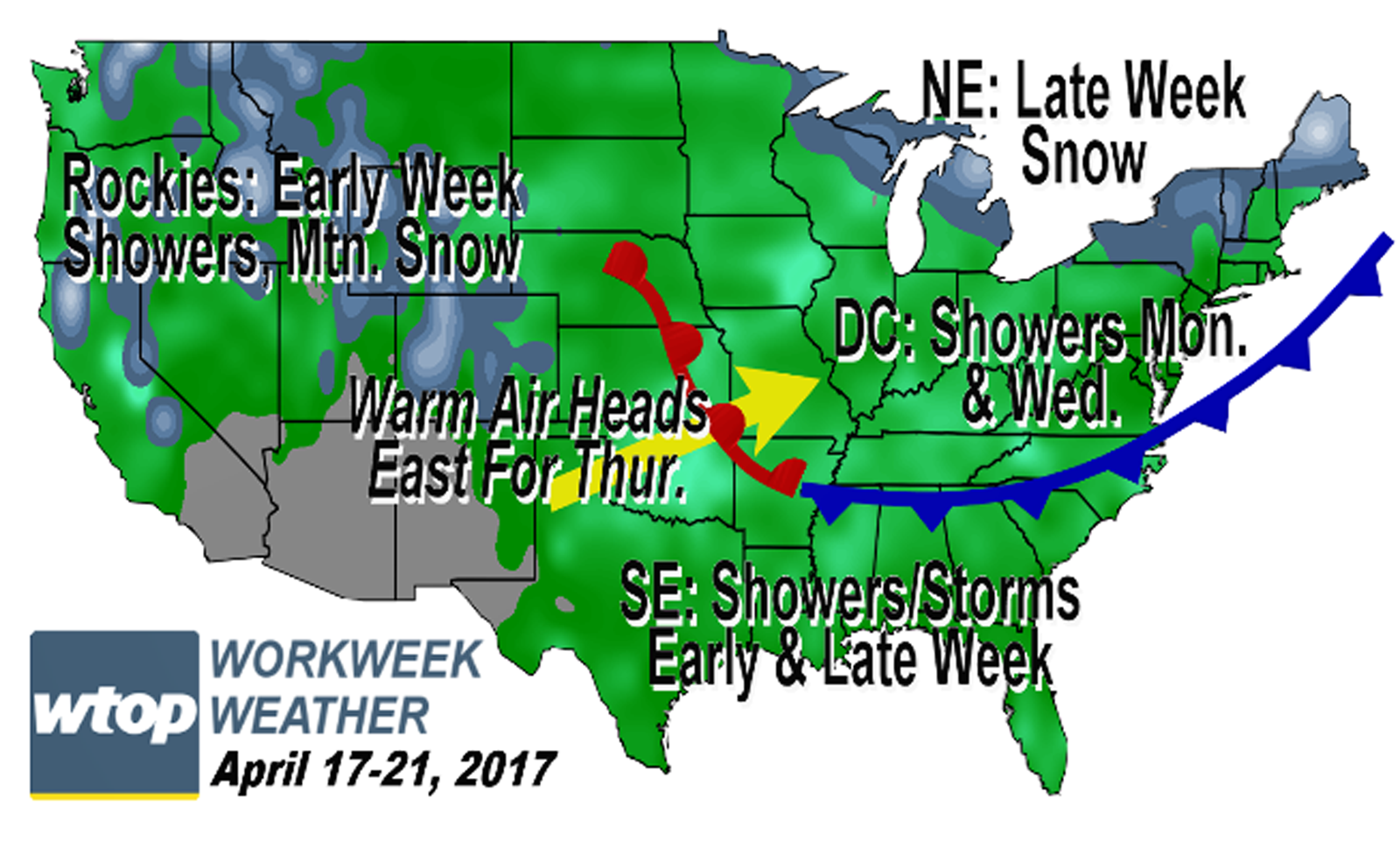
WASHINGTON — A typical spring week is ahead of us with temperature swings and some chances of rainfall.

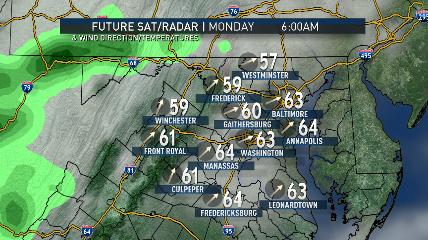
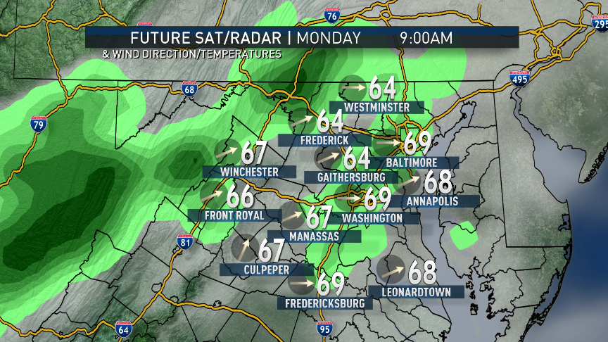
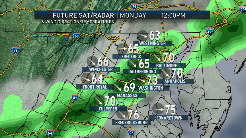
A cold front was marching through the area with a line of showers and thunderstorms behind it at the time this article was published. This front will keep the very warm temperatures we had on Easter Sunday confined to one day, but the front will return midweek as a warm front, bringing a return to the very warm weather for a day, possibly two.

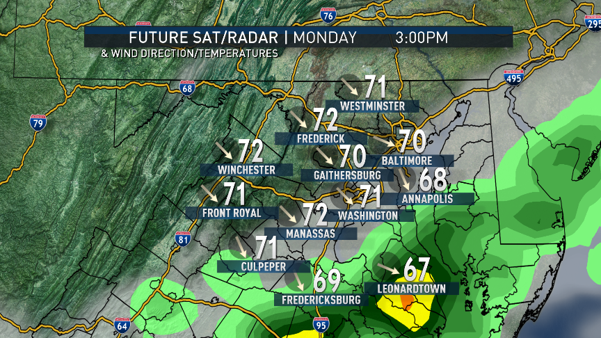
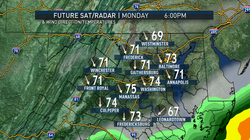
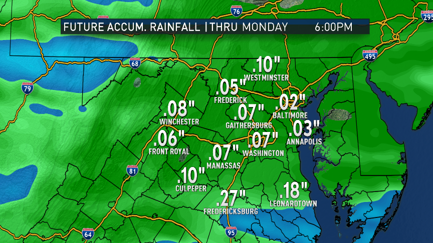
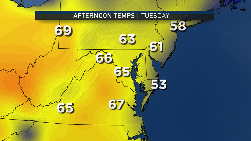
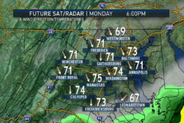
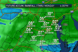
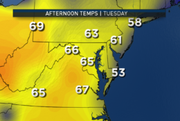
The scattered showers and possible thunderstorms will slide through the area early Monday until about midday, then depart to the south and east. We will likely have had our high temperatures for Monday just after midnight, before the front arrived. Temperatures will fall immediately behind the front and the showers, then will “spike” back up in the afternoon when the sun comes back out. But northwesterly winds will accelerate the cool down again in the evening and Tuesday will start out much cooler. High pressure will build over New England on Tuesday, keeping us in a mostly easterly flow. So despite sunshine, we will only end up slightly higher than average.

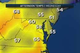
On Wednesday, the front will come back with clouds and a chance for some more showers. Because of the cool start to the day — the clouds, showers  and mostly easterly flow — temperatures may end up slightly below average. A lot depends on the exact timing of the front: If it slows down, it will take longer for showers to get here and we may end up mild. It’s not likely that we’ll end up cooler than forecast, however. As the warm front passes to our north, we’ll be in the “warm sector” of the storm system again, much like we were on Sunday. This will likely result in temperatures well above average again, likely in the low 80s.

A lot will depend on exactly how much sun we get. Then a wave of low pressure along the frontal boundary will swing it our way again as a cold front, and Friday will end up being a day of transition from warm to cool, if not just back to average for the weekend. But if that front ends up being slower than anticipated, Friday could end up being much warmer and the cool down will wait for Saturday.

The Washington Nationals are out of town all week and may have to deal with some thunderstorms in Atlanta.

A typical spring week is ahead of us with temperature swings and some chances of rainfall.
 (WTOP/Storm Team 4)
A typical spring week is ahead of us with temperature swings and some chances of rainfall. (WTOP/Storm Team 4)
The RPM computer model simulation of clouds and radar shows the likely progression of the front, its showers and the effect on wind direction and temperatures going through the day on Monday. Notice the mild start, the cool down, the clearing and the temperature rebound in the afternoon sunshine.
 (Data: The Weather Company | Graphics: Storm Team 4)
The RPM computer model simulation of clouds and radar shows the likely progression of the front, its showers and the effect on wind direction and temperatures going through the day on Monday. Notice the mild start, the cool down, the clearing and the temperature rebound in the afternoon sunshine. (Data: The Weather Company | Graphics: Storm Team 4)
And how does it all add up for rainfall? Not much. Likely a tenth or less, much less than what we need to wash away some pollen and further alleviate the drought. The showers projected for Wednesday will probably have twice the amount of rainfall. (Data: The Weather Company | Graphics: Storm Team 4)
As far as the rest of the week, the American GFS model shows the cooler weather for Tuesday, the variability on Wednesday depending on the speed of the warm front and its clouds and showers. Also, the big warm up for Thursday (the model has been too cool with temperatures south of the warm fronts lately). And notice the big contrast on Friday along the next cold front. Lots of uncertainty this early in the game for Day 5 and the hour-by-hour progression of the front. (Data: Environmental Modeling Center, NOAA | Graphics: Storm Team 4)
(1/11)
A typical spring week is ahead of us with temperature swings and some chances of rainfall.
 (WTOP/Storm Team 4)
The RPM computer model simulation of clouds and radar shows the likely progression of the front, its showers and the effect on wind direction and temperatures going through the day on Monday. Notice the mild start, the cool down, the clearing and the temperature rebound in the afternoon sunshine.
 (Data: The Weather Company | Graphics: Storm Team 4)
And how does it all add up for rainfall? Not much. Likely a tenth or less, much less than what we need to wash away some pollen and further alleviate the drought. The showers projected for Wednesday will probably have twice the amount of rainfall. (Data: The Weather Company | Graphics: Storm Team 4)
As far as the rest of the week, the American GFS model shows the cooler weather for Tuesday, the variability on Wednesday depending on the speed of the warm front and its clouds and showers. Also, the big warm up for Thursday (the model has been too cool with temperatures south of the warm fronts lately). And notice the big contrast on Friday along the next cold front. Lots of uncertainty this early in the game for Day 5 and the hour-by-hour progression of the front. (Data: Environmental Modeling Center, NOAA | Graphics: Storm Team 4)

Daily weather highlights
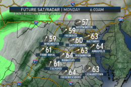
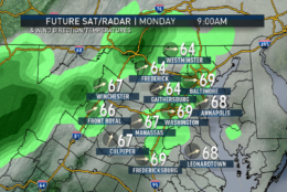
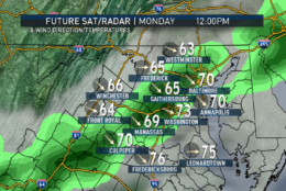
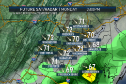
MONDAY
— Cloudy skies and a few ongoing showers/thunderstorms moving from north to south until early afternoon at the latest
— Breezy and warm to start, then cooler, then mild again in afternoon sun
— Turning sharply cooler again after sunset

TUESDAY
— Partly sunny; lots of thin, high-level clouds
— Easterly breezes
— Slightly milder than average
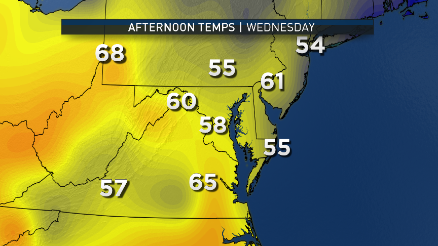
WEDNESDAY
— Cool start
— Clear skies early clouding over
— A few showers possible by the end of the day, lasting into the evening
— Seasonable temperatures, but the coolest day of the week
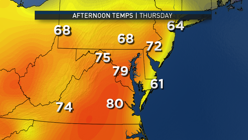
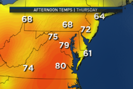
THURSDAY
— Clearing skies
— Breezy and becoming much warmer
— High temperatures likely getting into the low 80s
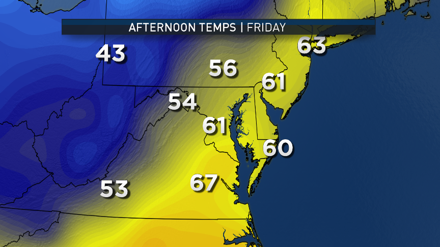
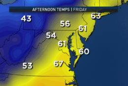
FRIDAY
— Lots of uncertainty at this point
— Either mostly cloudy with scattered showers ending and still warm OR
— Clearing early in the day and much cooler
— Big temperature differences possible from Pennsylvania line to southern Virginia and Maryland


Editor’s Note: The WTOP Workweek Weather Blog is intended as an in-depth yet plain language summary of the business week’s weather potential in the D.C. area along with an explanation of the contingencies and uncertainties that exist at the time of publication. For the latest actual Storm Team 4 forecast, check out the main WTOP Weather Page.

Federal News Network Logo
Log in to your WTOP account for notifications and alerts customized for you.

Sign up