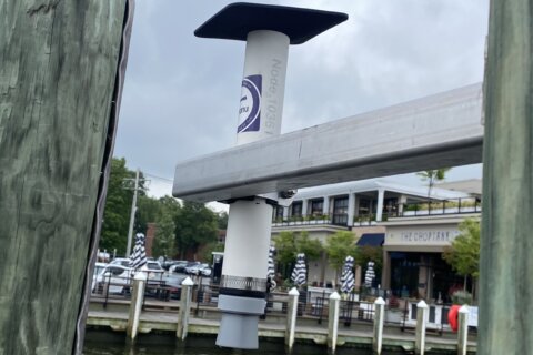

Hanging on a pilon along Ego Alley in Annapolis, Maryland, is what looks like a piece of PVC pipe with a small solar panel attached to it. There are more of them hanging around the city, and soon they’ll be up and down Anne Arundel County, as well as in Charles County, Baltimore City and throughout the Eastern Shore.
The new sensors, called the “Maryland HydroNet” and installed by the University of Maryland, will help local governments as well as those who live in flood prone areas track rising floodwaters in real time.
While the federal government already has instruments monitoring water levels, those sensors are extremely expensive, in the range of hundreds of thousands of dollars. These much more inexpensive local ones will help add to the information they collect.
Because they’re so much cheaper — though not as precise as the ones the National Oceanic and Atmospheric Administration uses — scientists will be able to install more of them all over the place, including smaller communities that get hit hard by flooding but have limited economic resources.
The Maryland HydroNet uses technology from a Hawaiian-based company called Hohonu. It’s CEO and founder is Brian Glazer, who is also a professor at the University of Hawaii.
“That’s the magic, making it cheap and easy and able to put out anywhere,” Glazer told community members gathered on the Annapolis City Dock on Wednesday morning. “The gray cone at the bottom is pinging, looking down at the water like a dolphin or a bat using sonar, and measuring that air gap distance. So as water comes up, or water goes down, it’s measuring that every second.”
Each sensor and the data support that comes with it costs less than $3,000 per year, and it can provide the sort of hyperlocal monitoring that was previously impossible to get. The sensor is now being used in 15 states around the country.
“It means mayors are waking up at 3 o’clock in the morning to a text message alert saying, ‘Well, I need to reroute ambulance traffic, I need to deploy flood barriers,'” Glazer said.
Pointing out an area that is constantly flooded, and nearly flooded again earlier that morning, Anne Arundel County Executive Steuart Pittman called Maryland “ground zero” for the impact of climate change and said this new tool will help the community.
“Having the sensors is real time information. Quick. And information that our Office of Emergency Management can actually respond to,” he added. “It’s data that can then be used for predicting future impacts.”
There are two sensors already installed in Charles County, which is also seeing more frequent flooding, said Reuben Collins, the president of the Charles County Commissioners.
“What this provides for our first responders is more accessibility and ability to actually respond in real time, as opposed to waiting for the problem to reach the point where our residents are saying, ‘Look, we can’t even get out of our homes, or we can’t get back in our homes,'” Collins said. “We see this directly. We see the impact of what climate change is actually doing to our community.”
The flood sensor program is being run by Tim Canty, an associate professor of atmospheric and oceanic science at the University of Maryland.
“We don’t have a choice. We can’t turn our back on rising sea levels and hope for the best,” said Canty.
He said the sensors, which collect the data and then send out it via cellular technology, are plug-and-play simple.
“We’ve got one sensor near Cobb Island to help with them understanding the flooding leading into Cobb Island,” Canty said. “They have to station paramedics on Cobb Island before the bridge entrance floods. So now, we’re providing data in that area to give them kind of a heads up when that’s happening. We have sensors planned for the Deale Peninsula, because that’s had high flood risk. Downtown Baltimore has flood risk as well. We have a lot of places we want to start moving into.”
And because Hohonu puts all the data on a mobile app, it’s accessible to anyone, not just emergency and government leaders.
“This is all publicly available data,” Glazer explained. “You can log on. You can sign up for a text message alert when you get to a critical threshold of water level that’s important for you.”
Get breaking news and daily headlines delivered to your email inbox by signing up here.
© 2024 WTOP. All Rights Reserved. This website is not intended for users located within the European Economic Area.