While the 2022 Atlantic hurricane season is on pace to be an average season, the Washington metro area has been spared any significant deluge and high winds. With a system on the horizon for the eastern U.S. next week, let’s see how much of an impact November tropical systems have on D.C.’s weather.

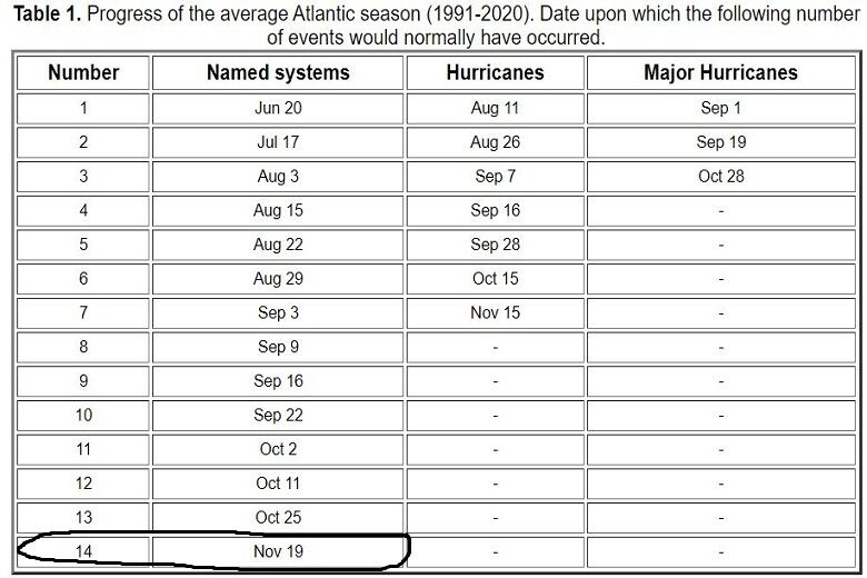
Thirteen named storms have formed so far this season within the Atlantic basin, with Lisa and Martin being the most recently named tropical systems. Historically, the fourteenth named storm forms around November 19.
This year, a disturbance in the Eastern Caribbean is showing signs of giving us the next named system of the season.
Tropical water temperatures in the lower 80s more than support that development, with low wind shear in favor of the system becoming at least a tropical storm by early next week. As it eyes the East Coast, it will be named either Nicole or Owen, depending on whether another low-pressure system east of Bermuda (not a threat to the U.S.), becomes a named storm first.
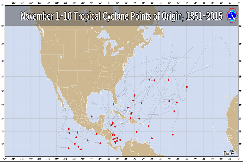
Historically, early November storms develop in the southern Atlantic and Caribbean where water is warmest and track either along, or offshore the East Coast. While it’s not unusual for Florida to be in the crosshairs of a November tropical storm or hurricane, it’s very rare for one to sweep directly through the Mid-Atlantic. They are more likely to stay offshore of the Delmarva coast.
How have previous tropical systems impacted our area in November?
First of all, the earliest recorded storm of the season where the Washington area saw high winds, heavy rain and notable damage was on Oct. 23, 1878. On that date, a Category 2 hurricane with maximum sustained winds of 96 to 110 mph slammed D.C. on that date.
This storm was not named (naming of tropical storms and hurricanes didn’t begin until 1953), but this particular hurricane was the strongest storm to hit the D.C. area since official record keeping began in 1851.
In a typical November pattern, frequent frontal systems will push across the D.C. region and moisture from a tropical system might enhance rainfall along the front. For us, these systems typically don’t trigger flooding. The same fronts are also responsible for directing tropical storms and hurricanes east of D.C.
This was the case on Nov. 12, 2020, when a cold front’s moisture was enhanced by Tropical Storm Eta, which pushed from northern Florida to off the East Coast. Reagan National Airport registered 0.64 inches of rain, which was the only significant rainfall of the month.
Hurricane Kate, which was located well offshore the East Coast, was absorbed into a front that pushed through Washington on Nov. 9-10, 2015 and produced 0.77 inches of rain.
The meteorological pattern we’re seeing for late in the week shows a seasonably strong front pushing east from the northern Plains to the mid-Atlantic, while a likely tropical depression or tropical storm will careen across southern Florida.
The front will likely steer the tropical system north to the Gulf Coast and then northeast to off the East Coast by next weekend.
Washington will get beneficial rain from this front teaming up with tropical moisture, with amounts likely to range from 0.5 to 1.5 inches. The only minor flooding risk comes from autumn leaves blocking the storm drains.
Otherwise, the region will remain unscathed from any tropical threats and rain will help end the recent dry streak. The winds will become breezy, but likely not strong enough to produce any power outages.
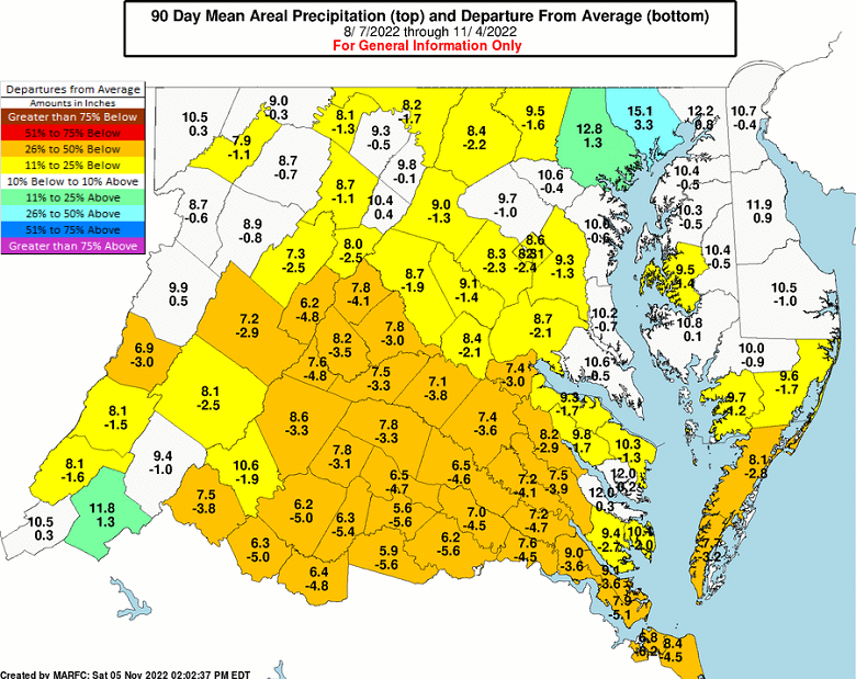
Reagan National Airport averages 2.91 inches of rain in November. This moisture coming early next weekend is much needed since deficits in the last three months have reached 2.4 inches and area rivers are running low.