The D.C. area isn’t done with winter weather for the month of January yet, as the forecast calls for a snowstorm that will transition to freezing rain on Sunday, and a state of emergency has been declared in Virginia. Here’s what you need to know.
- Snow, sleet and freezing rain will roll through the area starting Sunday, with the hardest-hit areas possibly getting up to 10 inches of snow.
- Storm Team4 Meteorologist Chuck Bell said people should avoid traveling Sunday afternoon through Tuesday morning.
- Gov. Ralph Northam has declared a state of emergency to help agencies prepare for the storm. He made the decision after conferring with Governor-elect Glenn Youngkin, who takes office Saturday, and his team.
- Area road crews are already preparing roads.
- Utility companies are working to avoid a repeat of the outages that plagued the area earlier this month.
Starting around noon
Snow will start to move into the western and southern suburbs around noon Sunday, covering the entire region during the afternoon.
“There could be several inches of snow by sunset,” Storm Team4 meteorologist Mike Stinneford said.
Eventually, the precipitation will change over to sleet, freezing rain and then rain Sunday night. Precipitation may remain mostly snow near the Blue Ridge throughout this event.
Winter Storm Watch now in effect Sunday afternoon and Sunday night for locations near and west of U.S. Route 15. Heavy snowfall and ice is possible further east, but confidence remains lower — however, the watch could be expanded if that changes. Be ready for winter wx Sunday pic.twitter.com/QnB3AKJw26
— NWS Baltimore-Washington (@NWS_BaltWash) January 14, 2022
The National Weather Service issued a Winter Storm Watch effective Sunday afternoon until Monday morning for Washington and Frederick counties in Maryland; and Rappahannock, Culpeper, northern Fauquier and western Loudoun counties in Virginia.
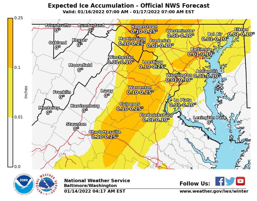
The NWS said heavy snow is possible in those areas, with total snow accumulations of 5 to 8 inches the most likely, and up to 10 inches possible. Ice accumulations of one- to two-tenths of an inch are possible too. Winds could gust up to 40 mph.
The storm will then move up along Calvert and St. Mary’s counties in Maryland and through D.C. Sunday night, with rain for the majority of the region, which can knock down the amount of snow accumulating on the ground. Some areas are expected to receive freezing rain, sleet or even more snow before the system leaves on Monday morning.
The NWS predicts the snow will fall one to 3 inches per hour in the late afternoon and evening Sunday, making “nearing impassable roads.” Storm Team4 Meteorologist Chuck Bell said people should avoid traveling Sunday afternoon through Tuesday morning.
Bell said most of the Interstate 95 corridor will get 3 to 4 inches of snow before the transition to sleet or rain.
Virginia Gov. Ralph Northam on Friday declared a state of emergency in the commonwealth because of the oncoming storm. “Declaring a state of emergency now allows our emergency responders to prepare, and to move supplies and equipment where they expect to need them the most,” Northam said in a statement. “This also gives Governor-elect Youngkin the ability to respond to any storm needs swiftly. I urge Virginians to take this storm seriously and make preparations now.”
Northam and state emergency officials talked Friday morning with Youngkin, who takes office Saturday, and his team.
Some good graphic loops for Sunday’s storm. Yes, it will be a high-impact event. No, it will not be the biggest storm in DC history. Coming on a Sunday afternoon and heading into a Federal holiday on Monday will really help road crews … a lot. https://t.co/d4rMvQDhuv
— Chuck Bell (@ChuckBell4) January 14, 2022
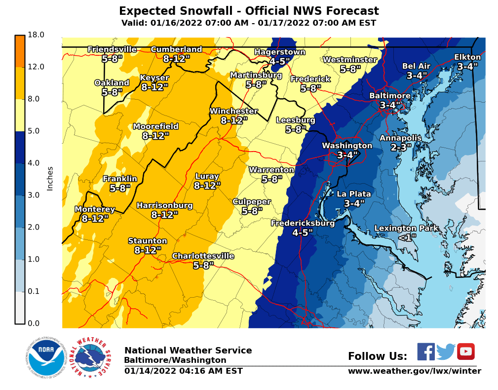
Areas west of the Blue Ridge, West Virginia and Northern Maryland will get the most snow, with 8 to 12 inches possible.
Bell said that there are still many areas of uncertainty in this forecast, but confidence continues to increase on the timing and the impact.
Commuters working on Dr. Martin Luther King Jr. Day should plan for the snow to refreeze overnight Sunday, which could make for dangerous driving conditions Monday morning.
- Listen to WTOP online and on the radio at 103.5 FM or 107.7 FM.
- Current traffic conditions
- Weather forecast
- Closings and Delays
- Sign up for WTOP alerts
Preparing roads for another round of snow
In the effort to avoid another travel nightmare as experienced a week ago by some drivers stuck on I-95 for more than 24 hours, D.C., Maryland and Virginia have began taking action before the snow arrives.
Road crews sprayed a salt brine solution on both sides of I-95 Thursday between Joplin Road in Prince William County to Caroline County. According to the Virginia Department of Transportation, the solution will prevent ice from bonding into the pavement during the storm, reducing the risk of hazardous road conditions while helping crews with snow and ice removal.
Crews continued to apply pretreatment on as many roads as possible on Friday, including in Fredericksburg, the Northern Neck and Middle Peninsula. VDOT said drivers may see daytime delays on various routes during the “slow-moving operation.”
“The brine trucks travel at slower speeds to spray the salt brine solution onto the road with precision and to ensure an adequate amount is absorbed in the pavement,” VDOT said.
Once 2 or more inches of snow have accumulated, Virginia’s online snowplow tracker is activated, and users can monitor the status of roads, as well as where snow plows are working. Maryland has a similar interactive tool online.
D.C. started applying a salt brine to the roads Thursday night, according to Chris Rodriguez, head of the District’s Homeland Security and Emergency Management Agency. Crews finished in D.C. around 7 a.m. Friday but applied more salt treatment over the course of the day.
Rodriguez told WTOP the Department of Public Works and the Department of Transportation are going to be at full deployment for the winter storm.
“We have up to 400 plows available both through the government and also our contract plows. So we are prepared and we can shift our operations if we need to, if the forecast changes,” Rodriguez said.
The Maryland Department of Transportation said crews are applying an anti-icing brine to the roadways and are encouraging drivers to avoid or delay travel during the storm, if possible.
Areas without residual salt from the last storms were treated earlier Friday, according to Maryland State Highway spokesperson Sherry Christian.
Christian said drivers should continue to follow the “basic guidelines.”
“But when you’re in inclement weather, you need to take it down a notch,” Christian said. “So slow down. Remember the posted speed limits are for ideal weather conditions, which is what this storm is not.”
Christian recommended people drive at least 10 mph below the speed limit, use caution around snow plows and clear all snow off of vehicles before driving.
Drivers are also asked to avoid unnecessary travel, due to the possibility of dangerous weather and road conditions during and after the storm. VDOT encouraged college students to either arrive early to campus or delay their travel, as many start their spring semester this week.
This weekend’s #WinterWeather will impact students returning to college campuses. Those with travel plans are encouraged to monitor forecasts for the entire route & return prior to the storm or delay travel. Travel on Sunday is not advised.
❄ Learn more: https://t.co/PtVdDF9D9s pic.twitter.com/VERrAxKkxF— VDOT (@VaDOT) January 13, 2022
“The best news with this storm is the timing,” Storm Team4 meteorologist Doug Kammerer said. “We’re looking at Sunday night into very early Monday morning. And of course, [with] Monday being a holiday, a lot less people on area roads.”
Virginia electricity company prepping for outages
Besides slick roads, storms earlier in January also brought power outages to the D.C. area as winds, snow and freezing rain damaged power lines.
If the storm brings wet snow, Casey Hollins, a spokesperson for Rappahannock Electric Cooperative, said there could be similar challenges. But if the system changes and the snow is light and fluffy, it will have less of an impact on power lines.
Hollins said the company has proactively staged workers around their service territory in anticipation of Sunday’s snow. It’s all hands on deck with the cooperative readying 300 company employees, more than 100 Electric Co Ops workers and over 125 contractors and tree workers. The company website has a tool to report outages.
Dominion Energy will also have workers and contractors on standby for possible outages, according to Peggy Fox, a company spokesperson. Outages can be reported on the company’s app.
Sean Matthews, a spokesperson for PEPCO, said their crews are also prepping for snow in D.C., and Prince George’s and Montgomery counties in Maryland.
Matthew said outages can be reported online at the company’s website or by calling 877-PEPCO-62.
“If you do see an unsafe condition, whether it be a downed pole, or wire that’s come down, always treat that in that situation as if that wire is active and energized,” Matthews said. “Don’t touch it; stay away from it and give us a call.”
Across the board, power companies are monitoring the storm and ready to adjust their resources based on the forecast.
People should prepare any supplies needed for alternative heat sources; Hollins reminded people to have wood for fireplaces or gas for generators.
“The last storm created a lot of travel challenges,” Hollins said. “So if you don’t have those sources of heat to keep you safe, then we recommend thinking about where you might be able to go in advance.”
Other reminders that Matthew gave included charging up devices and checking emergency kits for water bottles, non-perishable food, battery powered radios, flashlights, first aid and medications.
Fox also said that Dominion Energy is aware of mixed messages on when power would come back after the last storm knocked down trees into roads and made it difficult to assess damage.
“Our goal is to provide accurate data based on what we know at any given point in time,” Fox said. This time, we will wait until we have more accurate information on damages before providing an individual ETR (estimated time to restoration).”
Forecast:
FRIDAY NIGHT: Fair, breezy and colder. Lows mid teens to lower 20s, with wind chills 5 to 15.
SATURDAY: Becoming cloudy. Windy and colder. Highs upper 20s to mid 30s.
SUNDAY: Snow developing around noon. Several inches of snow possible by sunset. Highs in the low to mid-30s.
SUNDAY NIGHT: Snow changing to ice and then rain. Precipitation staying mostly snow near the Blue Ridge. Steady or rising temperatures.
Current conditions:
WTOP’s Rick Massimo, Jose Umana, Andrew Alsbrooks, Abigail Constantino and Alejandro Alvarez contributed to this report.