Though we can still use more rain to make up our multiyear deficit, we are not going to get it this week. In fact, it looks like another preview of summer weather is on the way.
WASHINGTON — Last week certainly ended on a soggy note with rainfall that was so desperately needed. We can still use more to make up our multiyear deficit, but we are not going to get it this week. In fact, it looks like another preview of summer weather is on the way.
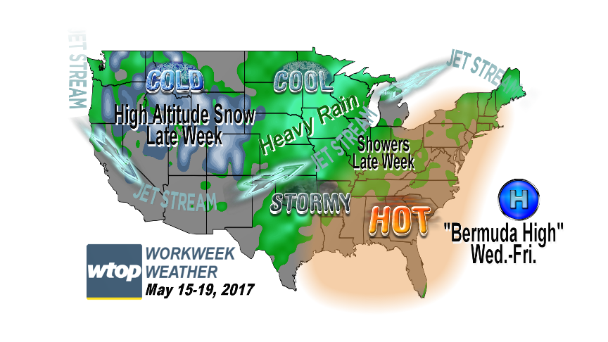
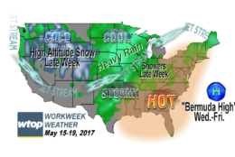
This week’s culprit will be like the last ones we had in March and April: a “Bermuda High,” a ridge of high pressure centered near Bermuda where the circulation sets up a deep, southwesterly flow pumping in heat — and even some humidity — up from the South.
Before this becomes a Bermuda High, it is going to start out like any other nice, pleasant, comfortable high pressure center coming at us from central Canada. The last remnants of the deep area of low pressure over the Northeast that was related to our soaking rain pattern from last week will be lifting out, and Monday and Tuesday will both have some pleasant, seasonable, sunny conditions. That’s when we will be in the northwest flow, our area in the clockwise circulation of the high.
It’s Wednesday into Friday that the circulation on the west side of the high will be acting as a “heat pump,” bringing in the very warm conditions. As mentioned, it will also be somewhat humid, since the circulation will be tapping some moisture from the Gulf of Mexico.
In this pattern, most of the colder and wetter weather will be in the western part of the country, where the jet stream will be configured in a trough, or a dip. In between will be much storminess in the Plains and upper Midwest, areas that don’t need any rain right now.
Along with the heat and humidity, in this regime, the atmosphere will generally have a sinking motion, compression, which will inhibit storms from forming. As a result, we will stay mostly rain-free except for any thunderstorms from the Midwest that could sneak far enough east before falling apart.
It looks like a near perfect week for planning outdoor work and play activities, even though we will have to take it slow when it gets too hot.
Last week ended on a very soggy note, but this week will give us a preview of summer weather.
(WTOP/Storm Team 4)
WTOP/Storm Team 4
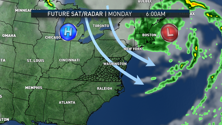
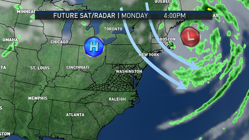
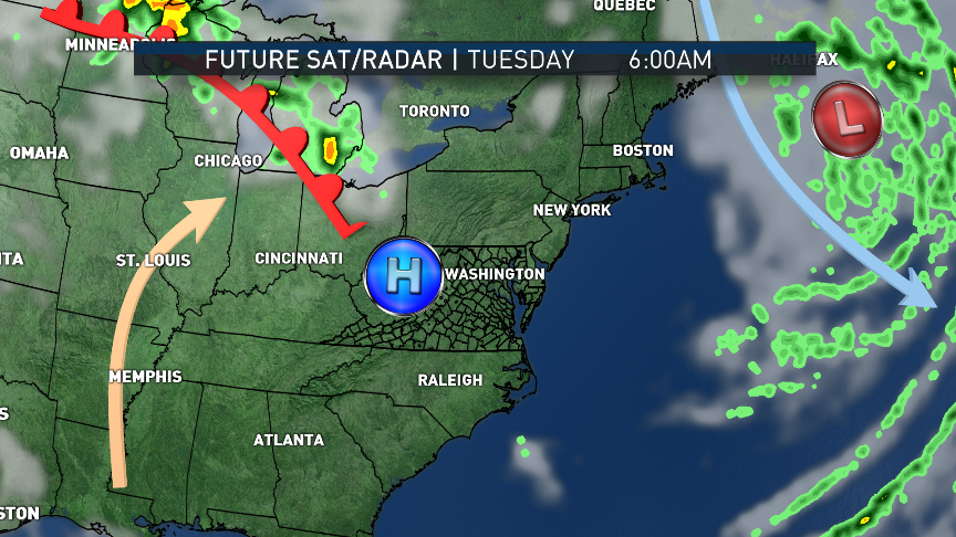
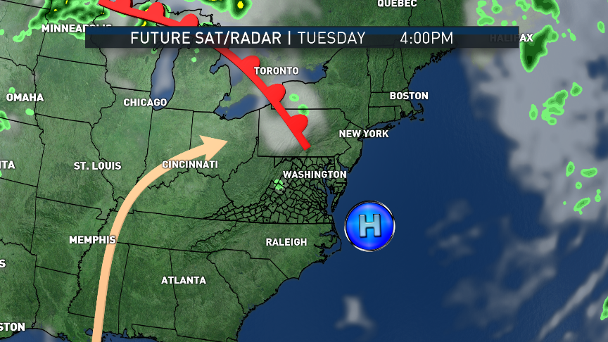
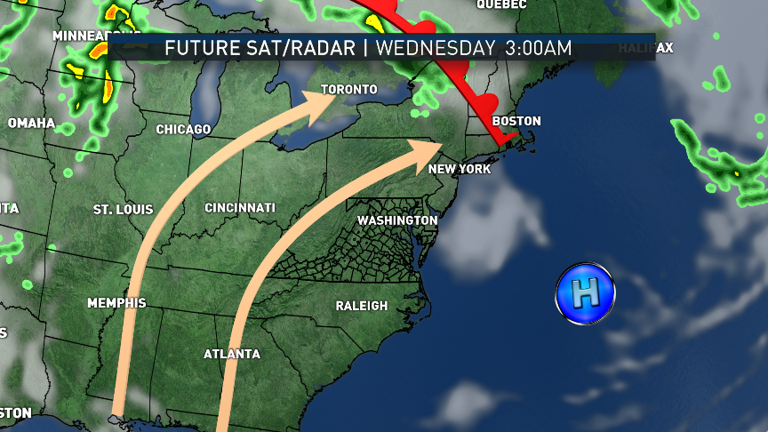
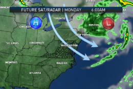
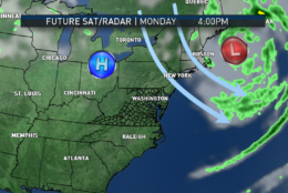
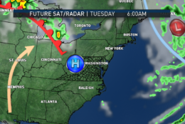
These maps show the future satellite and radar from the RPM computer model from Monday until early Wednesday morning. The northwest flow and strong breezes from Sunday will be replaced by southwesterly winds as the new weather pattern emerges. The center of high pressure will build almost directly over us through Tuesday, then it will head out to sea and become the Bermuda High. A diffused warm front will pass by on Tuesday with a few hours of clouds and maybe a sprinkle in the mountains. Then, the heat will be on!
(Data: The Weather Company. Graphics: Storm Team 4)
Data: The Weather Company. Graphics: Storm Team 4
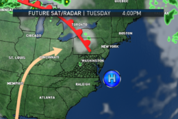
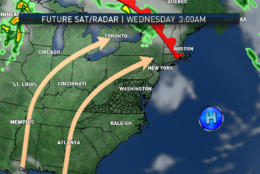
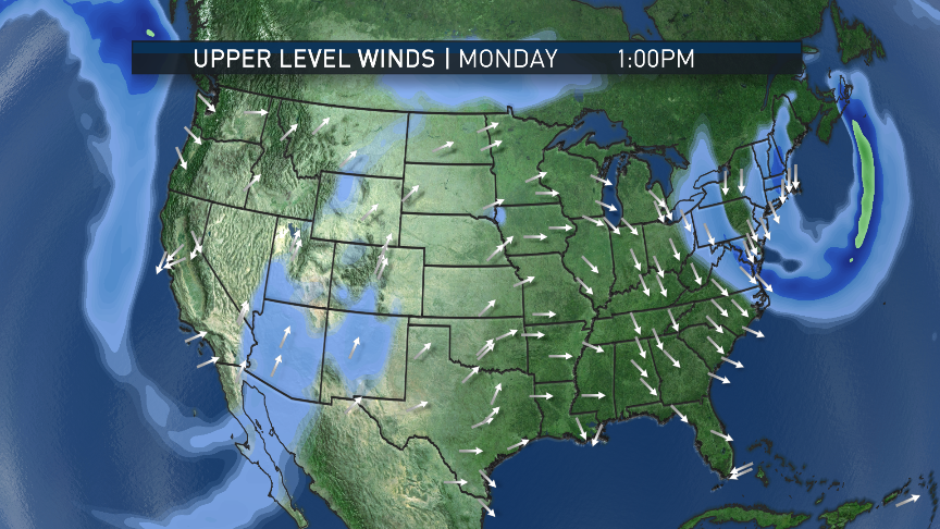
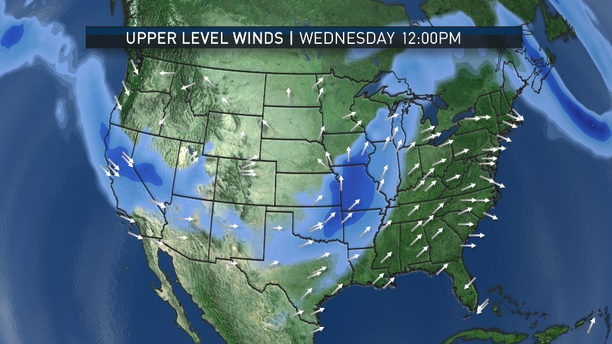
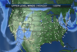
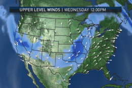
In the upper levels of the atmosphere, in these maps, the GFS computer model depicts the trough in the Northeast departing and a trough setting up in the West with cooler than normal conditions as the colder air flows down from Canada there. The ridge is here in the East; there is no cold air source and our air mass starts well south of here, pumping in heat and even a touch of humidity by Wednesday.
(Data: Environmental Modeling Center, NOAA. Graphics: Storm Team 4)
Data: Environmental Modeling Center, NOAA. Graphics: Storm Team 4
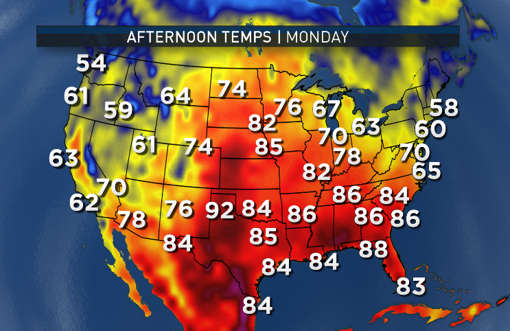
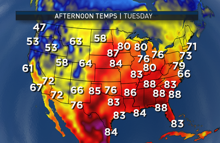
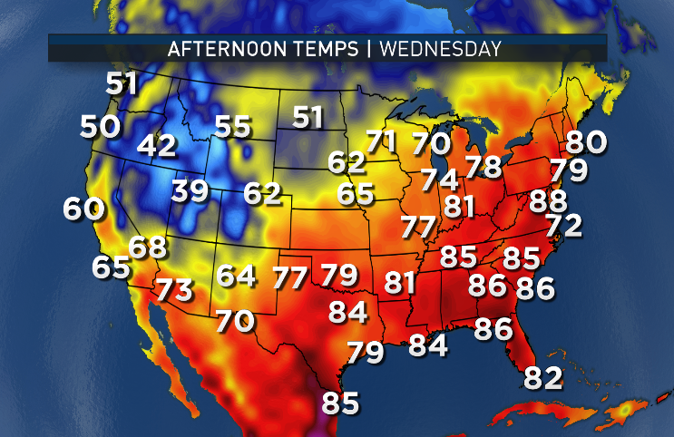
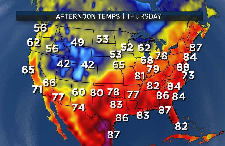
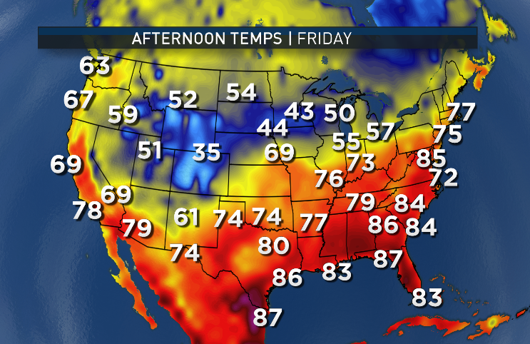
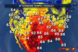
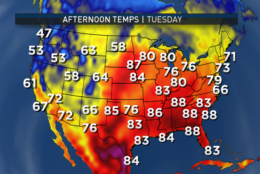
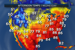
The surface temperatures for the week definitely reflect this pattern as well. Afternoon temperatures in the GFS model show clearly the coldest air out West (even with altitude taken into consideration). The heat is in the East; the model’s numbers for the greater D.C. area are likely just a couple of degrees too low, so adjusting them up as in the actual forecast would place us into the 90s. Toward the end of the week, the heat starts getting knocked down a bit. Extrapolating to the weekend, we will start to see some cooler changes.
(Data: Environmental Modeling Center, NOAA. Graphics: Storm Team 4)
Data: Environmental Modeling Center, NOAA. Graphics: Storm Team 4
Seasonably warm (highs in the mid 70s this time of year)
TUESDAY
Very much like Monday
A few clouds for a few hours in the afternoon
Slightly warmer than Monday
WEDNESDAY
Mostly sunny
Starting to heat up
Close to record highs
Becoming a bit humid during the day
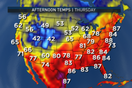
THURSDAY
Mostly sunny, high level clouds and some haze
Very hot and sticky, but below records
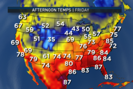
FRIDAY
Building clouds
Hot and humid
Slight chance of late-day thunderstorms
The record highs for Wednesday, Thursday and Friday for the D.C.-area are 92 (1974 and other years), 96 (1877) and 96 (1996). Wednesday’s is a low number comparatively and that record may be in jeopardy. The others probably will stand.
Of course, it is still early for this heat, so it won’t last. The pattern will break down and flatten out, allowing a cold front to sneak down from Canada toward the weekend with a chance for showers and more seasonable temperatures.
Speaking of last week’s rainfall, Reagan National Airport officially picked up 1.86 inches for the storms over the three-day period. That brings us well above average for the month, a bit above average since March 1 and just a bit below average for the year. There is still a deficit from last year to make up, but there have been positive results in the short-term (topsoil, brush, etc.) and the long-term drought effects (waterways). We are expecting good official news concerning the drought to be released this week.
Editor’s Note: The WTOP Workweek Weather Blog is intended as an in-depth yet plain language summary of the business week’s weather potential in the D.C. area along with an explanation of the contingencies and uncertainties that exist at the time of publication. For the latest actual Storm Team 4 forecast, check out the main WTOP Weather Page.