WASHINGTON — As Storm Team4 has been indicating all week, the WTOP listening area could be in for some strong thunderstorms on Thursday.
The second in a series of strong storm systems coming out of the Rockies into the Deep South and moving along the Gulf Coast will be taking a turn up the mountains heading for our area.
Unlike Tuesday’s system, some of the ingredients will be in place to enhance the potential of strong thunderstorms here, some of which could be severe. The upside of all this is that most of the area will get some beneficial rainfall that will mitigate some of the drought conditions.
Storms could smack the D.C. area from 9 a.m. to 3 p.m. Winds in excess of 60 mph and pea-sized hail are possible.
A tornado watch has been issued for some southern counties south of Fredericksburg near Richmond until 1 p.m.
NEW EVENT: TORNADO WATCH ISSUED for yellow highlighted counties until 1pm. Storms poss. in #DMV 9am-3pm. #NBC4DC pic.twitter.com/IrI3CRvl8j
— Chuck Bell (@ChuckBell4) April 6, 2017
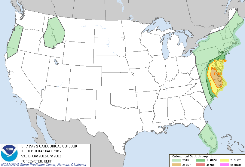
The “Convective Outlook” from the Storm Prediction Center has been focused on our area all week, as well. As of the Wednesday morning update (“Day 2”), most of our area was considered to be at “Slight Risk” for severe thunderstorms. However, the area considered to be in “Enhanced Risk” would include some of the southern counties of the listening area in central Virginia and southern Maryland, all the way down the Northern Neck into Hampton Roads.
What does that all mean?
Most of the area will see thunderstorms, but only a few may reach severe levels. The areas in the Enhanced Risk may see a more serious situation in terms of number of severe thunderstorms and their intensity.
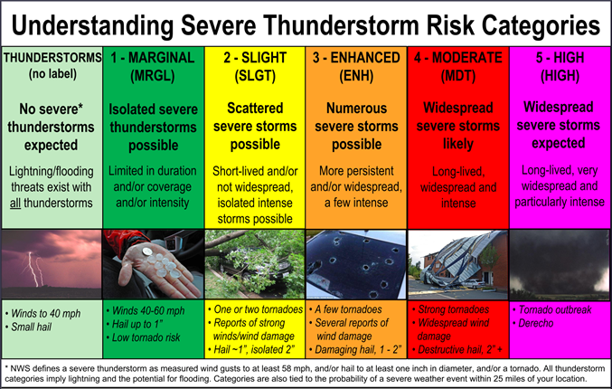
Here is the chart issued by the Storm Prediction Center for these risk categories.
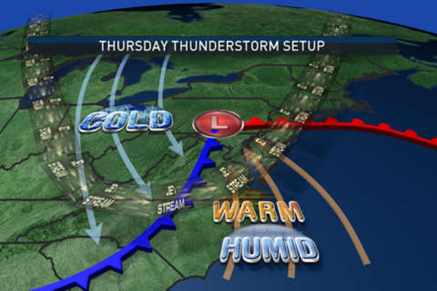
The storms will be the result of a deep area of low pressure deepening in intensity as it moves toward the Great Lakes, and the upper level jet stream winds are “digging” into the Appalachians. At the surface, a warm front will be lifting from the southeast states into the Mid-Atlantic, while unseasonably very cold, dry air will be plunging into the Midwest.
The contrast in conditions on either side of the boundaries will help strengthen the wind speeds just above the surface. The developing thunderstorms will be able to “tap” that momentum and send it toward the surface, resulting in potentially damaging wind gusts. Frequent lightning is a given, but because of how much cold, dry air will be around in the mid-levels, hailstones could be quite large, adding to the damage potential.
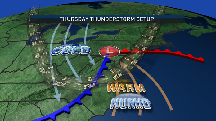
There will likely be two times of day of peak severe activity: in the early morning, the threat will likely be south and east of Washington in the “Enhanced Risk” areas, mostly because the storms will already be ongoing from Wednesday night in the Carolinas and that’s where they would be headed. The Washington area and the northwest suburbs will just have showers and nonsevere thunderstorms.
Then south of the warm front with partial clearing, it will get much warmer and more humid in the early afternoon. That will be just as the atmosphere is cooling significantly aloft and the air is being lifted by the advancing cold front. That means the “Slight Risk” areas will have their great chance for severe thunderstorms from midday through the late afternoon.
Then much cooler air will plunge into our area Thursday night, ushering in a chilly, drizzly Friday.
The factors that could limit the strength of the storms would be a relatively low level of available moisture; in other words, it might not be humid enough for thunderstorm “fuel.” Also, if temperatures don’t rise high enough from enough peeks of sunshine through the clouds, that would also limit severe weather potential. So as always, it’s a fluid situation and Storm Team4 will be monitoring the evolution of the system hour by hour.
South of the warm front, there is the partial clearing and a secondary development of thunderstorms in the middle part of the day. If the greater Washington area is to get the severe weather that’s when it would be.
At any rate, drier air behind the cold front will end all the activity Thursday evening. And yes, that is some significant snow falling in the Ohio Valley in the coldest air. That won’t happen here.
Predominantly easterly directions will be ahead of the warm front early Thursday, then south and southwesterly behind the warm front and we have the warmest part of the day in the late afternoon and evening.
The cool-down ironically may begin with southwesterly winds Thursday evening through Friday morning. Then Friday afternoon temperatures won’t be able to rebound much compared to the morning lows as the steady supply of fresh, cold air comes down the mountains with northwesterly winds.
Finally, how might it all add up?
At least a half inch of rainfall to an inch throughout the area is likely with some locally higher amounts in the strongest thunderstorms. This will definitely help alleviate the drought conditions in the topsoil and brush.