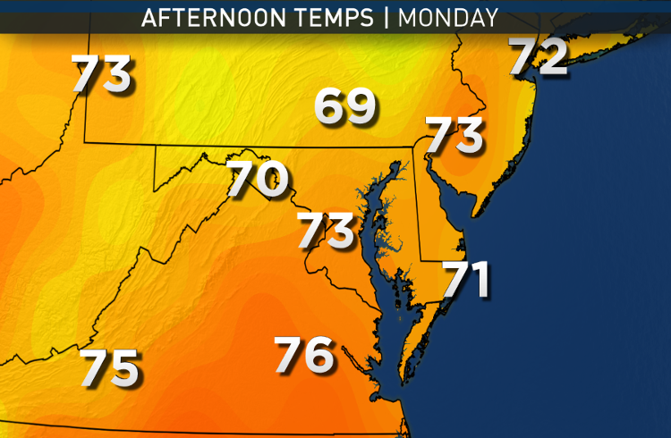
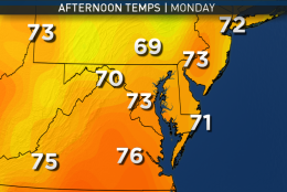
The new workweek will start off with mainly clear skies and some areas of fog, thanks still in part to all the low-level humidity and the moist ground from the “cutoff low” we wrote about last week.
Other than the drizzle on the easterly flow, there is not a lot of chance for rain this week.
(WTOP/Storm Team 4)
WTOP/Storm Team 4
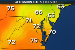
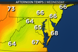
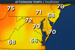
This image progression shows what could happen with our daytime temperatures this week because of the clouds returning after Monday.
(Data: Environmental Modeling Center, NOAA. Graphics: Storm Team 4)
Data: Environmental Modeling Center, NOAA. Graphics: Storm Team 4
(Data: Environmental Modeling Center, NOAA. Graphics: Storm Team 4)
Data: Environmental Modeling Center, NOAA. Graphics: Storm Team 4
There’s a definite downturn toward Wednesday.
(Data: Environmental Modeling Center, NOAA. Graphics: Storm Team 4)
Data: Environmental Modeling Center, NOAA. Graphics: Storm Team 4
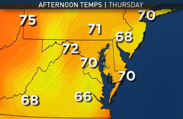
The end of the week may get a boost despite the clouds because of more low-level air coming off the warmer Chesapeake.
(Data: Environmental Modeling Center, NOAA. Graphics: Storm Team 4)
Data: Environmental Modeling Center, NOAA. Graphics: Storm Team 4
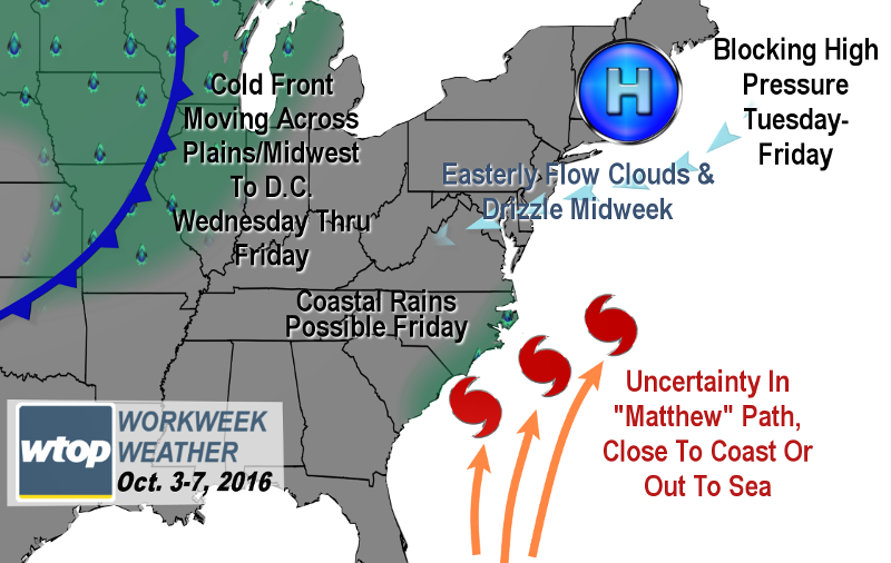
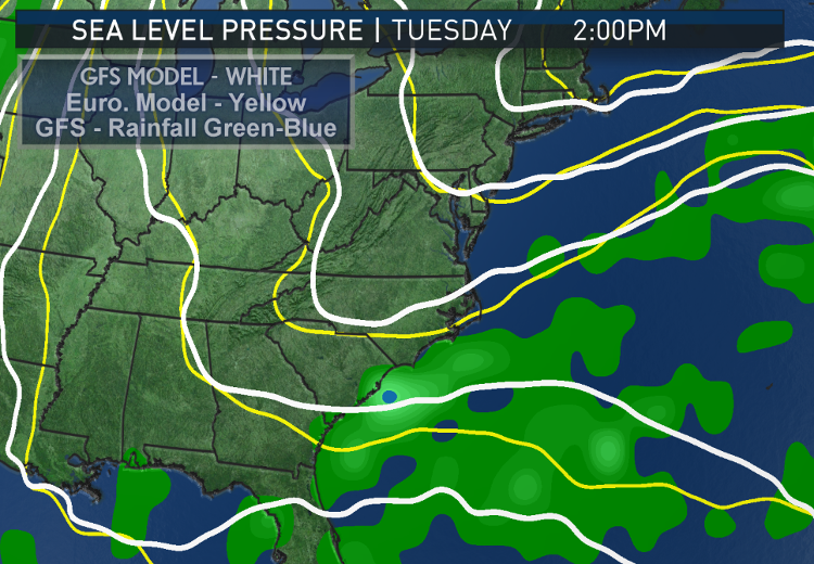
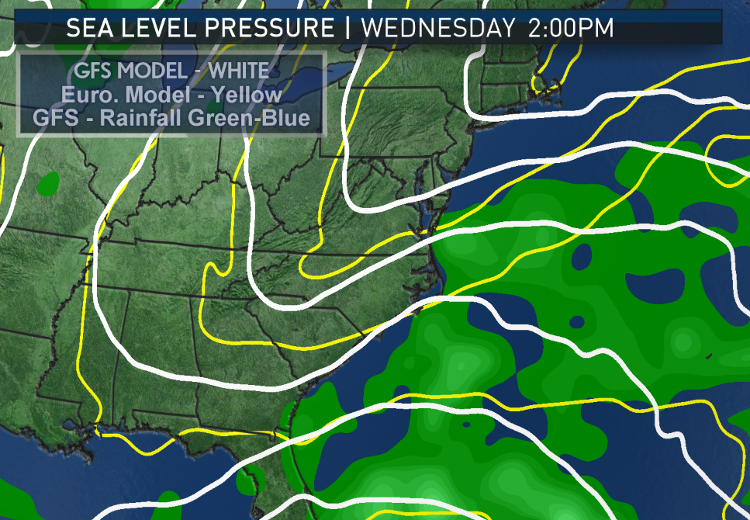
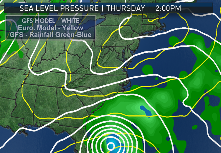
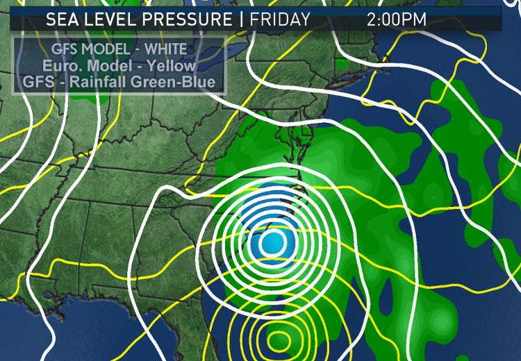
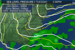
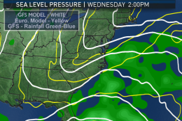
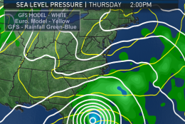
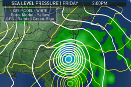
These images are showing how two of the most important computer models to meteorologists are differing on the progression of the Midwest cold front, the blocking high over New England and therefore, the future path of Hurricane Matthew after it moves away from the Bahamas.
The white lines are lines of constant sea-level pressure from the GFS. The yellow lines are from the European Model. The green and blue shaded areas are light rain to heavy rain. Where you see the lines as concentric circles, that approximates the hurricane center. Note, of course, that a hurricane is not just a point, but its effects go far and out from the center. Even if the hurricane never makes landfall, it will still likely bring some rain to the Carolinas coast, winds and riptides.
(Data: Environmental Modeling Center/NOAA and European Center For Medium-Range Weather Forecasting. Graphics: Storm Team 4)
(Storm Team 4)
Storm Team 4
There are huge differences in path, speed and the resulting amount of rainfall that could make it inland. In the farthest west scenario with the American model, the GFS, the Washington area could be on the western fringe of some rainfall and a strong breeze, and that would start on Friday, within the workweek.
(Data: Environmental Modeling Center/NOAA and European Center For Medium-Range Weather Forecasting. Graphics: Storm Team 4)
(Storm Team 4)
Storm Team 4
The worst would be along the coast of the Carolinas and up the Delmarva. The European Model — the ECMWF — on the other hand, stalls Matthew so much that the storm misses being picked up by the cold front and sending it up the coast like the GFS does. In fact, the scenario is much worse for the mid-Atlantic coast in terms of riptides and erosion because it would be so prolonged.
(Data: Environmental Modeling Center/NOAA and European Center For Medium-Range Weather Forecasting. Graphics: Storm Team 4)
(Storm Team 4)
Storm Team 4
But the Washington area would just see a lot of cloud cover out of the European scenario and not rain. Obviously at this point, there are many uncertainties for us for the upcoming weekend.
(Data: Environmental Modeling Center/NOAA and European Center For Medium-Range Weather Forecasting. Graphics: Storm Team 4)
(Storm Team 4)
WASHINGTON — The new workweek will start off with mainly clear skies and some areas of fog, thanks still in part to all the low-level humidity and the moist ground from the “cutoff low” we wrote about last week.
It’s the storm system that brought us all the rain last week and this past weekend. That system has now sheared out and rejoined the jet stream steering winds, and high pressure will build in during the day on Monday, continuing the drying trend. Dew point temperatures will drop into the 50s on Monday, making it feel very comfortable when combined with seasonably warm high temperatures in the low to mid 70s.
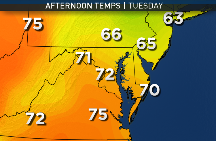
The high pressure system will depart Monday night, sprawling up into New England and becoming a giant block for the eastern seaboard. Storminess will develop in the Rockies and the middle of the country in the form of a cold front. Our winds will be off the ocean on Tuesday, increasing the chance for low clouds and drizzle, especially east of Interstate 95.
Wednesday through Friday will also have an easterly flow, but a bit more variability in wind direction may make for more sunshine than at other times. By Thursday and Friday, we will likely see some very high altitude cirrus clouds on the periphery of Hurricane Matthew. The center of the storm at that time will be near the coast of the Carolinas. If we get any direct effects from the hurricane other than clouds, it wouldn’t occur until Friday at the earliest.
Other than the drizzle on the easterly flow, there is not a lot of chance for rain this week.
Daily weather highlights
MONDAY
• Morning patchy fog, especially in river valleys and near the Chesapeake Bay
• Mostly sunny skies with just fair weather clouds
• Decreasing humidity throughout the day
• Highs close to our averages for this time of year, in the low to mid 70s
TUESDAY
• Morning low clouds and some fog
• East of D.C., some drizzle will be possible
• Temperatures still close to average
WEDNESDAY
• Mostly cloudy, only peeks of sun
• Chance for more drizzle, especially east of D.C.
• Highs below average
THURSDAY & FRIDAY
• A mix of high-level and low-level clouds
• Feeling a little more humid and more uncomfortable
• Highs a little above average, back into the low 70s
• Tracking the hurricane very closely for possible rains and breezes here in D.C. area
• Cold front may bring a few showers on Friday regardless of the hurricane
Editor’s note: The WTOP Workweek Weather Blog is intended as an in-depth yet plain language summary of the business week’s weather potential in the D.C. area along with an explanation of the contingencies and uncertainties that exist at the time of publication. For the latest actual Storm Team 4 Forecast, check out the WTOP Weather Page.