Workweek weather: Cool week ahead without much rain

(WTOP/Storm Team 4)
The summer has its doldrums and sometimes fall can, too. (WTOP/Storm Team 4)
The following two images show the progression of the cold front Monday morning through Monday evening. The data is the Weather Company’s RPM computer model. There is not much to see except some patchy clouds in the morning with the rain falling apart before the front gets here. Behind the front, skies just clear out even more as the atmosphere dries out even more and temperatures keep falling Monday evening into the 30s and 40s. (Data: The Weather Company. Graphics: Storm Team 4)
The following two images show the progression of the cold front Monday morning through Monday evening. The data is the Weather Company’s RPM computer model. (Data: The Weather Company. Graphics: Storm Team 4)
This image shows the progression of the cold front Monday morning through Monday evening. The data is the Weather Company’s RPM computer model. There is not much to see except some patchy clouds in the morning with the rain falling apart before the front gets here. Behind the front, skies just clear out even more as the atmosphere dries out even more and temperatures keep falling Monday evening into the 30s and 40s. (Data: The Weather Company. Graphics: Storm Team 4)
There is not much to see except some patchy clouds in the morning with the rain falling apart before the front gets here. Behind the front, skies just clear out more as the atmosphere dries out even more and temperatures keep falling Monday evening into the 30s and 40s. (Data: The Weather Company. Graphics: Storm Team 4)
The National Weather Service’s GFS computer model is the source for this afternoon temperature data all week. Temperatures will be below average the entire time. The forecast from the actual humans at StormTeam 4 is slightly higher just because of pattern recognition and allow for the dry ground with all the sun of midweek. The reason for the relatively milder air with the clouds and showers on Thursday and Friday is because of the southwesterly winds kicking in with the storm system, the center of which will be heading to our north and west. (Data: Environmental Modeling Center/NOAA. Graphics: Storm Team 4)
The National Weather Service’s GFS computer model is the source for this afternoon temperature data all week. (Data: Environmental Modeling Center/NOAA. Graphics: Storm Team 4)
The National Weather Service’s GFS computer model is the source for this afternoon temperature data all week. Temperatures will be below average the entire time. The forecast from the actual humans at StormTeam 4 is slightly higher just because of pattern recognition and allow for the dry ground with all the sun of midweek. The reason for the relatively milder air with the clouds and showers on Thursday and Friday is because of the southwesterly winds kicking in with the storm system, the center of which will be heading to our north and west. (Data: Environmental Modeling Center/NOAA. Graphics: Storm Team 4)
Temperatures will be below average the entire time.  (Data: Environmental Modeling Center/NOAA. Graphics: Storm Team 4)
The National Weather Service’s GFS computer model is the source for this afternoon temperature data all week. Temperatures will be below average the entire time. The forecast from the actual humans at StormTeam 4 is slightly higher just because of pattern recognition and allow for the dry ground with all the sun of midweek. The reason for the relatively milder air with the clouds and showers on Thursday and Friday is because of the southwesterly winds kicking in with the storm system, the center of which will be heading to our north and west. (Data: Environmental Modeling Center/NOAA. Graphics: Storm Team 4)
(Data: Environmental Modeling Center/NOAA. Graphics: Storm Team 4)
The National Weather Service’s GFS computer model is the source for this afternoon temperature data all week. Temperatures will be below average the entire time. The forecast from the actual humans at StormTeam 4 is slightly higher just because of pattern recognition and allow for the dry ground with all the sun of midweek. The reason for the relatively milder air with the clouds and showers on Thursday and Friday is because of the southwesterly winds kicking in with the storm system, the center of which will be heading to our north and west. (Data: Environmental Modeling Center/NOAA. Graphics: Storm Team 4)
The reason for the relatively milder air with the clouds and showers on Thursday and Friday is because of the southwesterly winds kicking in with the storm system, the center of which will be heading to our north and west. (Data: Environmental Modeling Center/NOAA. Graphics: Storm Team 4)
The National Weather Service’s GFS computer model is the source for this afternoon temperature data all week. Temperatures will be below average the entire time. The forecast from the actual humans at StormTeam 4 is slightly higher just because of pattern recognition and allow for the dry ground with all the sun of midweek. The reason for the relatively milder air with the clouds and showers on Thursday and Friday is because of the southwesterly winds kicking in with the storm system, the center of which will be heading to our north and west. (Data: Environmental Modeling Center/NOAA. Graphics: Storm Team 4)
(Data: Environmental Modeling Center/NOAA. Graphics: Storm Team 4)
(Data and graphics: Environmental Modeling Center/NOAA)
Lastly, again, this looks like a dry weather pattern for us this week. The total from the GFS computer model from Sunday through early Friday morning is only for a few tenths of an inch for us, and that wouldn’t start happening until Thursday. There’s an outside possibility for a little more, but the rule of thumb is to not be too optimistic when in a dry pattern as the dry conditions can be self-perpetuating.  (Data and graphics: Environmental Modeling Center/NOAA)
(1/9)
(WTOP/Storm Team 4)
The following two images show the progression of the cold front Monday morning through Monday evening. The data is the Weather Company’s RPM computer model. There is not much to see except some patchy clouds in the morning with the rain falling apart before the front gets here. Behind the front, skies just clear out even more as the atmosphere dries out even more and temperatures keep falling Monday evening into the 30s and 40s. (Data: The Weather Company. Graphics: Storm Team 4)
This image shows the progression of the cold front Monday morning through Monday evening. The data is the Weather Company’s RPM computer model. There is not much to see except some patchy clouds in the morning with the rain falling apart before the front gets here. Behind the front, skies just clear out even more as the atmosphere dries out even more and temperatures keep falling Monday evening into the 30s and 40s. (Data: The Weather Company. Graphics: Storm Team 4)
The National Weather Service’s GFS computer model is the source for this afternoon temperature data all week. Temperatures will be below average the entire time. The forecast from the actual humans at StormTeam 4 is slightly higher just because of pattern recognition and allow for the dry ground with all the sun of midweek. The reason for the relatively milder air with the clouds and showers on Thursday and Friday is because of the southwesterly winds kicking in with the storm system, the center of which will be heading to our north and west. (Data: Environmental Modeling Center/NOAA. Graphics: Storm Team 4)
(Data and graphics: Environmental Modeling Center/NOAA)

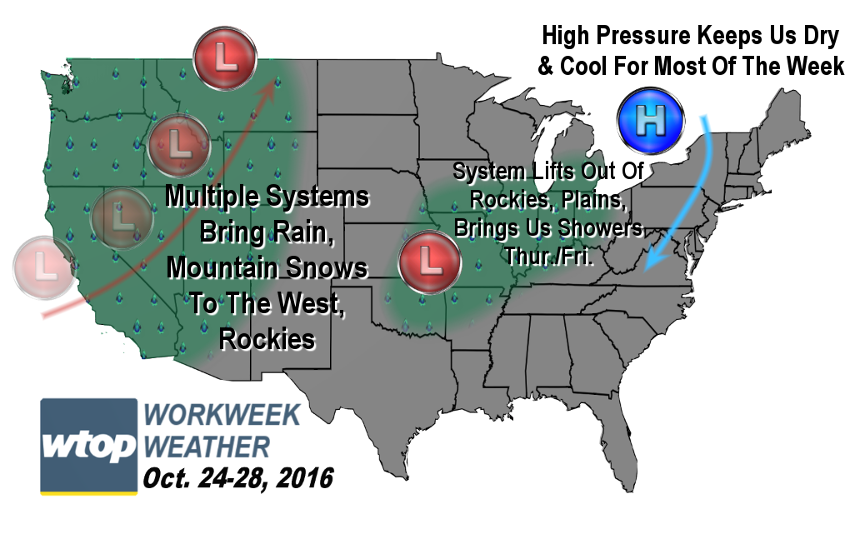
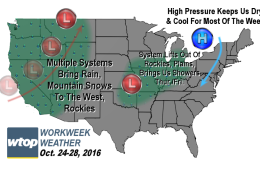
WASHINGTON — The summer has its doldrums and sometimes fall can, too. The WTOP listening area will be in a mostly northwesterly wind flow pattern with the jet stream winds aloft and at the surface, also, meaning few chances for precipitation as a few quick moving disturbances go through the area.

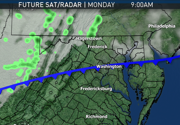
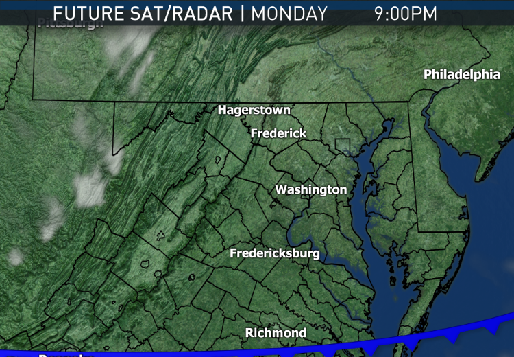
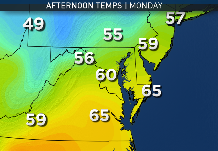
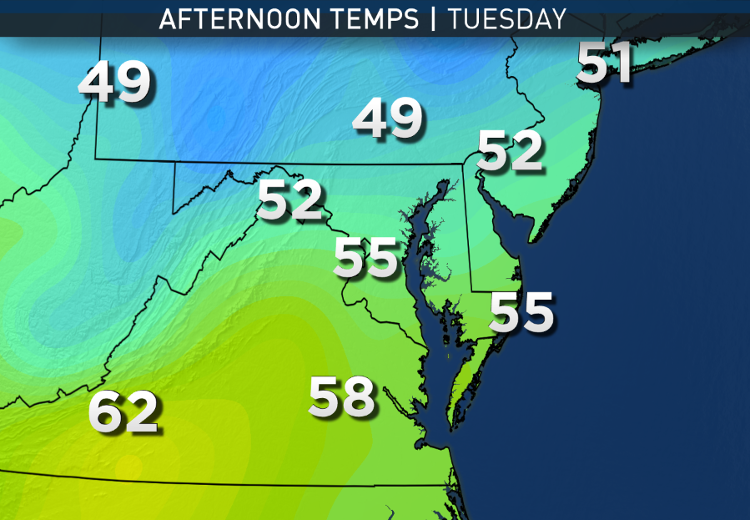
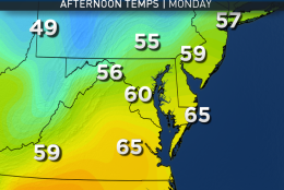
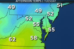
The first will be a weak cold front on Monday, which will pass through without much more than several hours of cloudiness, and possibly a passing shower or sprinkle in northern Maryland and central Pennsylvania. The mountains will make most of the showers dry up and fall apart as the front goes through here. It will, however, keep the wind speeds up, making for a brisk day. The front is “strong” inasmuch as chillier air will move in behind it Monday night, making Tuesday’s temperatures more difficult to recover despite sunshine. After all, sun angle is getting pretty low and with less solar energy reaching the ground, temperatures won’t warm up too quickly.

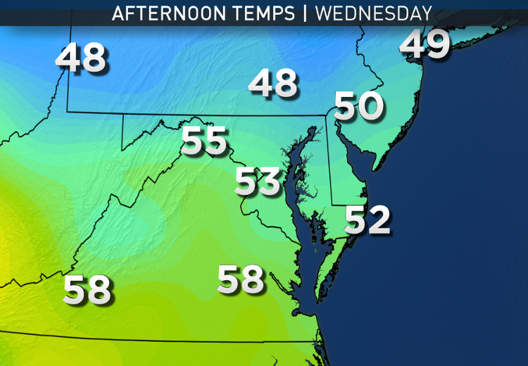
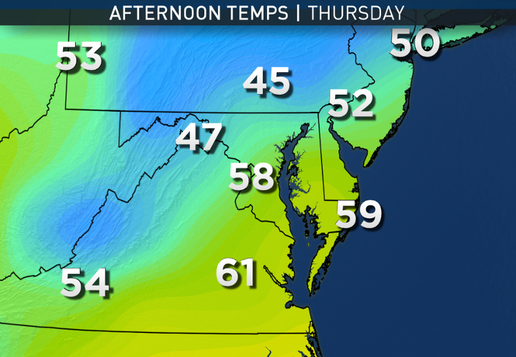
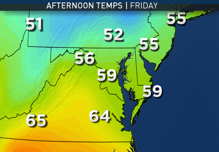
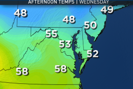
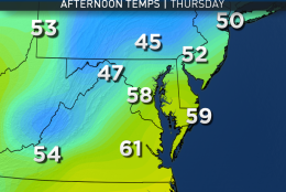
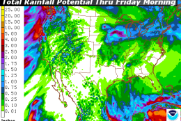
High pressure building over New England will keep the cool flow going all the way through midweek. Toward Thursday and Friday, as the high moves away, we will be tracking a system lifting out of the Rockies up through the Plains. At this early stage in the game, it’s unclear whether showers will arrive with the front Thursday evening or early Friday morning. But experience shows these systems tend to be a little quicker than the computer models suggest, so Storm Team 4 is leaning toward Thursday evening and ending Friday morning, followed by another brisk Friday afternoon. Rainfall amounts do not look like they will be much, regardless.

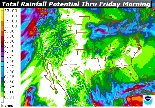
And we could use some rain, which is definitely hard to believe considering all the flooding that Hurricane Matthew caused in the Hampton Roads area of Virginia, and both North and South Carolina. We just didn’t get that much. Even by dry October standards, we are at 0.87 inches, which is 1.64 inches below average.

The total since Sept. 1 is 3.37 inches, which is 2.86 inches below average. And the annual total is 28.30 inches, which is 4.33 inches below average. Of course, we don’t need the rain so much for this year’s agriculture anymore, but dry topsoil, leaves and brush would eventually lead to wildfire dangers. Also, if the dry conditions were to continue through the winter months, we would eventually have groundwater and stream/riverflow problems next spring.

Daily weather highlights

Monday

  • Morning batches of clouds
  • Increasing sunshine through the afternoon
  • Brisk winds picking up during the day, subsiding overnight

Tuesday & Wednesday

  • Abundant sunshine
  • Unseasonably cool
  • Frost potential in the mornings along the mountain valleys and Maryland counties that border Pennsylvania

Thursday

  • Increasing clouds; possibly cloudy already by sunrise
  • Unseasonably cool all day
  • Showers arriving in the evening if not earlier in the afternoon
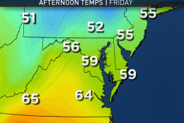
Friday

  • Showers ending by midday
  • Windy, brisk and cool


EDITOR’S NOTE: The WTOP Workweek Weather Blog is intended as an in-depth yet plain language summary of the business week’s weather potential in the D.C. area along with an explanation of the contingencies and uncertainties that exist at the time of publication. For the latest actual Storm Team 4 forecast, check out WTOP’S weather page.

Federal News Network Logo
Log in to your WTOP account for notifications and alerts customized for you.

Sign up