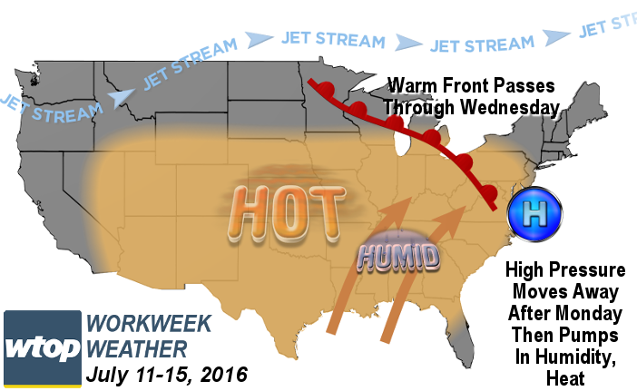
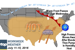
WASHINGTON — The new workweek will be very similar to last week’s and we’ll have all the same players — high pressure, warm front, southwesterly winds and more — but there are a few borderline situations this time around which will determine whether another official heat wave is headed our way. But the humidity this week has the potential to be even higher, so any way you slice it, it looks like an uncomfortable stretch of weather after Monday.
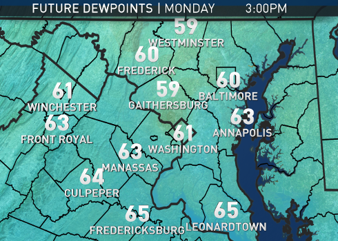
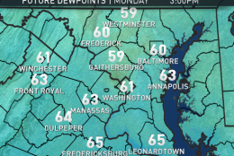
Monday will be dominated by another of our series of dry, Canadian high pressure domes that we’ve had since the end of May. We will have dry, northwesterly winds keeping the humidity low, or at least low enough that a lot of people won’t notice. A dew point in the upper 50s or low 60s will feel borderline comfortable/sticky. Near full sunshine will warm temperatures up to the upper 80s, but that’s perfectly average for this time of year. Then things begin to change as the high pulls away and heads out to sea. It becomes the “Heat Pump” again, and the jet stream steering winds will be lifting back north into Canada, sending a warm front our way by midweek.
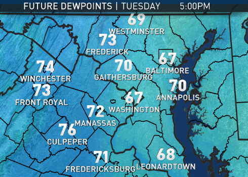
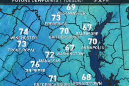
Southeasterly winds Monday night into Tuesday will already be transporting in moisture from the ocean and the bay. Dew points will climb back into the upper 60s if not low 70s. That will start to feel much more uncomfortable to most. However, building clouds and a few isolated thunderstorms forming during the day will block more sunshine, so temperatures will likely stay in the 80s.
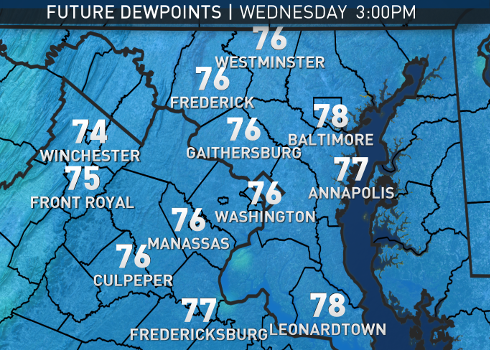
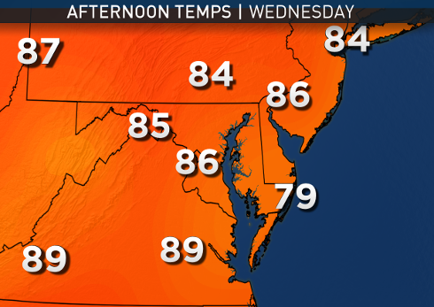
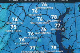
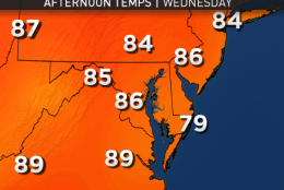
The pattern will continue into Wednesday as the warm front starts moving through. Dew points will likely be in the low 70s everywhere then, making it feel very muggy. The clouds and scattered thunderstorms again could keep us below 90. Behind the warm front, temperatures look like they will easily get into the low 90s, so Wednesday is the wild card for an official heat wave during the workweek.
A cold front will then pass through on Friday with some storms, so when the Nationals start up again after the All-Star break that evening, we will have to keep an eye to the sky.
MONDAY:
• Comfortable morning
• Warm afternoon
• Low humidity; doesn’t make it feel much warmer
• Near full sunshine
TUESDAY:
• Increasing clouds, increasing humidity
• Starts to feel muggy to most people by the end of the day
• Risk of an isolated late day thunderstorm or two
WEDNESDAY:
• Even more humid, starting to feel almost sultry
• More of a risk of late day thunderstorms, but still scattered, i.e. we won’t all get them
• Any extended peeks of sun through clouds could help us reach 90
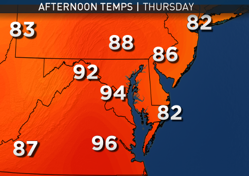
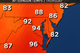
THURSDAY:
• The three h’s are back: hazy, hot and (very) humid
• Heat index close to 100
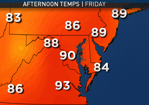
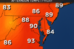
FRIDAY:
• Hazy, hot and humid
• Heat index close to 100
• Late day thunderstorms
The following maps show the likely progression of the comfort factor during the first half of the week. In these particular maps, don’t think “cool” for the blue colors. Think water vapor (moisture in the air). The higher the dew point, the more moisture in the air, and the more uncomfortable it feels. The computer model providing the values is the Weather Company’s RPM.
NOTE: The WTOP Workweek Weather Blog is intended as an in-depth yet plain language summary of the business week’s weather potential in the D.C. area along with an explanation of the contingencies and uncertainties that exist at the time of publication. For the latest actual Storm Team 4 forecast, check out the main WTOP Weather Page.


