WASHINGTON — The high temperature at Reagan National Airport was 90 degrees exactly Thursday. So with the easy presumption that the next two days will have 90 degrees or above for high temperatures, the area has already started its latest heat wave. However, this time around it will be quite hot, likely the hottest weather the region has had in years.
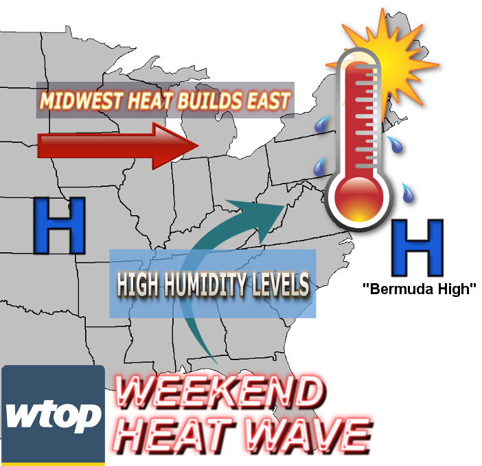
The heat has been building all week in the nation’s midsection underneath a very large ridge of high pressure, an area of sinking, compressing air, aided by the strong July sun angle. An area of high pressure which came down from Canada in the middle of the week — the one that brought the comfortable weather — has now taken up position off the coast, becoming the latest “Bermuda High.” Many are familiar with this term, as these systems bring the usual persistent stretches of hazy, hot and humid weather. In this case, it’s largely responsible for the change in humidity, as it would be hot anyway because of the air mass spreading east from the Midwest.
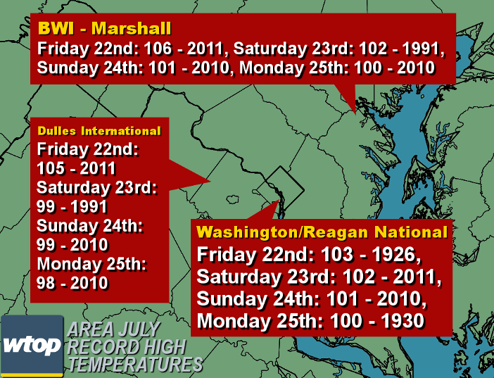
All the conditions will contribute to temperatures being close to 100, especially Saturday and Sunday. It has not hit 100 degrees at Reagan National since July 26, 2012, when the high was exactly 100. But it will definitely be in the neighborhood. All the area major airports will be flirting with their record highs, especially Dulles, owing to its comparatively short length of a records base, in terms of years of existence. (Note also that D.C.’s records predate the existence of Reagan National.)
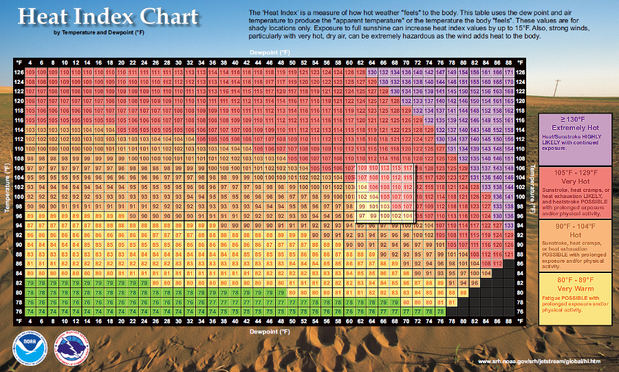
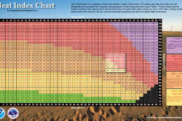
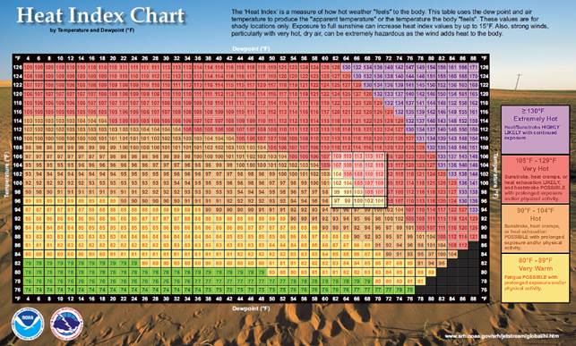
But what’s somewhat unusual about this heat wave will be how humid it will be at the same time. That will mean some unhealthy if not dangerous heat index values. The heat index is a temperature “adjustment” relative to the human body’s ability to cool itself to maintain internal temperature; it’s the same concept as the wind chill in the colder months. The higher the amount of moisture in the air (reflected by a type of temperature called the dew point), the less sweat evaporates off the skin, evaporation which would have taken excess body heat with it.
In this region, typically when dew points are in the 50s, it feels great in the summer. When they get into the 60s, it starts feeling sticky and muggy. When they get into the 70s, it feels tropical. This weekend the dew points will sometimes be in the low 70s, so that will have a big impact on making the heat feel oppressive.
The following is a comprehensive chart of the heat index as a function of temperature and dew point. The range of probable heat index values over the weekend is highlighted. The National Weather Service will have to likely issue at least “heat advisories.” There is a slight chance there will be a relatively rare “excessive heat warning.” The former is intended for persons who are especially susceptible to the heat and to stress “common sense” safety rules for everyone else. The latter is intended to stress the danger of the heat to everyone.
As hot and humid as it will be over the weekend, there won’t be much of a chance for showers and thunderstorms to provide relief because the upper atmosphere will have a “cap” of heat and humidity, and the air will generally be sinking from the high pressure. Thunderstorms will have to develop on their own by breaking that cap. So any storms will be mostly isolated and short-lived and may be mostly confined to the differing terrains of the mountains or near the relatively cooler air near the bay shore. The chance for storms will increase with a weak cold front coming down from Pennsylvania, lifting the atmosphere late Sunday or Monday. That front will temper the heat wave a bit and get temperatures back down into the lower 90s for most of next week, removing the worst of the conditions. Think of it as going from dangerously hot to “regular” D.C. summertime hot.
An excellent comprehensive source for heat related information can be found online from the National Weather Service — it even has explanations for various heat advisories. And for the latest Storm Team 4 forecast, visit WTOP’s Weather Page.