Editor’s Note: This article is intended as an in-depth but plain language discussion for the Washington area’s weather factors, ingredients, and the uncertainties involved. For the latest Storm Team 4 Forecast details, check out the main WTOP Weather Page.
WASHINGTON — The winter weather pattern that waited until spring to really start is evolving. This will mean some immediate changes: The rest of the new workweek looks much more like mid-April. Temperatures will generally be near or just below average, but at least that does not mean any arctic intrusions with chances of freeze or frost.
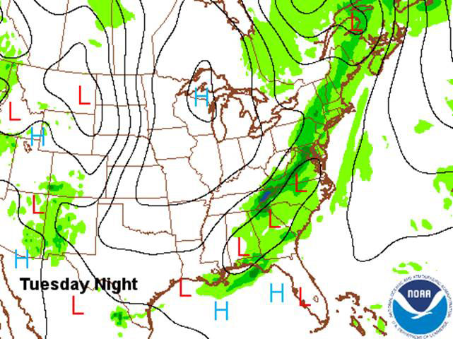
The first immediate change: no freezing low temperatures for Monday morning. High pressure at the surface will help build a weak ridge in the jet stream over the East Coast, allowing a slow moving storm system to approach and hang around for a few days and tapping some moisture from the Gulf of Mexico. This will mean some rain chances, which are needed. Even though the region has seen some storms lately (even the ones with snow melt), they haven’t added up a whole lot because the systems were too quick or the showers were very scattered. At Ronald Reagan Washington National Airport, the deficit of rainfall and snow melt since March 1 is almost 2.50 inches, almost 1.25 inches for the year.
How much rain the area gets depends on the speed of this next system. It will first send a warm front through on Monday — and you’ll notice the change in temperature, even though highs will technically just be seasonable — followed by a cold front Monday night. That front will become almost stationary on Tuesday. Monday’s precipitation looks like it will just be generally light and showery, so not all of the area will get it and not a lot of it will soak in. For Tuesday, however, the indications are strong that a wave of low pressure will enhance the energy along the front, bringing true umbrella weather with almost an inch of rainfall possible. There’s a possibility the front will linger into Wednesday, but the thinking at StormTeam 4 is that the front will move right along, “pushed” by another high pressure system from Canada.
These four images show the output from the American “GFS” model for rainfall chances Monday through Tuesday night and early Wednesday morning. Lighter green colors are for light amounts, darker green and blues are for higher amounts.
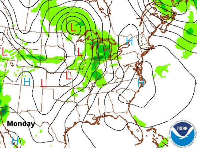
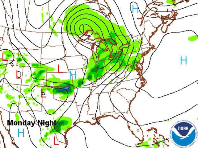
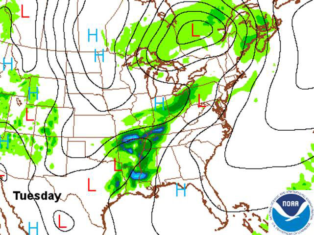
One of the unfortunate aspects of large-scale pattern changes like this is that every little detail matters in the atmosphere, and sometimes the data can miss the details or the equations in the computer models can’t process every little subtlety. There is a wide range in computer forecasts for rainfall amounts and temperature ranges this week. It is possible there will be a little more rain Monday through Wednesday if the front slows down. If the front is a little faster, look for less rain. But recognizing this pattern as typical for this time of year, confidence is high for some April showers this week, and Tuesday is the best chance for them. Also, with the arctic cut off from the lower 48 states, as mentioned before, we won’t have any freezes this week.
Workweek highlights
Monday:
- High temperatures near averages in mid 60s
- Will feel a whole lot warmer by comparison to the weekend
- Just showers: won’t be raining everywhere and not all the time
- Nats game may have some showers but still playable
Tuesday:
- Best chance for rain all week
- Not just showers, raining in most areas most of the day
- With most rain likely in evening, Nats game may be affected
- Depending on position of frontal boundary, could be wide range in temperatures from northern Maryland to central Virginia and southern Maryland with the District in-between
Wednesday:
- Depending on ultimate speed of the front, showers could linger into the morning, especially south of D.C., while everyone else is still cloudy
- If front ends up faster, skies will be clearing already in the morning and more sunshine would mean higher temperatures
- Looks like a breezy day regardless
Thursday and Friday:
- For now it looks like high pressure will keep us dry and mostly sunny with more seasonable temperatures
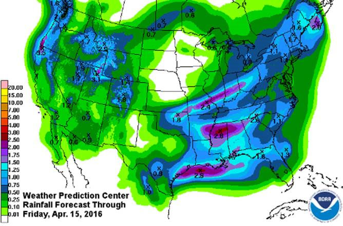
This graphic from the Weather Prediction Center shows the potential for several tenths to an inch of rainfall for the workweek. For us, it would be mostly Monday and Tuesday. The larger amounts in the South are from heavier thunderstorms.
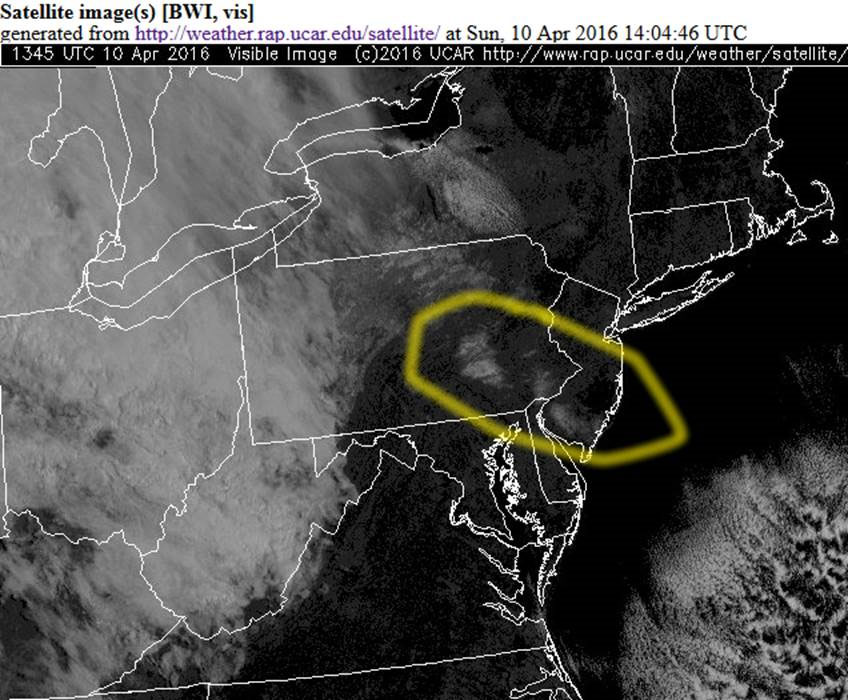
Lastly, take a look at a visible satellite picture from early Sunday morning. The highlighted areas show what was left of the snowfall from that vigorous, cold system from Saturday (a lot of ours had melted already and you don’t see it anymore). The bright areas to the west are the clouds which were advancing along the warm front. This picture demonstrates just how small in terms of square mileage the thermodynamic forces that determine precipitation type and amounts can be, on the same scale as individual counties. But what makes this snow really unusual is that it wasn’t just in the higher elevations, where snowflakes have less time to melt. We got several inches in many spots in southern Maryland, and they got several in south Jersey, much closer to sea level! Definitely an odd occurrence for April.