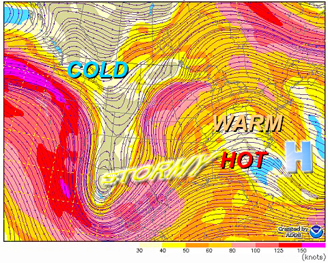
WASHINGTON — The strongly amplified weather pattern dominating North America right now is pumping unusually warm, but dry weather here along the Eastern Seaboard, and a pattern like this is usually slow to break down.
As a result, for a couple of days at least, some record highs will be challenged or broken. All the cold and stormy weather is in the Rockies, the southern Plains and the lower Mississippi River Valley. It’s as if a “Bermuda High” were affecting us like the ones that cause heat waves in the middle of summer.
Here’s a summary of the record highs and years they were set at the big three area cities/airports.
Washington, D.C. (Reagan-National)
Wed., March 9: 80 – 1964
Thu., March 10: 78 – 2006
Fri., March 11: 78 – 1967
Washington, D.C. (Dulles)
Wed., March 9: 79 – 2000
Thu., March 10: 78 – 2006
Fri., March 11: 77 – 1990
Baltimore, Md. (BWI – Thurgood Marshall)
Wed., March 9: 79 – 1964
Thu., March 10: 77 – 2006 (and previous years)
Fri., March 11: 75 – 1967
In addition to these record highs, we could be dealing with new record lows, too; that is, record warm low temperatures (as opposed to the usual record cold low temperatures we talk about). Those record “high minimums”) are as follows.
Washington, D.C. (Reagan-National)
Wed., March 9: 52 – 2000
Thu., March 10: 56 – 2006
Fri., March 11: 53 – 1925
Washington, D.C. (Dulles)
Wed., March 9: 46 – 1964
Thu., March 10: 56 – 2006
Fri., March 11: 49 – 1967
Baltimore, Md. (BWI – Thurgood Marshall)
Wed., March 9th: 56 – 1921
Thu. March 10th: 56 – 2006
Fri. March 11th: 53 – 1955
Data source: National Weather Service, Sterling, Va.


