Listen live to WTOP for the latest traffic and weather on the 8s.
Keep that snow shovel handy. Forecasters are predicting another 1 to 3 inches of snow for the D.C. region Friday to end a workweek that began with the most significant snowfall the area has seen in two years.
The snow is expected to start coming down early in the morning, according to 7News First Alert Chief Meteorologist Veronica Johnson.
- Listen to WTOP online and on the radio at 103.5 FM or 107.7 FM.
- Current traffic conditions
- Weather forecast
- Closings and Delays
- Sign up for WTOP alerts
“Low snowfall amounts, high impacts to area roads, that’s going to be all day Friday, even going in to Saturday morning with lower temperatures expected,” Johnson said. “By 5 a.m., we’ll have snow falling around the area the way it’s looking now and continuing until 8 p.m. That’s when the snow will end.”
To prepare for the incoming snow, the National Weather Service issued a winter weather advisory, which will be in effect from 4 a.m. to 7 p.m. in the WTOP listening area.
Johnson said the snow will start tapering, though, around 2 p.m.
The NWS is predicting less than 1 inch of snow for D.C., with suburbs to the north and west getting more accumulation.
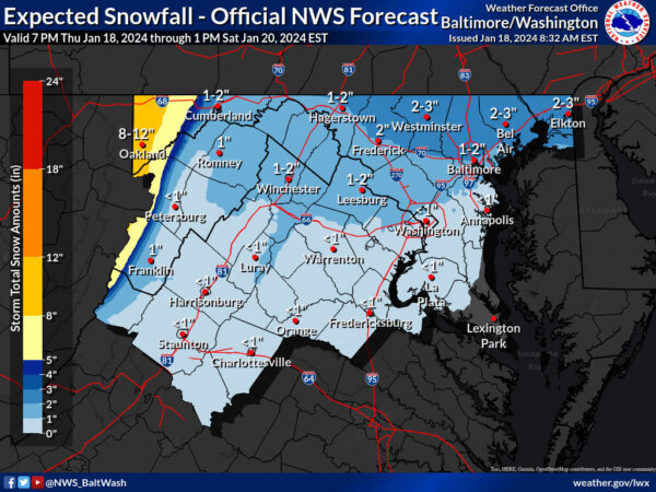
D.C. has a 37% chance to see more than 2 inches of snow, according to the NWS. Frederick, Maryland, meanwhile, has a 49% chance of more than 2 inches and a 15% chance of more than 4 inches. In Oakland, Maryland, the NWS predicts there’s a 52% chance of more than 8 inches.
The snow will pile on top of remnants of Monday’s snowstorm, which brought 2-6 inches of accumulation to the area. The District got around 4 inches Monday, but some parts of Fairfax County, Virginia, and Montgomery County, Maryland, topped 5 inches.
A notable amount of that snow has stuck around due to cold temperatures that moved in after the snowfall, and Friday’s system will be no different.
“Blustery conditions all weekend long with highs in the mid 20s Saturday, lower 30s for Sunday,” Johnson said. “Wind chill temperatures Saturday — grab those gloves and something warm again — single digits all day long.”
The cold temps Saturday could create another “hard freeze,” and bring more difficult conditions for D.C. area drivers to end the week.
Closings and Delays
A series of D.C. area school systems — including Fairfax and Arlington counties in Virginia and Montgomery and Howard counties in Maryland — announced closings or delayed openings for Friday due to expected weather conditions. See the full list here.
Preparing for more snow
Ahead of Friday’s flurries, D.C. Mayor Muriel Bowser extended the city’s Cold Weather Emergency through Sunday and announced the District Snow Team would deploy Thursday night.
Starting at midnight, D.C. crews will apply salt on all snow emergency routes in the District. Residential and side streets are already pretreated due to the amount of brine and salt spread during Monday’s snowfall, the mayor’s office said in a news release.
The Virginia Department of Transportation also said its pretreating roads and will have crews at the ready once the snow begins to fall Friday. Since below-freezing temperatures will stick around for much of the weekend, VDOT said many areas are likely to experience refreeze.
With crews making preparations ahead of the storm, WTOP Traffic Reporter Dave Dildine said it shouldn’t be a worst-case scenario for your Friday commute.
“There will be mishaps and while snow will fall on the roads during the daytime, when traffic is heavier, the sun’s radiation through the clouds and rigorous road treatment should prevent any widespread gridlock.”
Full forecast
THURSDAY EVENING: Becoming cloudy
Temps: 28-35
Winds: South 5-10 mph
Temperatures drop below freezing in most neighborhoods by 6 p.m.
OVERNIGHT: Cloudy, snow showers developing
Lows: 26-32
Winds: Northeast 5 mph
Snow showers will develop from west to east beginning around 2 a.m. with snow inside the Beltway by 4 a.m. Temperatures will be around freezing, so the snow will stick to the ground and any untreated road surfaces. Plan for delays and closures Friday with light snow impacting the morning commute.
FRIDAY: WINTER ALERT
Snow likely
Highs: 31-36
Winds: Northeast 5-10 mph
Plan for delays and closures with light snow during the morning commute. Light snow will continue through the mid afternoon with snow tapering off between 3-4 p.m. Accumulations will be around 1 inch in D.C. Areas north and west of the District could see 2-3 inches of snow by day’s end.
SATURDAY: COLD ALERT
Highs: 22-29
Winds: Northwest 15-20, gusts 30 mph
Cold and blustery weather will kick off the weekend. Wind chills will start off in the single digits and will only climb into the low teens by the afternoon. Wind chills will fall back into the single digits for your nighttime plans, so dress warmly if you will be outdoors.
LOOKING AHEAD:
A pattern change is expected next week with high temperatures Tuesday back into the upper 40s with highs in the upper 50s by the end of the week. Tracking rain next week with chances on Wednesday, Thursday and early Friday.
Current radar
Get breaking news and daily headlines delivered to your email inbox by signing up here.
© 2024 WTOP. All Rights Reserved. This website is not intended for users located within the European Economic Area.