In the midst of a cold snap, a weather pattern transition this week will bring rapid changes to the Washington area that will be a delight to holiday travelers.
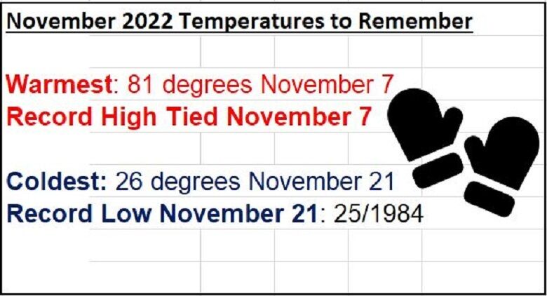
Monday marks the ninth consecutive day with colder than average temperatures in Washington, but it’s been a roller-coaster ride this month. Believe it or not, Reagan National Airport tied a record high on Nov. 7 with a high of 81 degrees.
- More Weather News
- More Local News
- Listen to WTOP online and on the radio at 103.5 FM or 107.7 FM.
- Sign up for WTOP alerts
Another alarming statistic is that while temperatures have been below average the past nine days, the average November temperature is still above-average — 55.9 degrees compared to the average of 51.7 degrees. Not to be outdone, Monday morning’s low temperature at Reagan National Airport of 26 degrees was just one degree off the record low for Nov. 21 set in 1984.
Since Nov. 13, Canadian high pressure has brought the stretch of cold weather. This pattern can be attributed to a prolific high pressure ridge that has been established in Alaska that drained the cold air south right into the Mid-Atlantic. Typically, this Alaska Ridge regime brings the coldest weather of the season to the Washington area.
The bitter cold air pushing across the warm Great Lakes was responsible for the prolific lake-effect snow in Western New York, with Orchard Park topping the list at 80 inches. To put this in perspective, the snowiest winter ever in Washington was 2009-2010 with 56.1 inches.
The cold snap is breaking down this week with the jet stream lifting north of Washington. The area will see a progressive warming pattern each day through Thanksgiving Day. The average high temperature on Thanksgiving Day is 54 degrees and the mercury will reach a few degrees warmer than that.
Along with the pattern change will come a quiet stretch of holiday travel up and down the East Coast until Friday. A moisture-logged front promises rain on Friday followed by breezy conditions this weekend.


