If it seems like the remnants of Hurricane Ian are haunting the Eastern U.S., you’re not wrong. The deadly storm now ranks second among hurricanes in terms of area with more than 10 inches of rain in a day.
Ian produced more than 10 inches of rain over at least 5,685 square miles of real estate on Sept. 29, when it moved off Florida’s Atlantic coast, according to the National Weather Service Weather Prediction Center.
In order to qualify as a “prolific tropical rainfall day,” a hurricane must produce 10 inches of rain in a 24-hour period. Hurricane Harvey tops the list, with more than 10 inches of rain over 16,241 miles in Texas between a 24-hour period from Aug. 27 to Aug. 28, 2017.
- Listen to WTOP online and on the radio at 103.5 FM or 107.7 FM.
- Current traffic conditions
- Weather forecast
- Closings and Delays
- Sign up for WTOP email alerts
- Get custom alerts with the WTOP app for Apple and Android phones
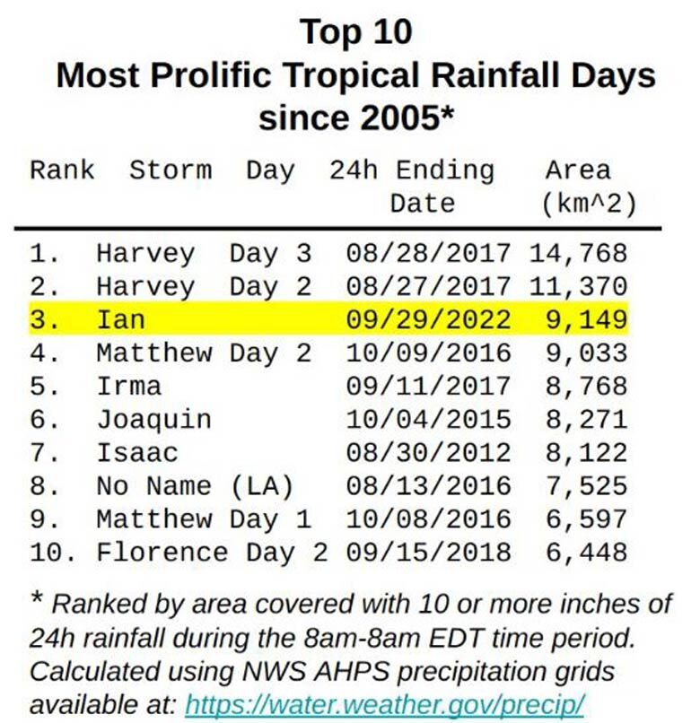
Other hurricanes that ranked in the top 10 for unleashing more than 10 inches of rain within a 24-hour period include Matthew on Oct. 9, 2016; Irma on Sept. 11, 2017; Joaquin on Oct. 4, 2015, and Isaac on Aug. 30, 2012.
The common denominator to all these storms was their slow track along the Gulf/Atlantic coast, which helped produce a widespread deluge. Texas, Louisiana, Florida and the Carolinas were hit hardest by these prolific rain-producing hurricanes.
It’s also interesting to note that the 10 most prolific tropical rainfall days were all between mid-August and October, highlighting the significance of tropical systems that develop during the peak of the season.
While storm surge and high winds create their own trouble, heavy rain triggers damage and is responsible for the second leading cause of deaths in tropical systems.
Of these hurricanes, only Ian and Matthew produced rain in the D.C. region.
The District tallied 0.34 inches of rain when Matthew zipped up the southeast Atlantic coast in early October 2016 and then slowed after approaching the Carolina coast. The core of the heaviest downpours stayed southeast of the District, in Virginia and eastern North Carolina.
Ian’s remnant low is now lumbering off the mid-Atlantic coast and remains an eyesore through Wednesday. Reagan National Airport has measured 1.04 inches so far, with another inch to an inch and a half expected before the rain finally moves away on Wednesday afternoon.