As Hurricane Ian drives torrential downpours through Florida during the midweek, the storm is an important reminder of how insurmountable flooding can unfold in tropical cyclones.
While rainfall amounts will exceed a foot in central and northern Florida as Ian slowly trudges through the state, past history reveals unfathomable rain amounts occur in tropical systems.
The current record rainfall from a tropical system in Florida is Hurricane Easy in September 1950, which produced 45.2 inches in Yankeetown.
Unlike Ian, which will track through central and northern Florida, Easy went north, parallel to Florida’s Gulf Coast, slowed down, looped off the coast and then made landfall north of Tampa.
Easy then finally slid through the northern half of the Sunshine State. The highest rain total, in Yankeetown, occurred where the storm slowed and looped before pushing onshore. Easy proved that stalling or looping tracks often unleash insurmountable rainfall amounts.
If Ian slows during any of its course through Florida, similar amounts could be realized. It’s expected that roads will be closed for several days until the water recedes.
So, what’s the historical track of hurricanes to produces monumental rainfall in the D.C. region? In mid- to late August 1969, Hurricane Camille made landfall along the central Gulf Coast and then pushed into the Tennessee Valley before pushing due east into the Mid-Atlantic along a stalled front.
This boundary worked in tandem with Camille to produce 27 inches of rain in west Nelson County, Virginia. Just for reference, this amount is half of south-central Virginia’s annual rainfall amount of 42.82 inches.
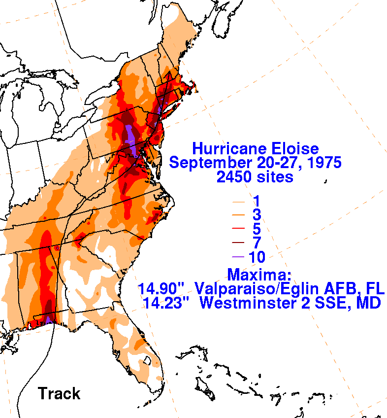
Maryland’s highest rainfall total from a tropical system was unleashed when Hurricane Eloise pushed from the east-central Gulf Coast into the Appalachians and then jumped over the mountains and pushed north along Interstate 95 in Maryland in late September 1975 as a cold front approached. Westminster, Maryland, was soaked with 14.23 inches of rain.
Not to be outdone, Hurricane Sandy in October 2012 made a left hook from the Atlantic and made landfall in southern New Jersey. Delaware’s highest tropical cyclone rainfall total occurred with this storm; 10.98 inches soaked the northern half of the state.
Sandy combined with an upper trough approaching from the Great Lakes to help enhance rainfall in the Mid-Atlantic.
The common denominator with these insurmountable rainfall totals locally was a combination of the moisture from the tropical system and interaction with a front or another approaching mid-latitude weather system. Additionally, these extreme rainfall totals tend to occur during the peak of the hurricane season in August and September.
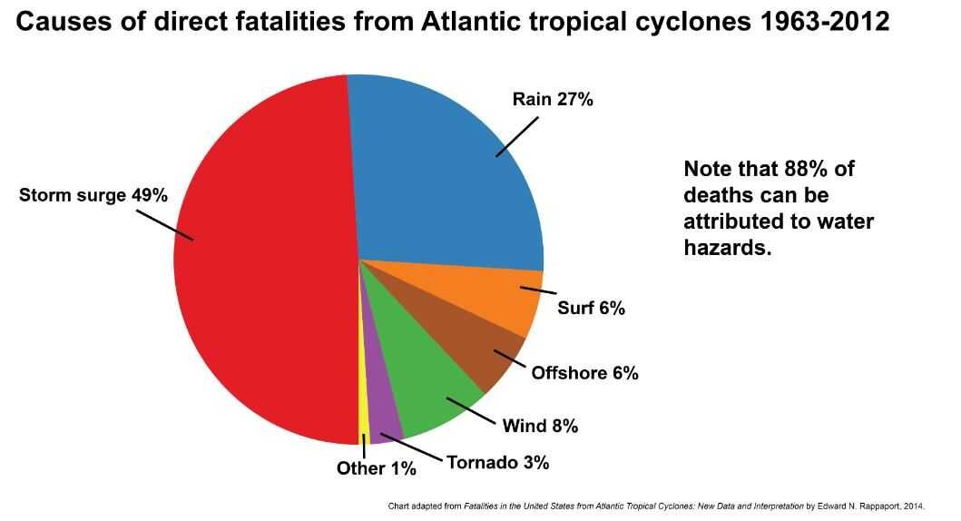
Flooding ranks as the second-leading cause of deaths in a tropical storm. Remember to “Turn Around, Don’t Drown,” when approaching a flooded roadway. As the image below indicates, most tropical-related deaths occur due to high storm surge.