Severe thunderstorms with the potential for a significant tornado outbreak are hitting the US Southeast Wednesday after the National Weather Service’s Storm Prediction Center issued a rare “high risk” level warning.
Long-track, intense tornadoes were expected to begin in parts of Louisiana and Arkansas on Wednesday afternoon and then spread eastward and peak at night in Mississippi and Alabama, the center said. Atmospheric conditions across the region make this threat for tornadoes as bad as it gets.
The high level threat covers 3 million people, and in all, about 45 million people are under a severe weather threat from the storms and could see tornadoes, large hail and damaging winds. Adding to the concern is that nighttime tornadoes can be more dangerous given that people are sleeping and may be unprepared to take immediate shelter.
The risk level for tornadoes and severe storms was raised to the highest possible level — 5 out of 5 — a rare incident, the center says. The last such high risk was issued in May 2019 when the central Plains were hit with dozens of tornadoes and flash flooding.
As of Wednesday afternoon, a line of severe storms had moved into Louisiana and Arkansas, prompting seven separate tornado watches in the broader region covering about 14 million people.
A tornado watch Wednesday evening for eastern Mississippi and much of Alabama was deemed a “Particularly Dangerous Situation,” or PDS, which is issued when the forecaster has high confidence that multiple strong or violent tornadoes (EF2 or higher) will occur in that area.
That replaced two PDS alerts earlier, one for parts of Louisiana, Arkansas and Mississippi, and another for central Mississippi and Alabama.
Individual supercells will begin to develop ahead of that main line of storms from central Mississippi into central Alabama. This will be the most dangerous part of the outbreak, the center said, as these storms typically have the greatest potential to produce long-track, intense tornadoes.
The main line of storms is then expected to continue eastward through Mississippi, Tennessee and Alabama through the evening. It will eventually reach Georgia in the overnight hours and then the Carolinas on Thursday.
A tornado watch means conditions are favorable for a tornado, while a tornado warning is more immediate and means one has been sighted or may be happening.
Possible tornadoes spotted
Severe conditions and potential tornadoes have already been reported in the Southeast.
Josh Pate shot video of a thunderstorm Wednesday afternoon as it crossed US Highway 82 near Billingsley, Alabama, which is about 28 miles northeast of Selma.
The video “shows a rotating thunderstorm and a potential tornado forming,” said CNN meteorologist Brandon Miller.
A confirmed “large and extremely dangerous” tornado was spotted near Shelton State Community College just south of Tuscaloosa at 2:45 p.m., according to the National Weather Service in Birmingham, Alabama. The storm is moving northeast at 30 mph and has previously produced damage and potential injuries in Moundville, according to the National Weather Service.
A tornado warning was issued Wednesday afternoon for the University of Alabama, which urged those on campus to seek shelter immediately.
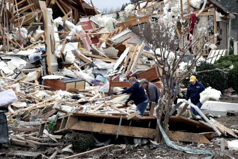
A possible tornado that touched down earlier Wednesday in Wayne County, Mississippi, caused no reported injuries but reportedly damaged two homes and destroyed three chicken houses, according to Angela Atchison of Wayne County Emergency Management. There are also some roads that are blocked due to debris that officials were working to remove.
Authorities warn of “life-threatening” event
The weather service office in Birmingham warned that “strong to violent tornadoes are expected.” Some areas are at a high risk of violent long-track tornadoes, damaging winds of over 80 mph as well as tennis ball-sized hail, the service said.
The Alabama Emergency Management Agency warned the storms could be a “dangerous and life-threatening event.”
The areas threatened Wednesday are no strangers to the danger. The last level 5 risk for Birmingham and Tuscaloosa in Alabama came on April 27, 2011, in an outbreak that featured the most tornadoes in one day, more than 170, and killed more than 300 people, the deadliest tornado day in 75 years.
Alabama Gov. Kay Ivey issued a state of emergency, saying in a statement Tuesday she did so “out of an abundance of caution.”
“Projections are showing that this will likely be a widespread event, with some of the most severe weather anticipated late Wednesday night into early Thursday morning,” Ivey said in a statement.
“Please make preparations now in the event your area is impacted in some way. I will continue keeping a close eye on the system and encourage every Alabamian to do the same,” the governor added.
Other officials also urged residents of the state to prepare.
“Ensure you have multiple ways to receive warnings,” the weather service in Mobile wrote on Twitter. “Also have a plan on a safe place to go should a warning be issued. Please, do NOT focus on the exact risk level. Everybody in the region needs to be prepared for significant severe weather!”