Now downgraded to a Category 1 hurricane, Dorian remains a dangerous storm after smashing the Bahamas, especially for Southern Maryland and the Eastern Shore areas.
While the center of Dorian is expected to pass well southeast of Point Lookout, hazardous impact is expected to extend into St. Mary’s County, Maryland, and nearby waters.
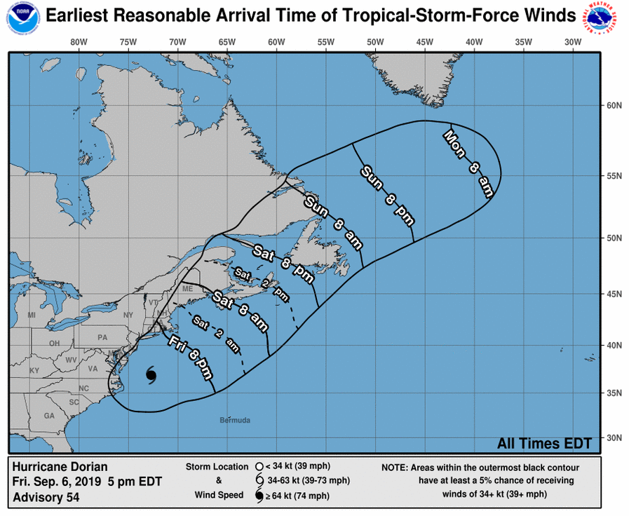
The National Hurricane Center warns of strong winds spreading onshore Friday evening. Those winds mean higher water levels along the shores of the Chesapeake Bay and lower tidal Potomac River.
A few hurricane force gusts are possible along Virginia’s Atlantic coast south of Cape Charles. Strong winds will also continue near the shore of St. Mary’s County in Maryland through Friday evening.
An indirect effect of Dorian is yet to come. Water built up at the mouth of the Chesapeake Bay may come north as winds diminish, potentially causing moderate tidal flooding. Coastal Flood Watches are in effect for Anne Arundel, Calvert, St. Marys, DC and Arlington/Alexandria. pic.twitter.com/aIbO4FqYnh
— NWS DC/Baltimore (@NWS_BaltWash) September 6, 2019
The greatest impact will be right along the coast where Ocean City could see winds of 40 to 50 mph and over an inch of rain, Storm Team4 meteorologist Chuck Bell said.
The “local effects of Dorian will be contained to spotty showers and breezy conditions from near Interstate 95 and points eastward, especially the Northern Neck and southern Maryland and the Eastern Shore,” Storm Team4 meteorologist Matt Ritter said.
With Dorian racing away, the weekend will be nice. Saturday and Sunday will be dry with afternoon highs in the low 80s.
Dorian made landfall at 8:35 a.m. Friday in Cape Hatteras on North Carolina’s Outer Banks before continuing northeast.
Ocean City live webcam:
The Maryland Department of Transportation is preparing for potential flooding along the Eastern Shore and Southern Maryland.
“Even though the path right now is uncertain with Hurricane Dorian, or the remnants of that storm, the (MDOT) State Highway Administration is preparing for the worst, hoping for the best here,” spokesman Charlie Gischlar said Friday.
“There’s gonna be probably some flooding on the lower Eastern Shore and portions of some of the Southern Maryland counties, too. The areas that flood during high tides generally will see some kind of impact from this storm as it transitions from the south and moves out to sea toward the northeast.”
MDOT SHA crews are proactively inspecting and, if necessary, clearing drainage inlets, storm drains and drainage ditches, according to Gischlar.
“Citizens and drivers are urged to watch this very closely and watch the high tide cycle. If you come to an area with water that’s over the roadway, best advice is to turn around, don’t drown. It only takes a couple inches of water to start (moving) a vehicle,” Gischlar said.
The Tropical Storm Warning has been extended northward to Fenwick Island, Delaware, and also extended northward in the Chesapeake Bay to Drum Point, including the Tidal Potomac River south of Cobb Island. St. Mary’s City is also under a Tropical Storm Warning — winds could reach between 39 to 57 mph.
Further down south, Virginia Beach issued a mandatory evacuation order for Sandbridge residents Thursday night. Voluntary evacuation is encouraged for flood-prone, low-lying areas. Swimming on Virginia Beach has also been prohibited.
PLEASE SHARE: ALL public beaches are CLOSED. There is no swimming or wading (or driving) until further notice. #DorianVB
— Virginia Beach (@CityofVaBeach) September 6, 2019
The National Weather Service warned that southeast Virginia could see strong wings, heavy rain, storm surge, flooding and flash flooding.
- Get the latest from the WTOP Weather Center
- How you can help Dorian’s victims
- WATCH: East Coast webcams offer real-time view as Dorian bears down
Virginia Gov. Ralph Northam already declared a state of emergency on Monday, ahead of Dorian’s slow crawl up the East Coast. In anticipation of Hurricane Dorian evacuation traffic coming up Interstate 95, the Virginia Department of Transportation canceled some planned lane closures on Thursday.
Maryland Gov. Larry Hogan commented on Dorian during a Thursday news conference.
“MEMA — Maryland Emergency Management Agency — is in constant communication with all of our local governments,” Hogan said. “Thankfully, we’re not going to be as impacted as many of our neighbors to the south, but it is gonna be an issue for us, and we’re watching it very closely.”

MEMA has increased the state’s activation level, and the State Emergency Operations Center is staffed with emergency management personnel and state agency representatives, according to a news release Thursday.
MEMA Executive Director Russell Strickland urged residents to remain alert and follow officials’ orders, news stations and other weather forecasts.
On Wednesday, the U.S. Navy ordered ships based on Virginia’s coast to head out to sea to avoid Dorian.
Navy spokeswoman Elizabeth Baker said that vessels docked at the world’s largest Navy base in Norfolk and other nearby installations are getting under way.
Vice Admiral Andrew Lewis said in a statement Tuesday that the ships will remain at sea until the threat from the storm subsides. Navy aircraft will either be secured in hangars or fly to more inland airfields.
The Navy’s order follows a similar one made by the U.S. Air Force earlier Tuesday. F-22 Raptor fighter jets and T-38 Talon training planes were ordered to leave Langley Air Force Base in Hampton, Virginia. They’re going to the Rickenbacker Air National Guard Base in Ohio.
Dorian raked the southeastern U.S. coast with howling, window-rattling winds and sideways rain Thursday, knocking out power to more than 200,000 homes and businesses as it pushed northward toward North Carolina’s dangerously exposed Outer Banks.
WTOP’s Teta Alim and Abigail Constantino contributed to this report. The Associated Press contributed to this report.


