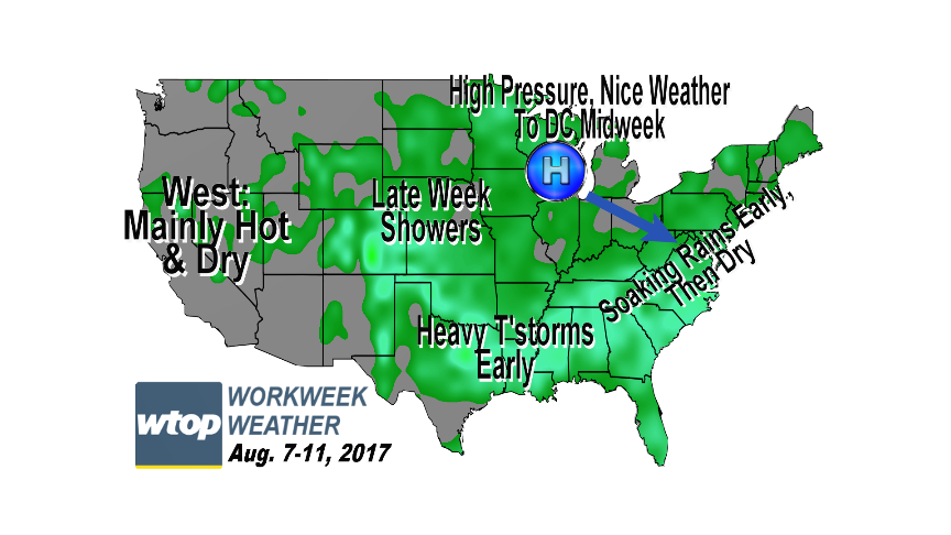
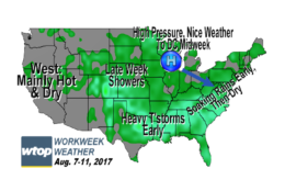
Scattered showers and thunderstorms will kick off the week, but the middle of the workweek will get more sun.
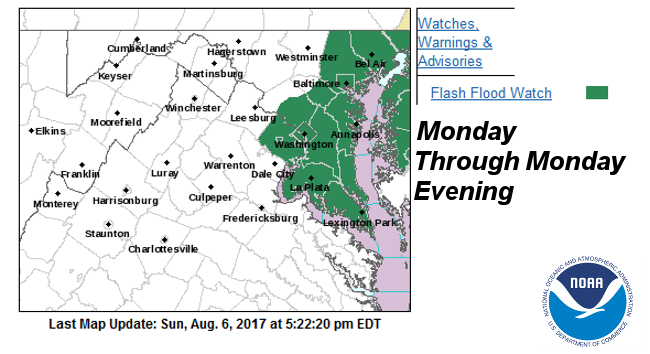
Most of the area is under a Flash Flood Watch for Monday. (National Weather Service, WTOP)
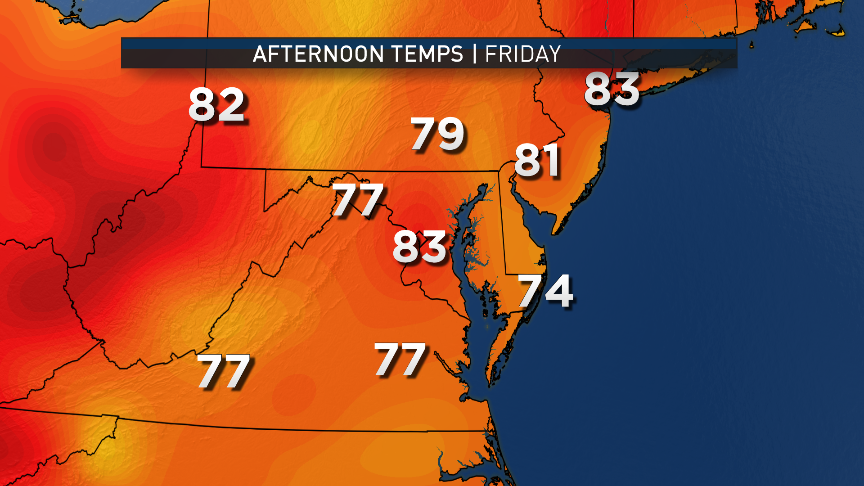
WASHINGTON — The dry, comfortable weekend will already seem like a distant memory as people look for umbrellas to bring to work for Monday’s commutes.
Storm Team 4 will be tracking waves of showers and thunderstorms bringing soaking rainfall to the area. Some of it could be excessive, leading to some more flooding problems for the area’s small streams, creeks and roadways that have poor drainage.
The clusters of storms will move through in a few waves, so in any areas that get under the “train” of storms, the rainfall could be heavy. Since the ground conditions aren’t exactly that dry anymore, it won’t take as much rainfall in a certain period of time to cause drainage problems, so most of the area is under a Flash Flood Watch for Monday. As of this blog writing, the valid areas (which may change through the day) are in the above graphic.Follow the latest weather forecast at the WTOP Weather Center.
The weather will start improving on Tuesday, leading to a warm but pleasant midweek, followed by a chance for more rain for the end of the workweek.
Basically, waves of low pressure will be drawing the cold front that passed through Friday back to the north as a warm front, bringing back more humidity which, of course, is the source for the atmosphere to lift and cause the showers and storms. At the surface, high pressure will be anchored over New England, providing us with northerly and easterly winds, preventing the front to make it through the entire area. It will be one of those scenarios where northern Maryland and mountainous areas could be significantly cooler than the D.C. region and southern areas — and temperatures look like they will be well below average everywhere.
The last wave of low pressure will swing through early Tuesday and take the front back to the south with it. High pressure will build in from the Midwest late Tuesday and Wednesday, leading to a drying trend. Humidity levels will also be dropping. However, because of how much rain will have fallen Monday, the low levels of the atmosphere won’t dry out as much as they could otherwise. Still, the humidity levels will just be the low end of the “sticky” range. The midweek’s temperatures will be back up to average levels in the mid to upper 80s.
The high pressure system will head out to sea for the end of the workweek, allowing for another system to encroach on us Friday — if not Thursday evening — with another chance of rain.
The Nationals are finally back in town this week and have games scheduled every evening. At this point, it looks like Monday’s game may be impacted by the storms and so could Friday’s.
Monday’s rainfall could be a record for the D.C. area, if the “train” of storms heads directly over Reagan National Airport. The record way predates the airport’s days: 1.85 inches set in 1885.
Scattered showers and thunderstorms will kick off the week, but the middle of the workweek will get more sun.
(National Weather Service, WTOP)
National Weather Service, WTOP
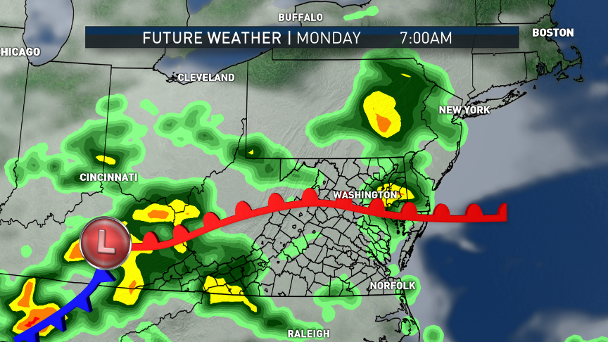
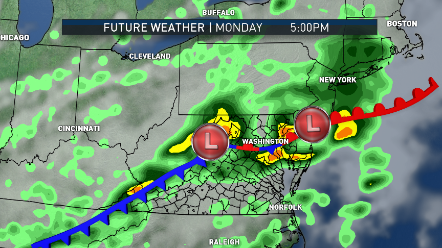
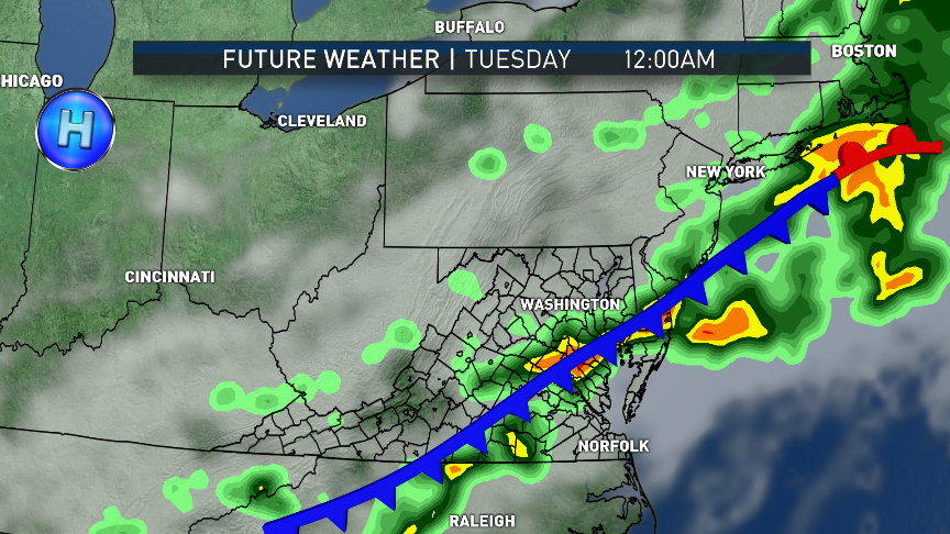
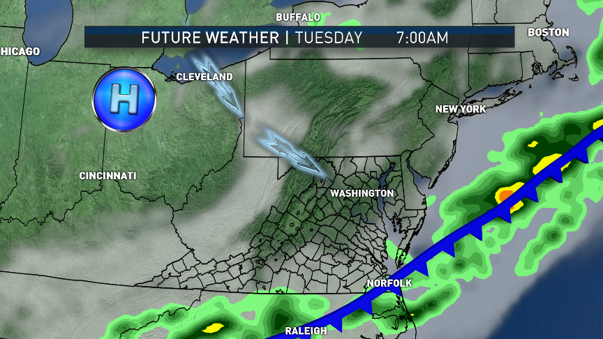
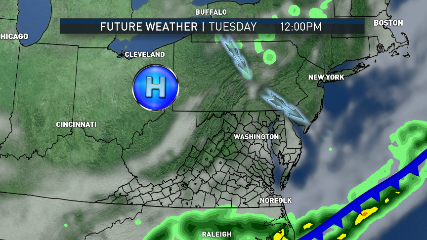
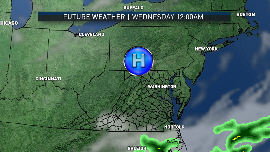
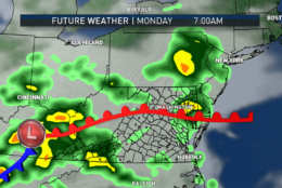
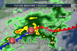
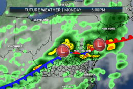
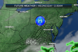
This series of images are from the RPM computer model and they depict the future satellite and radar activity for the evolution of the system for Monday through Wednesday; the fronts and low/high pressure systems are manually added. The heaviest rain in the strongest thunderstorms will accompany the waves of low pressure that will be moving along the front, most likely through Monday evening. The warm front won’t make it all the way through the area, so there will be big temperature variations from the Pennsylvania line to central Virginia and southern Maryland. It will start drying out on northwesterly Tuesday into Wednesday flow courtesy of high pressure.
(Data: The Weather Company. Graphics: Storm Team 4)
Data: The Weather Company. Graphics: Storm Team 4
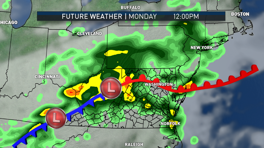
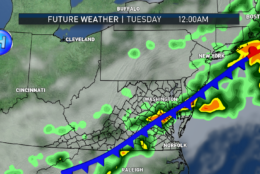
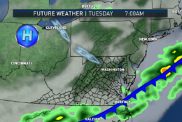
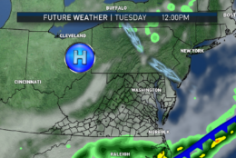
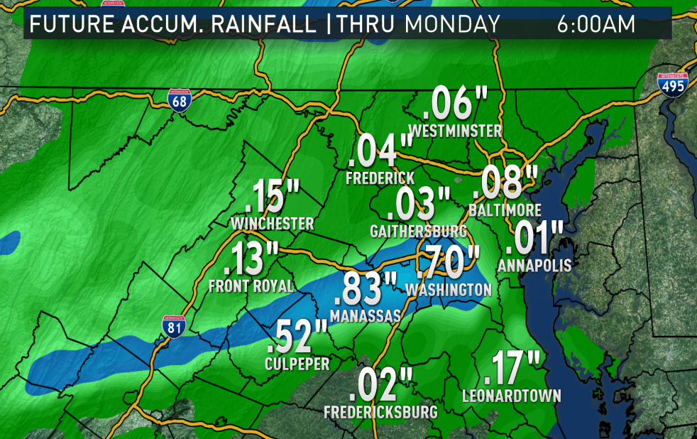
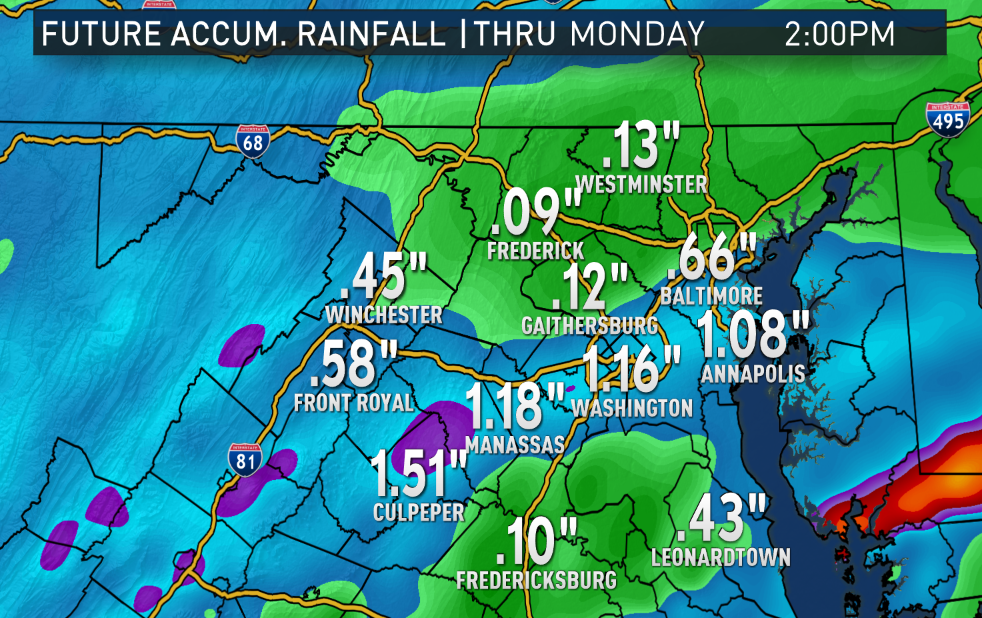
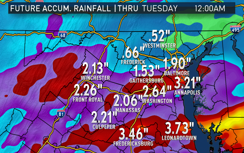
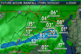
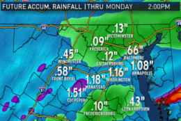
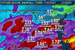
As mentioned, the rainfall could really add up over a wide area, fairly unusual for this time of year without being related to a tropical system. Too much too soon could lead to flash flooding, especially small streams, creeks and roadways. Of course, slight differences in the placement of the warm front could lead to shifts in the exact placement of the heaviest amounts. But the RPM model definitely shows the potential. These graphics are a running total starting Sunday afternoon, the time the model was run. There will already be showers to start the day and most of the accumulating rainfall should be over by early Tuesday morning.
(Data: The Weather Company. Graphics: Storm Team 4)
Data: The Weather Company. Graphics: Storm Team 4
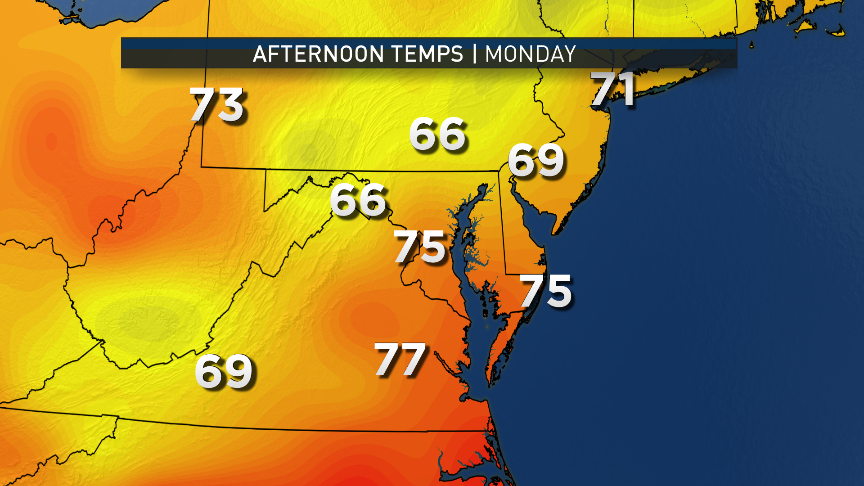
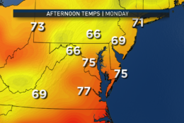
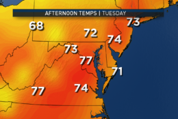
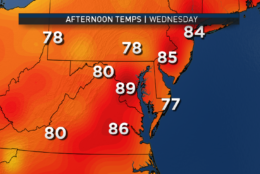
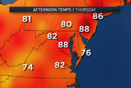
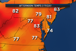
The week will have some temperature swings, mostly due to Monday’s clouds, rain and northeasterly winds. These images are from the American GFS computer model showing that we will be back to average for midweek. Friday may be cooler again with the next arrival of clouds and showers.
(Data: Environmental Modeling Center. Graphics: Storm Team 4)
Data: Environmental Modeling Center. Graphics: Storm Team 4
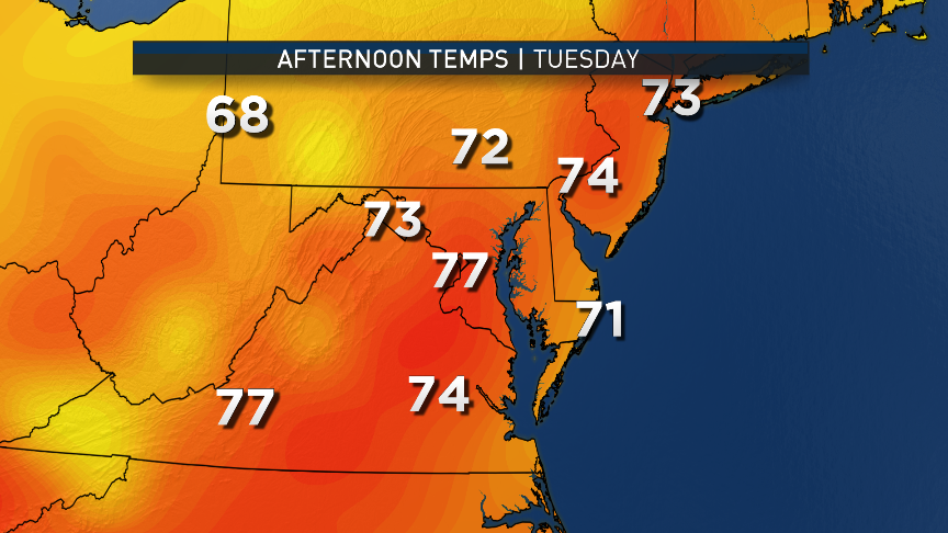
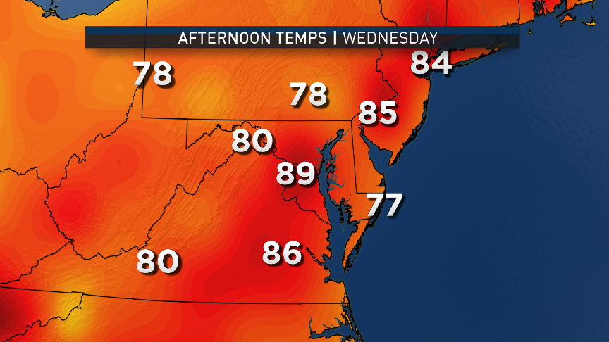
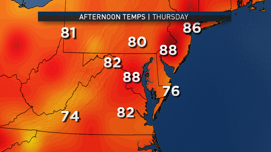
MONDAY
• Bands of showers/thunderstorms already scattered around the area at the start of the day
• Damp, muggy and overcast all day
• Afternoon rain, heavy at times, with some strong or severe thunderstorms, especially south of D.C.
• Evening commute could be much slower than usual
TUESDAY
• Some lingering clouds/scattered showers/fog in the morning
• Clearing skies and a bit breezy
• Warmer than Monday but becoming less humid than Monday
WEDNESDAY
• Lots of sunshine
• Very warm, but seasonably so
• Some humidity but not oppressive at all
THURSDAY
• Sun fading behind increasing clouds toward evening
• Showers possibly arriving as early as late evening, but if not, definitely Friday
FRIDAY
• Cloudy and not as warm, but definitely more humid
• Rain and some thunderstorms
Editor’s Note: The WTOP Workweek Weather Blog is intended as an in-depth yet plain language summary of the business week’s weather potential in the D.C. area along with an explanation of the contingencies and uncertainties that exist at the time of publication. For the latest actual Storm Team 4 forecast, check out the link on the main WTOP Weather Page.