This article was republished with permission from WTOP’s news partner InsideNoVa.com. Sign up for InsideNoVa.com’s free email subscription today. Read the article on Inside Nova.
This article was written by WTOP’s news partner InsideNoVa.com and republished with permission. Sign up for InsideNoVa.com’s free email subscription today.
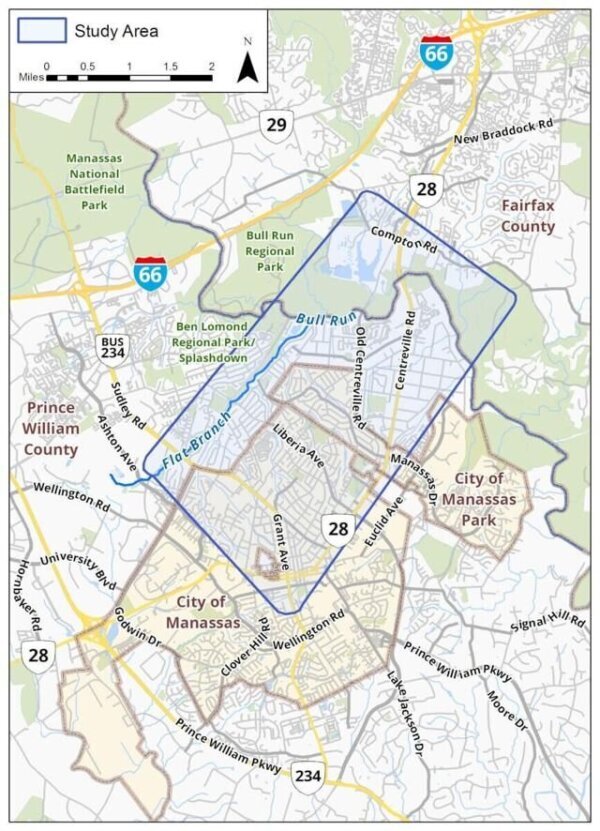
Prince William County transportation officials unveiled a proposed preliminary design for the Route 28 bypass Wednesday night, showing the public for the first time exactly what the road could look like and where exactly its footprint would be.
Heading southwest from Route 28, just south of Compton Road, the $300 million bypass would cut through a small portion of Bull Run Regional Park, over the Bull Run waterway, hug the southern edge of Ben Lomond Regional Park and alongside Flat Branch to its stopping point at Sudley Road and Godwin Drive.
The four-lane, 3.5-mile road design includes three at-grade intersections at Route 28 (which is being widened from four lanes to six between U.S. 29 and Bull Run), Old Centreville Road and Sudley, which is also being widened by the City of Manassas. There will be no tie-in with Lomond Drive, as officials say that would be disruptive to the neighborhood there. A new, longer and taller bridge over Bull Run and through the Bull Run Regional Park would replace the current bridge there.
The typical section of the road would include two lanes in each direction, with a median in the middle and a shared-use path running parallel.
“We are less than 30% designed on this, this is just preliminary,” Prince William Transportation Director Rick Canizales said Wednesday. “We haven’t completed a lot of the final information we need to get a final alignment there. … As soon as we had an alignment together that we felt comfortable with, that we felt comfortable enough to share, we wanted to make sure that we got your comments on it so that we could make sure we’re doing the right thing from the start here.”
Prince William transportation staff said that about 50 parcels would need to be fully taken for the right of way under the design unveiled Wednesday, with more needing partial easements.
They could not say how many individual homes or businesses would actually be impacted by the alignment, but a map showed major impacts to Alleghany Road and Boundary Avenue in Yorkshire and a small portion of land between Ordway Road and Route 28 in Fairfax, at the point where the bypass would meet 28, directly adjacent to where the new Mount Zoar Baptist Church building is being constructed.
A preliminary review of the impacted parcels by InsideNoVa showed 45 homes that would need to be knocked down in Prince William County, going west to east from 7554 Alleghany Ave. to 7410 Boundary Ave., between the street and Bull Run. Several homes in the Bull Run Mobile Home Community would also need to be razed, though the exact impact on that area was less clear. About five other homes would need to be taken in Fairfax.
Prince William officials say the county will help residents whose homes will need to be taken to relocate.
On Wednesday, the county’s department of transportation held a public information meeting at Centreville Elementary School, just north of the bypass’s intersection with Route 28. A little under a mile of the proposed route would be in Fairfax County, with the remainder in Prince William, just north of the Manassas and Manassas Park city limits.
The project is still in its design and engineering phase, and what was presented Wednesday is still considered a preliminary design, potentially subject to change in the future. But for the first time, the county provided information on how big the proposed design’s impact would be on nearby homes.
Intended to alleviate congestion along Route 28, the controversial four-lane road was approved by the Board of County Supervisors in September of 2020. The Northern Virginia Transportation Authority has allocated $89 million for the project. Any costs not covered by the NVTA or other grants would come from a Prince William infrastructure bond referendum approved by voters in 2019.
Preliminary traffic analysis done by the county’s transportation department projects that 25 years out, the project would ease congestion on Route 28, Sudley Road, Liberia Avenue in Manassas and other thoroughfares.
But in and around the two termini of the road, on Centreville Road in Fairfax and Godwin Drive in Prince William, the projections are for slightly worsening traffic. That analysis also included the potential for an eight-lane Route 28 in the area of the bypass, as is currently envisioned by Fairfax’s long-range plan.
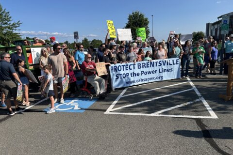
Concerns at Wednesday night’s meeting, attended mostly by Fairfax residents, included increased traffic on the Fairfax side of the project, impacts on Bull Run Regional Park, and potential effects on the Occoquan Reservoirs – from which a portion of Fairfax residents get their drinking water – and its tributaries.
The new bridge over Bull Run and cut-through in Bull Run Regional Park will both be longer than what’s currently there now. Officials said they had to move the alignment slightly west – widening the swath of the park it needs to traverse – in order to keep traffic flowing on the current bridge throughout construction. Ultimately, they’ll give the right of way for the current bridge back to the park, they said.
“It appears on the new drawing that the impacts on the regional park are substantially greater than what we were told initially. The road is wider, the bridge is shifting … further upstream and to the west,” Centreville Road resident Jim Hart said. “There’s gonna be an enormously wide swath of clearing of trees and building up this mound through the park. Whatever chemicals that are in this quantity of fill material that may be leaching out … over time are gonna be running down into the stream and into the reservoir. So water quality in the Occoquan Reservoir, which should be a top priority, is going to be an extremely important issue.”
Transportation officials said they were holding meetings with the Upper Occoquan Service Authority, which handles drinking water from the Occoquan, on the potential designs.
Several Fairfax residents also said they felt shut out from giving their input when the project was being considered in 2020, with the final decision being the Prince William board’s to make.
So far, engineers have completed that preliminary traffic analysis and modeling, the early phases of the required geotechnical field work, as well as flood plain and bridge studies. Next spring, Prince William transportation officials will hold formal public hearings on the design before bringing it to the Fairfax and Prince William boards for endorsements in the fall of 2024. By 2025, officials are planning to have their joint application to the Army Corps of Engineers and the Virginia Department of Environmental Quality ready for submission. If all goes to plan after that, right of way acquisition will begin in 2025, with construction starting in 2026.
Because the project is not being federally-funded, it does not require a formal environmental impact statement or environmental review. But there will be some environmental mitigation required on issues like noise, waterway impact and habitat for endangered species. Officials said on Wednesday that they will need to do their best to blunt the road’s effects on the Northern long-eared bat’s habitat, as it’s an endangered species.
“We’re trying to … minimize our environmental footprint and make sure that we can mitigate all the impacts that we are causing in the area,” Canizales said.
Officials will hold another public information session tonight, April 20, in Manassas Park, with the same information as was provided on Wednesday. The meeting will be held from 6:30 p.m. to 9 p.m. at the Manassas Park Community Center, 99 Adams St.