D.C.-area schools are delaying start times as the region faces its first significant winter storm of the season. And if you were planning on hitting the roads Thursday morning, you might want to consider alternatives.
While the storm Wednesday night won’t be a snow maker, widespread icing on the region’s roadways and freezing rain could create dangerous road conditions into the early hours of Thursday for those in the District, Baltimore and points west of the Interstate 95 corridor.
Storm Team4 meteorologist Amelia Draper said she expects the Interstate 81 corridor to see the worst conditions, with areas north and west of D.C. affected as well.
“During the early morning hours, sleet and freezing rain are both potentially in the forecast,” Draper said. “As we head throughout the day, any ice will change over to plain rain as temperatures warm into the 40s.”
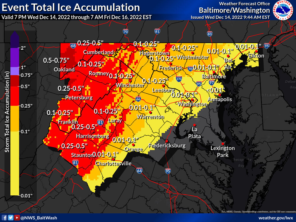
In announcing a Winter Weather Advisory in effect from Wednesday night until Thursday afternoon for the WTOP listening area, the National Weather Service said ice totals of a glaze to around one-tenth of an inch will bog down commuters. A thicker coating of ice is in store for higher elevations of Maryland, Virginia and West Virginia — and residents of the Blue Ridge are under an Ice Storm Warning through Thursday night.
The bottom line: Avoid the roads Thursday morning, if you’re able. If you must venture out before roads can be treated and temperatures warm in the afternoon, remember: Slow down and leave plenty of stopping distance from the vehicle in front of you. Use extra caution on highways, overpasses and bridges. Likewise, be patient with Metro services and aware of potential weather-related delays on public transportation.
- Listen to WTOP online and on the radio at 103.5 FM or 107.7 FM.
- Current traffic conditions
- Weather forecast
- Closings and Delays
- Sign up for WTOP alerts
- What should be in your emergency kit
Wednesday commuters will miss the impact of the storm, as the real trouble starts in the hours after midnight Thursday, when a combination of near-freezing temperatures at the ground and warm air aloft trigger a changeover to freezing rain or sleet. Precipitation will be coming down heavily enough for ice to accumulate rather quickly, and conditions will deteriorate in the hours leading up to daybreak.
Weather-related delays and cancellations
School systems in the D.C. area, including Montgomery County in Maryland and Fauquier County in Virginia, have announced schedule changes Thursday ahead of the winter weather.
You can see the full list of closings and delays here.
“Travel for all areas along and west of the Blue Ridge should be avoided during the overnight and early morning hours, perhaps as late as noon for the I-81 corridor,” Storm Team4 meteorologist Chuck Bell told WTOP.
Ellen Kamilakis, a spokeswoman with the Virginia Department of Transportation, told WTOP that this ice accumulation is most concerning.
“This is worse than snow,” Kamilakis said. “There is no strategy to driving on ice. This is dangerous.”
This warning extends to bus and rail commuters as Metro prepares for potential hazardous conditions around the region.
On Wednesday afternoon, Metro advised customers to remain aware of service impact, including delays and detours mapped out in the transit service’s light snow plan.
“Metro is keeping an eye on the sky and advising customers to be prepared for potential service impacts to Metrobus service tomorrow, Dec. 15, if icy conditions materialize,” Metro wrote in an email to patrons. It added that MetroAccess would continue its normal operations Thursday, allowing extra travel time as needed.
Near the District, an influx of warmer air from the storm’s center prompts a switch back to rain around mid to late Thursday morning. Temperatures remain above freezing overnight Friday for all but the region’s highest elevations, so travel issues for Friday commuters should be limited to wet pavement.
“The I-95 corridor should be all rain after 9 a.m., and even the I-81 corridor should be above freezing by noon,” Bell said. “A steady rain, moderate at times, will remain well into the late evening hours.”
WEATHER ALERT! Dry today but a long period of sleet, freezing rain and rain will have a high impact on our area tomorrow. The main threat will be sleet in metro DC and freezing rain for area along and West of the Blue Ridge and the I-81 corridor. Stay home Thurs if you can. pic.twitter.com/Zf1wNs53Y0
— Chuck Bell (@ChuckBell4) Dec. 14, 2022
Storm preparation continues
Local transit officials spent the last day preparing for the storm’s approach. The Virginia Department of Transportation is mobilizing its equipment and resources, including salt and sand trucks, to control the spread of ice. D.C.’s snow team deployed Tuesday night to treat vulnerable road surfaces with salt, brine and raw beet juice. Maryland’s Department of Transportation said its crews are also using salt brine and water to lessen the impact of ice on the road.
The storm is a great opportunity for a refresher on winter weather preparedness, even if early predictions aren’t bullish on snowfall this season. WTOP’s Chad Merrill has a helpful guide on tips — and common misconceptions — when navigating an ice storm, including:
- Beware of black ice: Ice is difficult to spot, especially in the dark. If you see shiny surfaces, assume it’s ice.
- Sights can be deceiving: Judging an ice storm by the degree of glazing on tree branches can lead to a false sense of security, since ice often gathers faster and thicker on flatter surfaces like roads and cars.
- Don’t forget about fog: Warm air moving over a cold ground makes fog more likely, which reduces visibility in turn. Remember to use your low beams.
Accumulation of ice on wires and branches means scattered power outages are also a possibility.
“Travel is strongly discouraged. If you must travel, keep an extra flashlight, food and water in your vehicle in case of an emergency,” the weather service said. “Prepare for possible power outages. When venturing outside, watch your first few steps taken on steps, sidewalks, and driveways, which could be icy and slippery, increasing your risk of a fall and injury.”
For the latest road and traffic conditions, see WTOP’s traffic page or listen to updates every 10 minutes online or on the air at 103.5 FM. Download the free WTOP News app for Android and Apple phones to sign up for custom traffic and weather alerts.
Forecast:
Wednesday night: Sleet, freezing rain and rain. Up to a tenth of an inch of ice accumulation west of I-95, with mostly rain east. Overnight lows in the upper 20s to near freezing.
Thursday: Sleet and rain early, changing to all rain by noon. Moderate rain through sunset. Highs in the mid-30s to low 40s.
Friday: Partly cloudy and breezy at times. Chilly, with highs in the low to mid-40s.
Saturday: Partly cloudy and cold. Highs in the low to mid 40s.