The first, full workweek after the holidays will feature a single-digit start for most of the area during the Monday morning rush and, quite possibly, some defrosting of the windshields will need to be done.
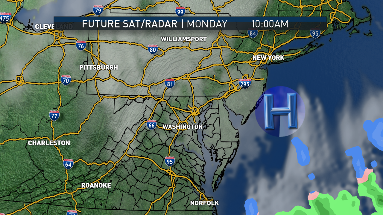
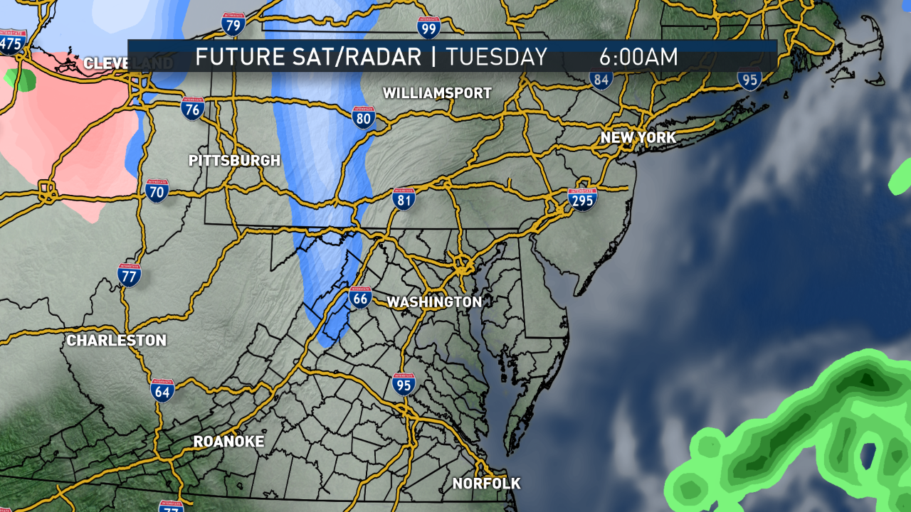
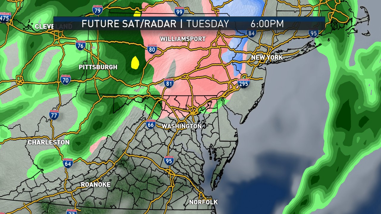
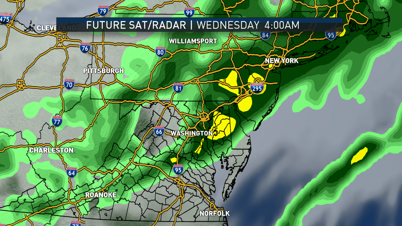
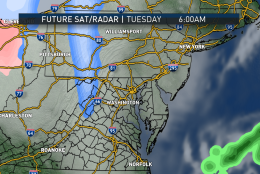
This series of images is from the RPM computer model run on Sunday afternoon. Monday is just showing the mid- and high-level clouds moving through from southwest to northeast as the center of high pressure heads out to sea. No precipitation with those clouds. As a warm front approaches on Tuesday, some light precipitation moves from west to east but mostly to the north, and it could start off as some flurries in the far northwest suburbs in the morning. There may be a wintry mix right along the Mason-Dixon Line to watch the rest of the day, but most will stay dry. Tuesday night into Wednesday morning, the warm air will win out and the area will just get some plain rain. A similar system not pictured because it’s beyond the limits of this particular model would bring more rain Thursday morning.
(Data: The Weather Company. Graphics: Storm Team4)
Data: The Weather Company. Graphics: Storm Team4
As a warm front approaches on Tuesday, some light precipitation moves from west to east but mostly to the north, and it could start off as some flurries in the far northwest suburbs in the morning.
(Data: The Weather Company. Graphics: Storm Team4)
Data: The Weather Company. Graphics: Storm Team4
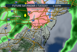
There may be a wintry mix right along the Mason-Dixon Line to watch the rest of the day, but most of the area will stay dry. Tuesday night into Wednesday morning, the warm air will win out and there will be plain rain.
(Data: The Weather Company. Graphics: Storm Team4)
Data: The Weather Company. Graphics: Storm Team4
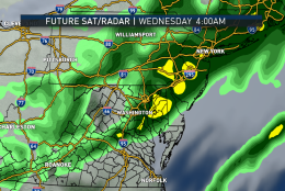
Tuesday night into Wednesday morning, the warm air will win out and the area will get some rain.
(Data: The Weather Company. Graphics: Storm Team4)
Data: The Weather Company. Graphics: Storm Team4
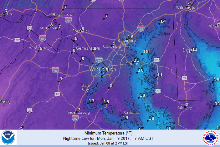
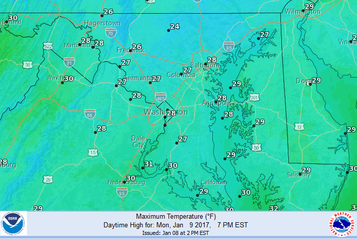
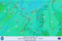
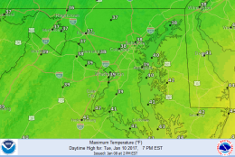
This series of images is the forecast from the National Weather Service for the area this week, and the low temperatures early Monday morning. These images are being shared because the raw computer output from the various models may be too warm, considering there won’t be much if any sun in this week’s pattern. But nonetheless, these numbers will be well above average.
(Courtesy National Weather Service, NOAA)
Courtesy National Weather Service, NOAA
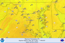
This series of images is the forecast from the National Weather Service for the D.C. area this week, and the low temperatures early Monday morning. These images are being shared because the raw computer output from the various models may be too warm, considering there won’t be much if any sun in this week’s pattern. But nonetheless, these numbers will be well above average.
(National Weather Service, NOAA)
National Weather Service, NOAA
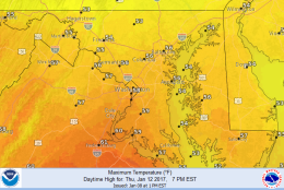
This series of images is the forecast from the National Weather Service for the area this week, and the low temperatures early Monday morning. These images are being shared because the raw computer output from the various models may be too warm, considering there won’t be much if any sun in this week’s pattern. But nonetheless, these numbers will be well above average.
(National Weather Service, NOAA)
National Weather Service, NOAA
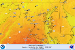
This series of images is the forecast from the National Weather Service for the area this week, and the low temperatures early Monday morning. These images are being shared because the raw computer output from the various models may be too warm, considering there won’t be much if any sun in this week’s pattern. But nonetheless, these numbers will be well above average.
(National Weather Service, NOAA)
National Weather Service, NOAA
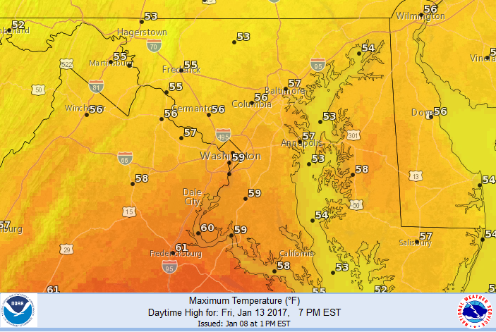
This series of images is the forecast from the National Weather Service for the WTOP listening area this week, and the low temperatures early Monday morning. These images are being shared because the raw computer output from the various models may be too warm, considering there won’t be much if any sun in this week’s pattern. But nonetheless, these numbers will be well above average.
(National Weather Service, NOAA)
WASHINGTON — The first, full workweek after the holidays will feature a single-digit start for most of the area during the Monday morning rush and, quite possibly, some defrosting of the windshields will need to be done.
High pressure will have settled in Sunday night, allowing for mainly clear skies and calm winds, leading to the bottom falling out of the thermometer (also due to the presence of the snowpack).
This dome of high pressure will depart the area Monday evening; and while a new one drops from central Canada into the middle of the country, a big warm-up will set up in the East, including our area.
A significant ridge in the jet stream winds aloft will take shape, and gradually southwest flow at the surface and aloft will bring in warmer temperatures. A deep trough (dip) will form in the middle of the country, keeping cold storminess out west.
The jet stream will send several disturbances our way this week bringing several chances for precipitation. The first disturbance will affect us on Tuesday mainly with cloudy skies. A swath of rain possibly mixed in with sleet and freezing rain will skirt the Pennsylvania state line. Some northern Maryland areas could pick up some of this up, but it will be close.
The rest of the area will start getting back above freezing. Then rain will move in Tuesday night and Wednesday morning. Another disturbance will do the same roughly 24 hours later and with even warmer temperatures.
A strong cold front will finally break the pattern down on Friday, and the arctic high pressure system in the middle of the country will shift to eastern Canada. Northerly winds will filter in much colder air late in the day Friday and that scenario will last into the weekend.
Daily weather highlights
Monday
Frigid and possibly frosty start
Not as blustery but still below freezing for most of us all day
Lots of mid- and high-level clouds
Tuesday
Overcast and still chilly, but closer to seasonable
Some snow or ice probable just north of the area in Pennsylvania into New England
Areas with the thickest snowpack start getting slushy from snowmelt
Patchy fog
Wednesday
Light rain and drizzle in the morning
Cloudy and damp the rest of the day
Milder than average
Most if not all the area’s snowpack melted
Thursday
More light rain and drizzle, most likely in the morning
Temperatures well above average, feeling almost springlike
Friday
Mix of clouds and sun
Unseasonable warmth continues, but temperatures start dropping again late in the day
Editor’s note: The WTOP Workweek Weather Blog is intended as an in-depth yet plain language summary of the business week’s weather potential in the D.C. area along with an explanation of the contingencies and uncertainties that exist at the time of publication. For the latest, actual Storm Team 4 Forecast, check out the WTOP Weather Page.