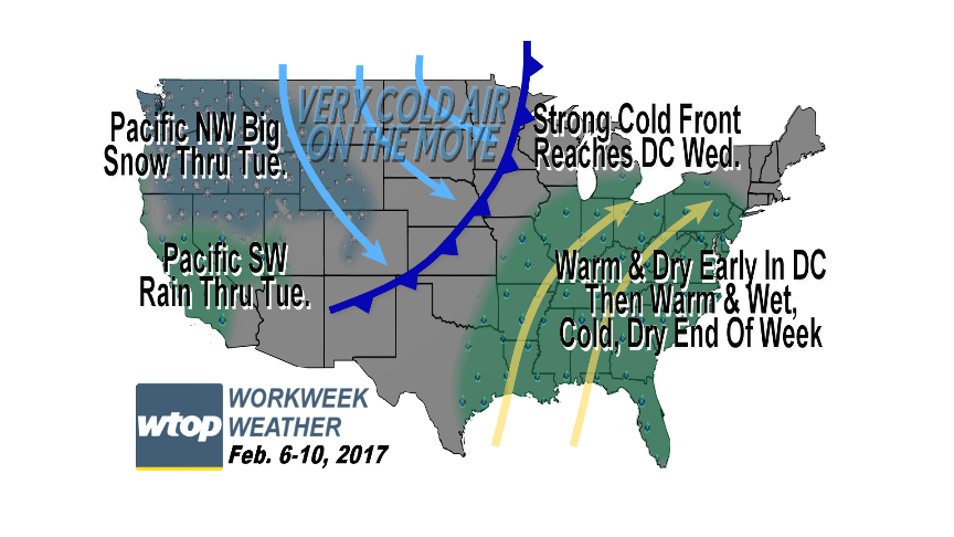
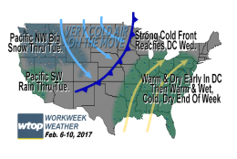
After a cold start Monday, mild temperatures are on the way for a few days before colder air comes roaring back for the end of the workweek.
After a cold start Monday, mild temperatures are on the way for a few days before colder air comes roaring back for the end of the workweek.
(WTOP/Storm Team 4)
WTOP/Storm Team 4
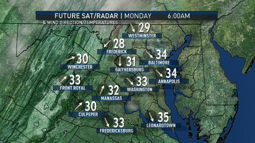
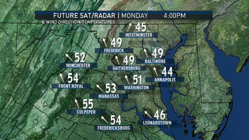
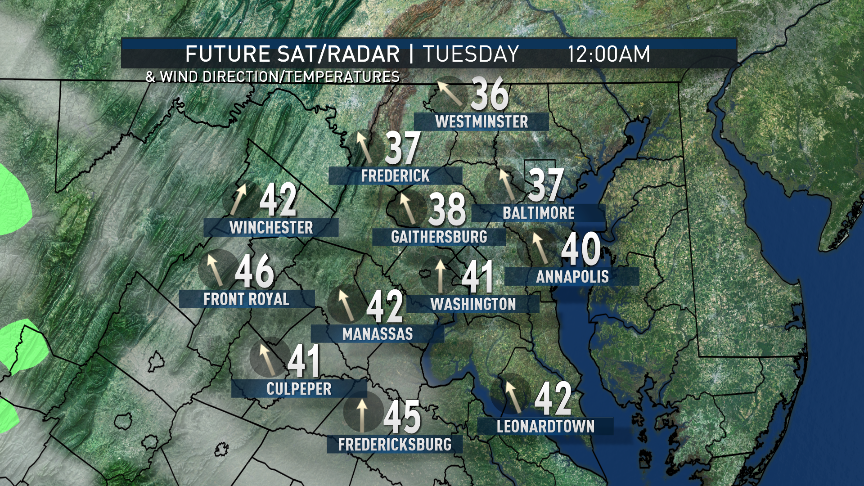
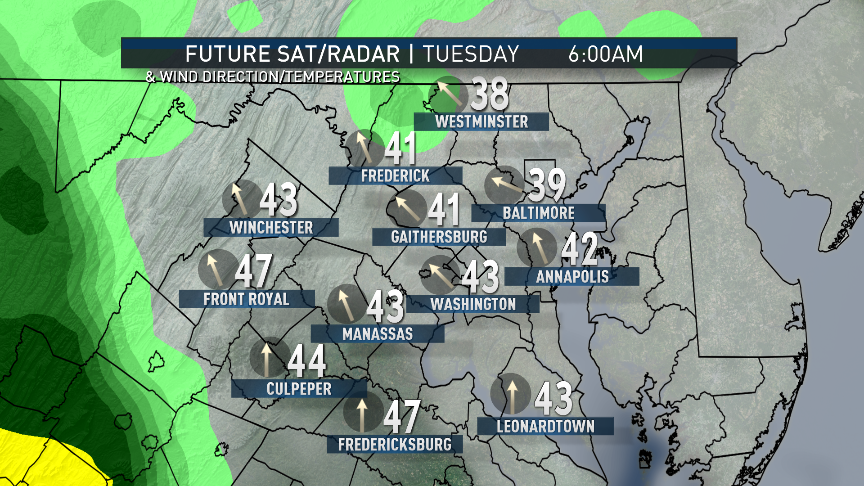
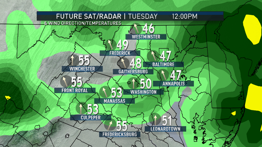
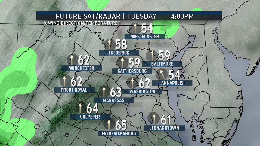
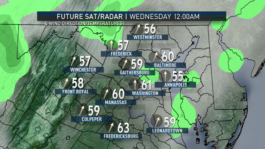
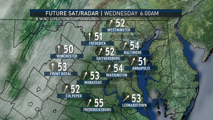
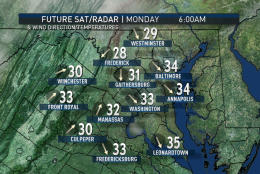
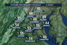
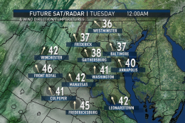
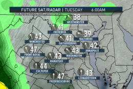
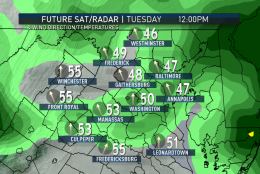
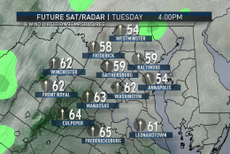
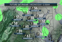
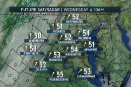
These following maps are from the RPM computer model showing the future simulation of clouds, weather-type radar, surface temperatures and surface wind direction at certain times of day. They show the cold start to Monday followed by the warm frontal passage Tuesday morning and the rapidly rising temperatures. The future radar shows only rain as the precipitation type. Notice how warm it could stay Tuesday night. This particular model run stops Wednesday morning just before the strong cold front is getting ready to move through the area from our northwest.
(Data: The Weather Company; Images: Storm Team 4)
Data: The Weather Company; Images: Storm Team 4
(Data: The Weather Company; Images: Storm Team 4)
Data: The Weather Company; Images: Storm Team 4
(Data: The Weather Company; Images: Storm Team 4)
Data: The Weather Company; Images: Storm Team 4
(Data: The Weather Company; Images: Storm Team 4)
Data: The Weather Company; Images: Storm Team 4
(Data: The Weather Company; Images: Storm Team 4)
Data: The Weather Company; Images: Storm Team 4
(Data: The Weather Company; Images: Storm Team 4)
Data: The Weather Company; Images: Storm Team 4
(Data: The Weather Company; Images: Storm Team 4)
Data: The Weather Company; Images: Storm Team 4
(Data: The Weather Company; Images: Storm Team 4)
Data: The Weather Company; Images: Storm Team 4
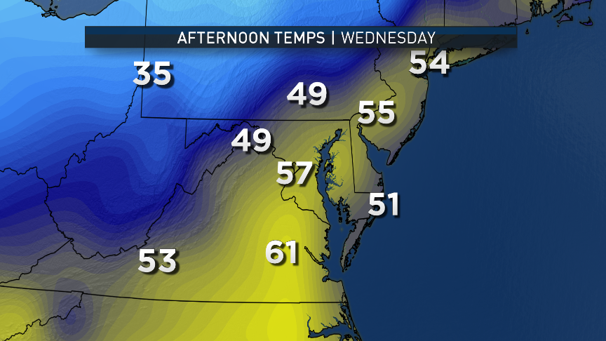
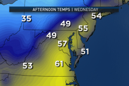
Here are maps of the GFS computer model showing afternoon snapshots of surface temperatures Wednesday through Friday. Note the sharp contrast in warmth and cold on Wednesday. That’s an indication of how rapid the cool down will be once the front moves through. But timing the front this far in advance is difficult. It is unlikely to be faster than shown, but the mountains could slow it up a bit. Any delay in the arrival of the front could mean another day of very warm temperatures here, like are shown just to our south.
(Data: Environmental Modeling Center, NOAA; Graphics: Storm Team 4)
Data: Environmental Modeling Center, NOAA; Graphics: Storm Team 4
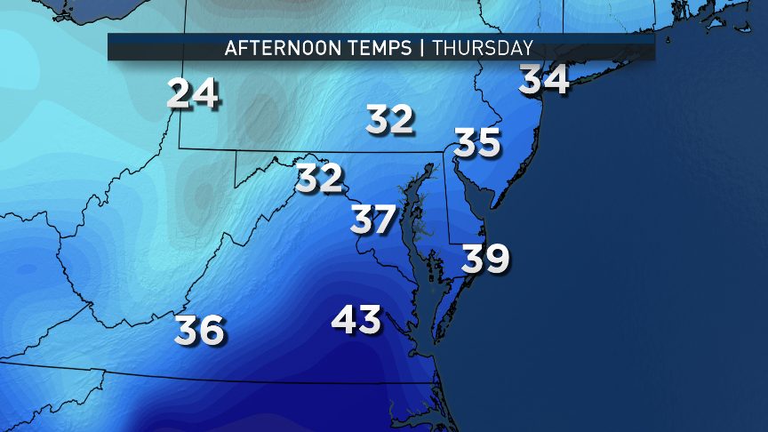
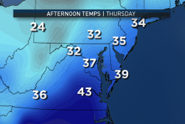
But after that, no matter what, the colder air by comparison takes over for Thursday and Friday. Also notice the possible temperatures Thursday definitely make for a cold rain if the moisture becomes available, but not necessarily snow.
(Data: Environmental Modeling Center, NOAA; Graphics: Storm Team 4)
Data: Environmental Modeling Center, NOAA; Graphics: Storm Team 4
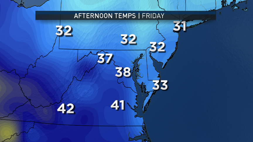
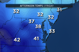
Friday is chilly but dry.
(Data: Environmental Modeling Center, NOAA; Graphics: Storm Team 4)
Data: Environmental Modeling Center, NOAA; Graphics: Storm Team 4
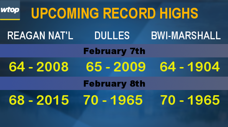
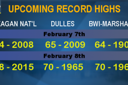
Speaking of records, this graphic lists them for the big airports for Tuesday and Wednesday of this week. Tuesday’s are in play. Wednesday’s likely are not, but again, it depends on the speed of that front. It’s worth mentioning that the vast majority of February record high temperatures are in the 70s. These records in the low to mid 60s are that “high” by comparison.
(WTOP/Storm Team 4)
WASHINGTON — The new workweek kicks off with a cold start as Monday morning’s temperatures will be close to the freezing point, which is perfectly average for this time of year. But very mild temperatures are on the way for a few days before colder air comes roaring back for the end of the workweek.
High pressure moving off the East Coast will help set up a southerly flow and Arctic high pressure spilling into the Rockies and the Plains will push a strong cold front through the Midwest, enhancing the southerly flow out ahead of the front. That will mean near record high temperatures for us on Tuesday. Wednesday will be a “day of transition” with the strong cold front going through. Then Thursday and Friday will be brisk and much colder, near seasonable temperatures or slightly below.
In terms of precipitation, some moisture will accompany a warm front on Tuesday, especially in the morning. It will move pretty quickly, and the best energy and “lift” in the atmosphere will be north of here, so we’re only looking at a few tenths of an inch of rain.
The cold front Wednesday should pass through without precipitation, but a wave of low pressure developing on the southern end of the front may push a cold rain mixed in with some wet snow just far enough north to affect us late Wednesday or Thursday. There is little consensus in the computer guidance on that secondary wave of low pressure, so at this point, it’s just something to track in the early part of the week. Also at this point, even in a worst-case realistic scenario, it doesn’t look like that little low would have much impact from snow, just rain. But, again, how much precipitation is yet to be determined.
Daily weather highlights
MONDAY
• Clear, cold start
• Lots of high-level clouds later in the day
• Pleasantly mild, slightly above averages
• Skies become overcast overnight
TUESDAY
• Showers, drizzle and patchy fog in the morning
• Peeks of sun in the afternoon
• Temperatures soaring into the 60s; near record warmth
• Strong breezes out of the south, especially in the mountains
• Staying mild overnight
WEDNESDAY
• Depending on the speed of the front, another warm day or just mild in the morning with falling temperatures in the afternoon
• Temperatures definitely falling in the evening and falling sharply overnight
THURSDAY
• Cloudy, breezy and colder-than-average temperatures
• Chance of rain possibly mixed with wet snow
• Little snow impact anticipated at this time, but could be enough rain to slow commutes
Editor’s Note: The WTOP Workweek Weather Blog is intended as an in-depth yet plain language summary of the business week’s weather potential in the D.C. area along with an explanation of the contingencies and uncertainties that exist at the time of publication. For the latest actual Storm Team 4 forecast, check out the main WTOP Weather Page.