Workweek weather: Nor’easter will bring soaking rains

This series of images shows the progression of the storm up the coast, as a rainmaker for the D.C. area, then pulling in and generating just enough cold air for some wet snow in the mountainous regions up into New England. The computer model used to show the future clouds and winter radar is the RPM run Sunday afternoon. The low is coming out of the Southeast on Monday morning, redeveloping off the coast of the Mid-Atlantic Monday evening, then heading up to New England on Tuesday. (Data: The Weather Company. Graphics: Storm Team 4)
This series of images shows the progression of a storm up the coast, a rainmaker for the D.C. area, that is pulling in and generating just enough cold air for some wet snow in the mountainous regions up into New England. The computer model used to show the future clouds and winter radar is the RPM run Sunday afternoon. The low is coming out of the Southeast on Monday morning, redeveloping off the coast of the Mid-Atlantic Monday evening, then heading up to New England on Tuesday. (Data: The Weather Company. Graphics: Storm Team4)
(Data: The Weather Company. Graphics: Storm Team 4)
(Data: The Weather Company. Graphics: Storm Team4)
(Data: The Weather Company. Graphics: Storm Team 4)
(Data: The Weather Company. Graphics: Storm Team4)
(Data: The Weather Company. Graphics: Storm Team 4)
(Data: The Weather Company. Graphics: Storm Team4)
(Data: The Weather Company. Graphics: Storm Team 4)
(Data: The Weather Company. Graphics: Storm Team4)
How will it all add up? The same run of the RPM shows the good potential of very beneficial rainfall amounts. (Data: The Weather Company. Graphics: Storm Team 4)
How will it all add up? The same run of the RPM shows the good potential of very beneficial rainfall amounts. (Data: The Weather Company. Graphics: Storm Team4)
And how about those winds? Remember, that the term nor'easter refers to the strong northeasterly direction of the winds in advance and during the first half, or so, of a storm's duration. Also from the same run of the RPM, notice the next series of images how winds shift from northeasterly to northwesterly when we start to dry out and cool down again on Tuesday. Wind speeds also will be diminishing by then. Keep in mind that these are predicted average wind speeds. There will be much higher gusts, especially on Monday morning through afternoon, and the values are in miles per hour. (Data: The Weather Company. Graphics: Storm Team 4)
And how about those winds? Remember, that the term nor’easter refers to the strong northeasterly direction of the winds in advance and during the first half, or so, of a storm’s duration. Also from the same run of the RPM, notice the next series of images how winds shift from northeasterly to northwesterly when we start to dry out and cool down again on Tuesday. Wind speeds also will be diminishing by then. Keep in mind that these are predicted average wind speeds. There will be much higher gusts, especially on Monday morning through afternoon, and the values are in miles per hour. (Data: The Weather Company. Graphics: Storm Team4)
(Data: The Weather Company. Graphics: Storm Team 4)
(Data: The Weather Company. Graphics: Storm Team4)
(Data: The Weather Company. Graphics: Storm Team 4)
(Data: The Weather Company. Graphics: Storm Team4)
(Data: The Weather Company. Graphics: Storm Team 4)
(Data: The Weather Company. Graphics: Storm Team4)
(1/10)
This series of images shows the progression of the storm up the coast, as a rainmaker for the D.C. area, then pulling in and generating just enough cold air for some wet snow in the mountainous regions up into New England. The computer model used to show the future clouds and winter radar is the RPM run Sunday afternoon. The low is coming out of the Southeast on Monday morning, redeveloping off the coast of the Mid-Atlantic Monday evening, then heading up to New England on Tuesday. (Data: The Weather Company. Graphics: Storm Team 4)
(Data: The Weather Company. Graphics: Storm Team 4)
How will it all add up? The same run of the RPM shows the good potential of very beneficial rainfall amounts. (Data: The Weather Company. Graphics: Storm Team 4)
And how about those winds? Remember, that the term nor'easter refers to the strong northeasterly direction of the winds in advance and during the first half, or so, of a storm's duration. Also from the same run of the RPM, notice the next series of images how winds shift from northeasterly to northwesterly when we start to dry out and cool down again on Tuesday. Wind speeds also will be diminishing by then. Keep in mind that these are predicted average wind speeds. There will be much higher gusts, especially on Monday morning through afternoon, and the values are in miles per hour. (Data: The Weather Company. Graphics: Storm Team 4)
(Data: The Weather Company. Graphics: Storm Team 4)

WASHINGTON — Last year at this time the region was dealing with a blizzard. Well, this year, there are clouds and wind, but no cold air.

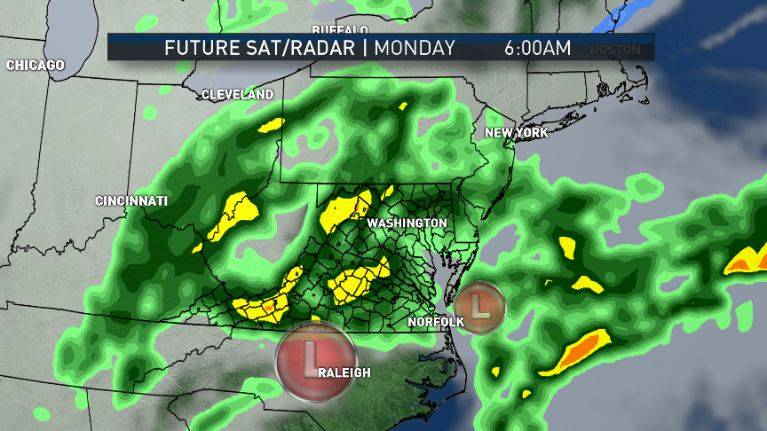
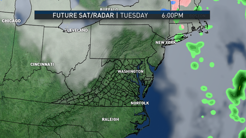
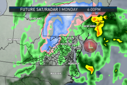
The new work week starts with a nor’easter. It’s moving up the mid-Atlantic coast and bringing the area a much-needed big precipitation “event” — but that “event” will just be a rainstorm for the area.

Snow lovers will, no doubt, be disappointed by that. But, ultimately, the area needs the precipitation in one form or another to lessen the effects of the drought.

Effects of  storm in southeast US

Sunday’s severe weather in the southeastern U.S. mostly will be over by the time this story is published early Monday. But the same storm system will affect D.C.

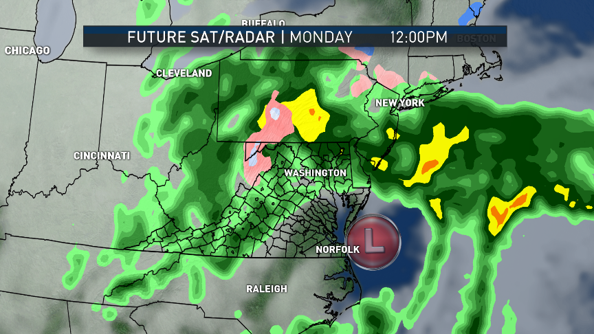
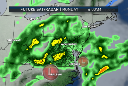
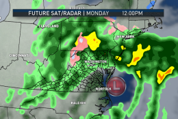
The severe weather occurred while all the ingredients in the atmosphere were setting up the structure of a large-scale, low-pressure system destined to head up the mountains and then the coast. The circulation of the storm will tap abundant moisture from the Gulf and from the Atlantic. Waves of rain bands will rotate around the center and pass over us.

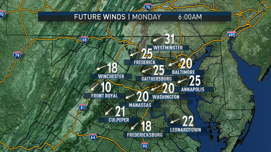
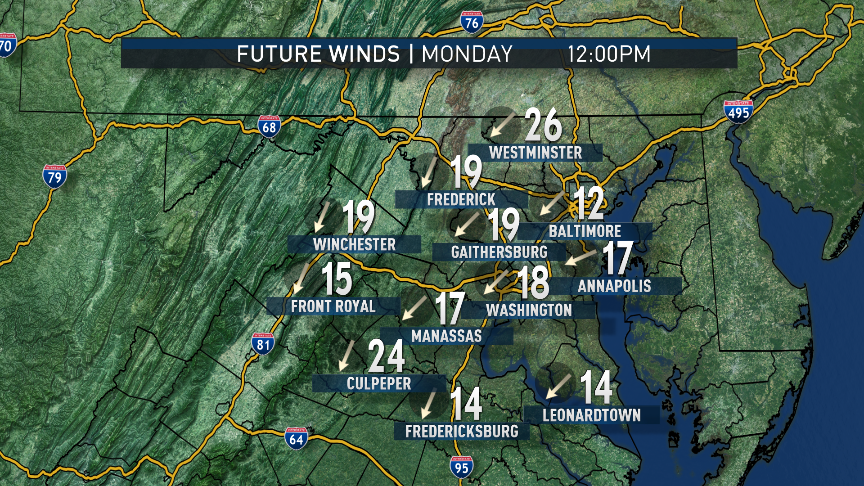
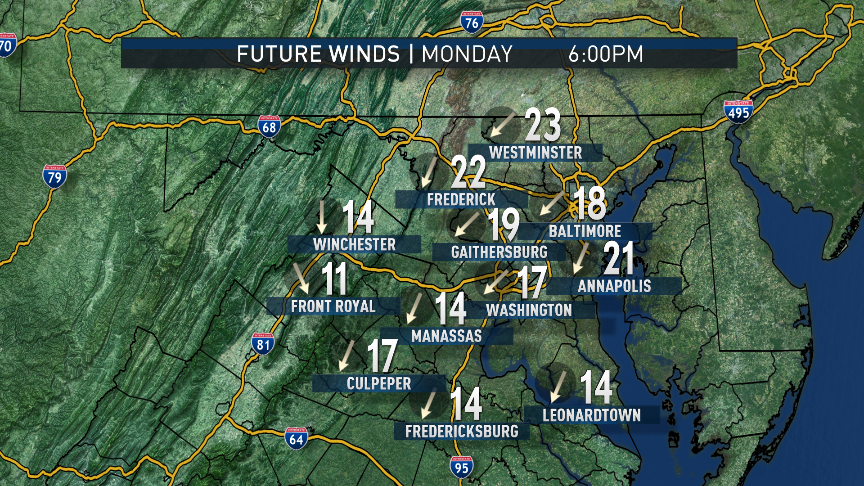
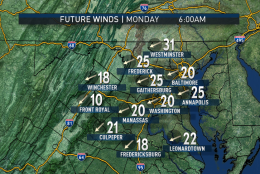
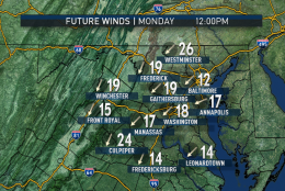
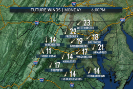
At the same time, the deepness of the low pressure, itself, will cause strong gusty winds — the strongest of which will be along the coastal regions. Wind speeds here at home will average between 20 to 30 miles per hour, with gusts over 40 mph at times.

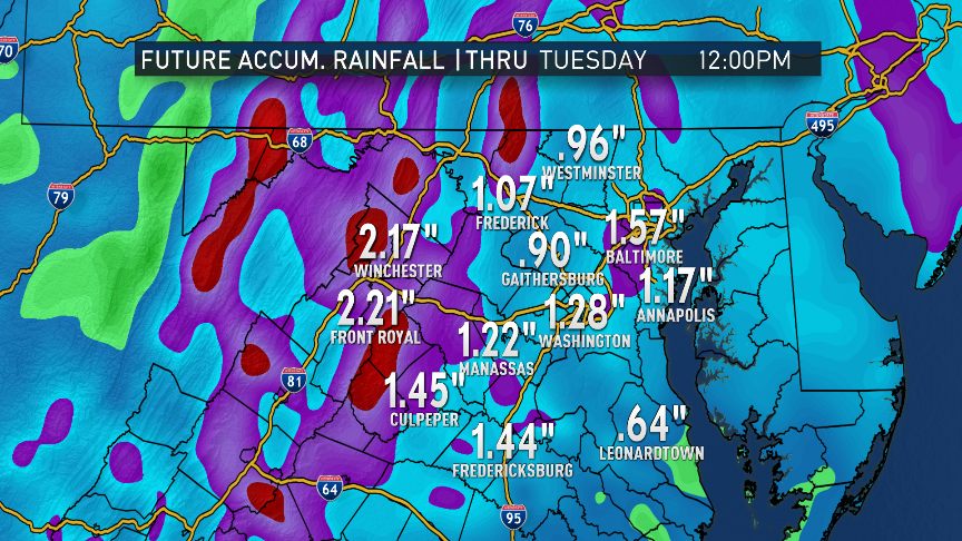
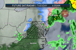
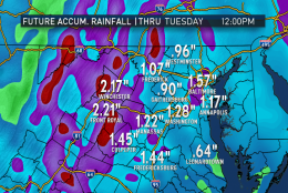
And, it still looks like 1 to 3 inches of rainfall will be possible over the entire WTOP listening area by the time all the rain ends early Tuesday.

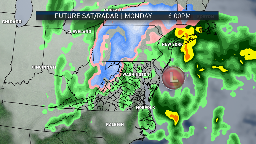
Temperatures will be quite mild during this whole storm, especially east of the Blue Ridge. But some of the cold air may remain trapped in some of the valleys of the mountains west of Interstate 81. Eventually, colder air will wrap into the storm via northwesterly winds, which could cause some wet snowflakes to mix into the rain. But that’s most likely in interior West Virginia, far Western Maryland and parts of Pennsylvania. It will be something we’ll have to monitor through the day on Monday.

Uneventful rest of the week

Even with all this rain, flooding is not much of a concern because of how low the area’s streams and rivers are. If there’s any flooding, it would be minor and mainly in urban areas or highways, which have poor drainage in the first place.

The rest of the week will be fairly uneventful.

A weak cold front will pass through the area Wednesday, helping to dry us out even more. There will be enough sun before the front gets here that temperatures will be mild again. The cold air mass behind the front is not Arctic, so temperatures will only be falling to seasonable levels, but they will start falling rapidly Wednesday evening.

There are some indications in the longer range computer models that Arctic air may be on the move again around the time February comes around. Maybe that will help snow lovers get a storm around here.

Daily weather highlights

Monday

  • Windswept rain
  • Mild temperatures, especially in central Virginia and southern Maryland
  • Cooler temperatures northwest of D.C.
  • Heaviest, steadiest rain bands taper off in the evening and overnight

Tuesday

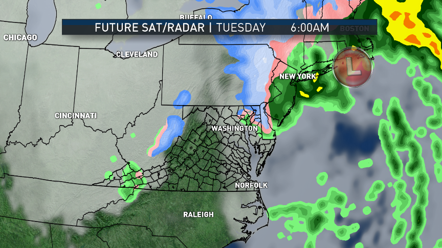
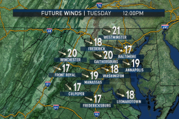
  • Early morning lingering showers and drizzle
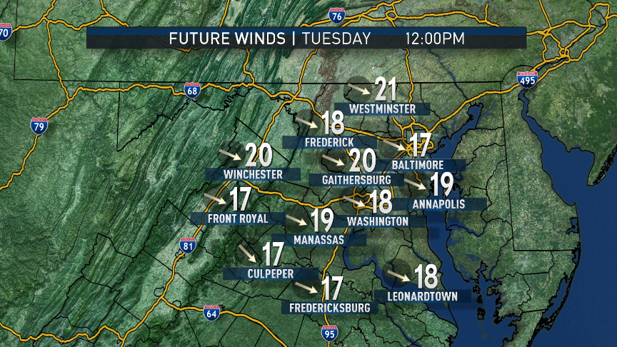
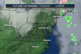
  • Not as windy, but still breezy
  • Sun peeking through the clouds

Wednesday

  • Sunshine and mild until clouds arrive with front in the afternoon
  • A bit breezy and turning colder in the evening

Thursday

  • Mix of clouds and sun
  • Slightly higher-than-average temperatures, not by much

Friday

  • More sun than clouds
  • Near average temperatures

Editor’s Note: The WTOP Workweek Weather Blog is intended as an in-depth, yet plain-language summary of the business week’s weather potential in the Washington, D.C., area along with an explanation of the contingencies and uncertainties that exist at the time of publication. For the latest Storm Team 4 Forecast, check out the WTOP weather page

Federal News Network Logo
Log in to your WTOP account for notifications and alerts customized for you.

Sign up