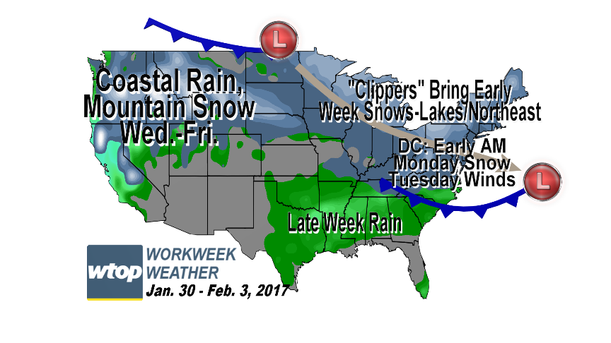
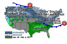
The last two days of January will feature two "Alberta Clippers" moving through the area. The first will have almost finished what it's doing by Monday morning. The other will move through Tuesday, but its path will likely mean most, if not all, of its rain or snow will be in Ohio, Pennsylvania and New England.
The last two days of January will feature two “Alberta Clippers” moving through the area.
(WTOP/Storm Team 4)
WTOP/Storm Team 4
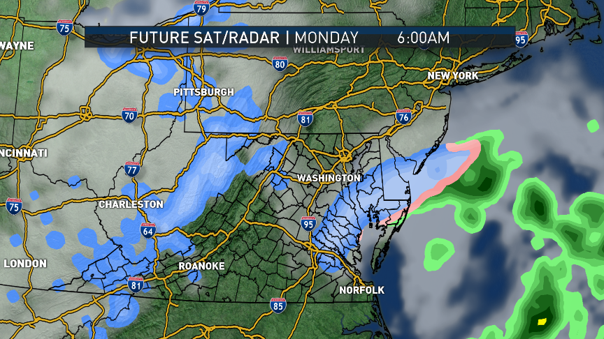
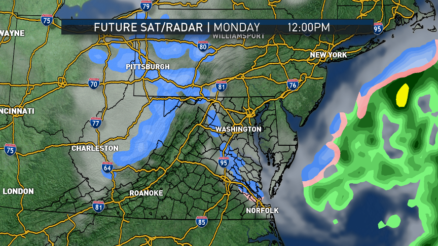
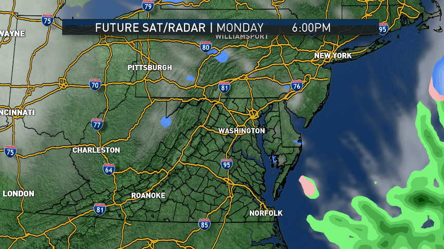
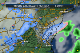
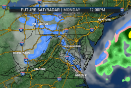
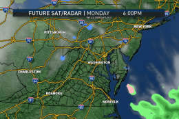
The computer model output shows the two distinct systems for Monday and Tuesday.
(Data: RPM model, The Weather Company. Graphics: Storm Team 4)
Data: RPM model, The Weather Company. Graphics: Storm Team 4
The graphics are a simulation of precipitation type radar and clouds. Note Monday’s system is already scooting east in the morning, clouds are clearing around midday, and we are totally dry and mostly clear for the evening.
(Data: RPM model, The Weather Company. Graphics: Storm Team 4)
Data: RPM model, The Weather Company. Graphics: Storm Team 4
Note Monday’s system is already scooting east in the morning, clouds are clearing around midday, and we are totally dry and mostly clear for the evening.
(Data: RPM model, The Weather Company. Graphics: Storm Team 4)
Data: RPM model, The Weather Company. Graphics: Storm Team 4
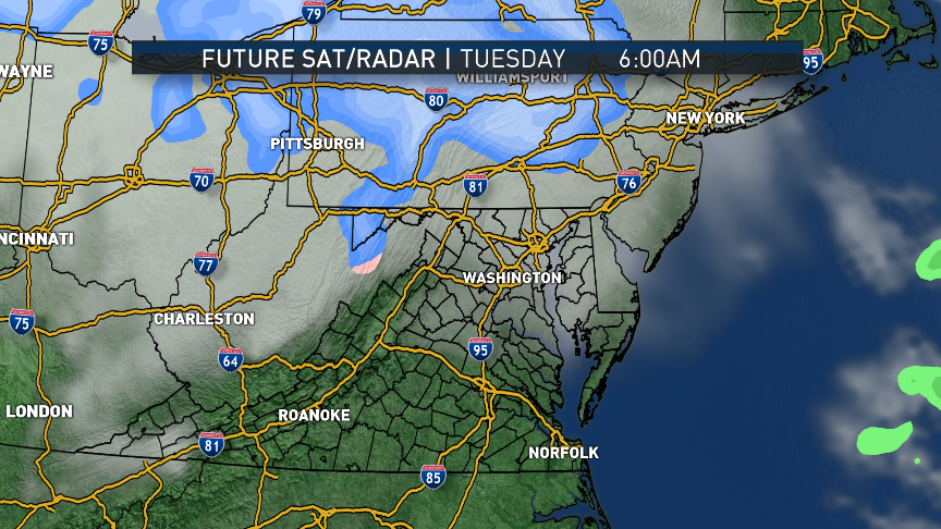
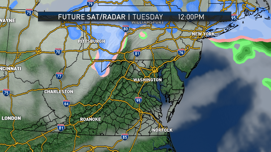
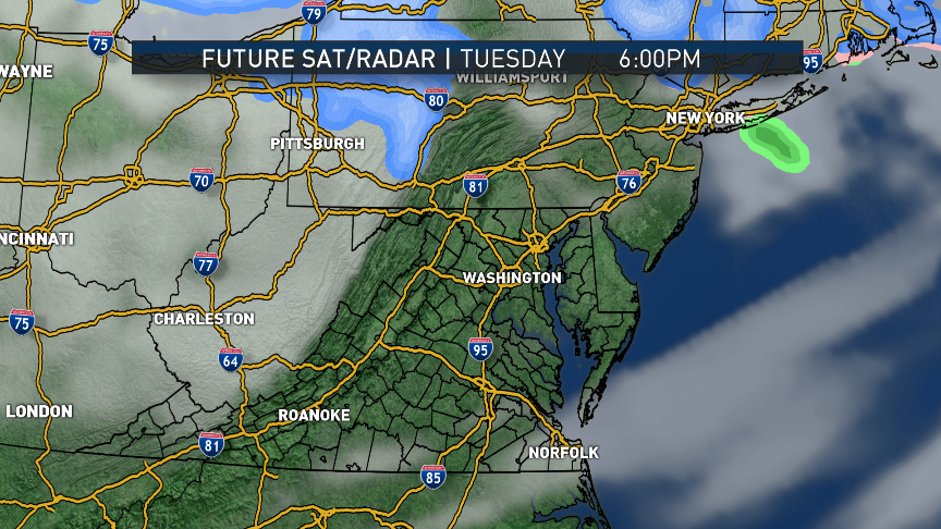
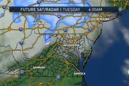
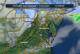
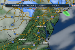
Tuesday’s system is encroaching from the north already on Tuesday, but the precipitation looks like it won’t quite make it this far south.
(Data: RPM model, The Weather Company. Graphics: Storm Team 4)
Data: RPM model, The Weather Company. Graphics: Storm Team 4
This isn’t always the case, though, so it bears some watching through Tuesday.
(Data: RPM model, The Weather Company. Graphics: Storm Team 4)
Data: RPM model, The Weather Company. Graphics: Storm Team 4
This isn’t always the case, though, so it bears some watching through Tuesday.
(Data: RPM model, The Weather Company. Graphics: Storm Team 4)
Data: RPM model, The Weather Company. Graphics: Storm Team 4
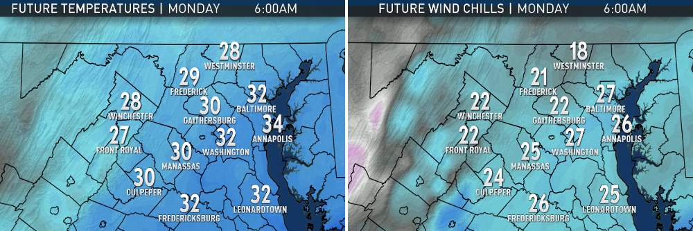
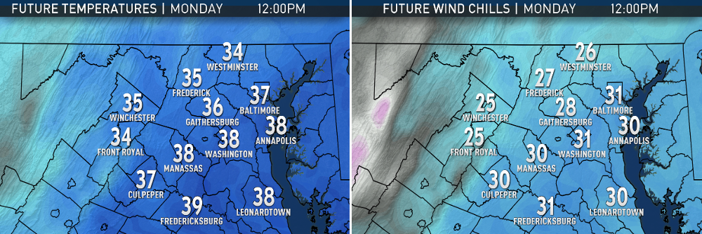
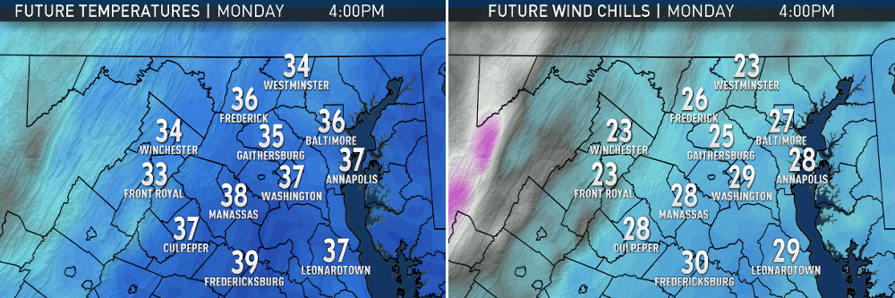
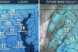
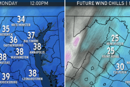
From the same computer model, compare the actual temperatures with the temperature downward adjustment due to the wind (a.k.a. the wind chills).
(Data: RPM model, The Weather Company. Graphics: Storm Team 4)
Data: RPM model, The Weather Company. Graphics: Storm Team 4
Temperatures will start out near freezing as the snow is wrapping up.
(Data: RPM model, The Weather Company. Graphics: Storm Team 4)
Data: RPM model, The Weather Company. Graphics: Storm Team 4
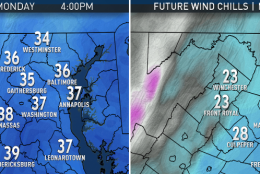
Temperatures will climb above freezing again in the afternoon into the evening rush, but all day it will be much colder due to the wind.
(Data: RPM model, The Weather Company. Graphics: Storm Team 4)
Data: RPM model, The Weather Company. Graphics: Storm Team 4
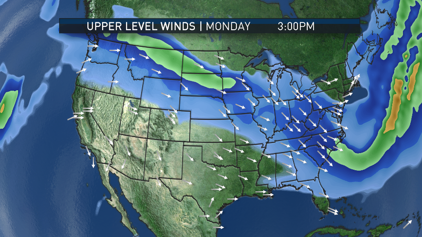
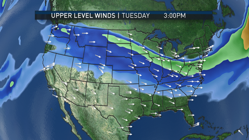
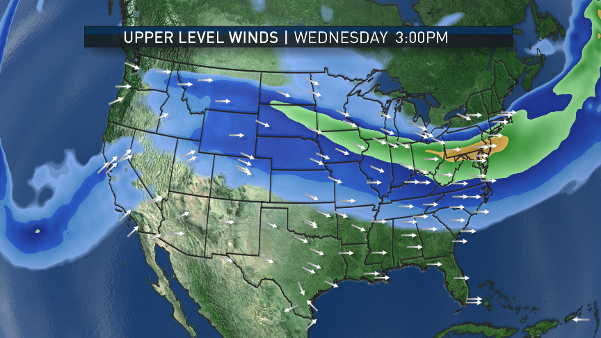
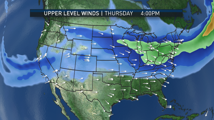
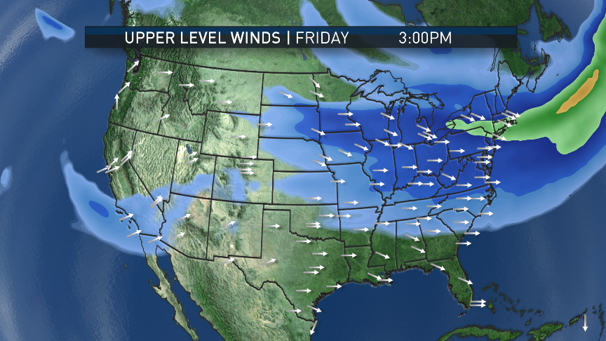
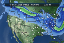
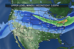
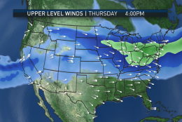
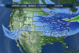
The following images are for the winds aloft during the afternoons this week, based on the American GFS computer model. The jet stream configuration can be examined to describe the overall weather pattern over North America. In the beginning of the week, there is a trough (or dip) in the east, allowing some of the colder air from Canada (though definitely not quite Arctic), and it also helps steer the two systems through. (Data: GFS model: Environmental Modeling Center, NOAA. Graphics: Storm Team 4)
(Storm Team 4)
Storm Team 4
Note that the jet stream appears to be coming out of the region of Alberta, Canada, and that’s where the systems get their name. But clippers moving like this don’t have much moisture to work with. (Data: GFS model: Environmental Modeling Center, NOAA. Graphics: Storm Team 4)
(Storm Team 4)
Storm Team 4
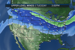
Also, when the pattern flattens out for the rest of the week, it won’t be that cold and there also won’t be any big precipitation makers. (Data: GFS model: Environmental Modeling Center, NOAA. Graphics: Storm Team 4)
(Storm Team 4)
Storm Team 4
In the graphic, the strongest winds are the brighter colors in the middle of the streaks. (Data: GFS model: Environmental Modeling Center, NOAA. Graphics: Storm Team 4)
(Storm Team 4)
Storm Team 4
As an aside, with the speeds themselves lessening toward the end of the week, some flights to the West Coast may make some better than usual time. (Data: GFS model: Environmental Modeling Center, NOAA. Graphics: Storm Team 4)
(Storm Team 4)
Storm Team 4
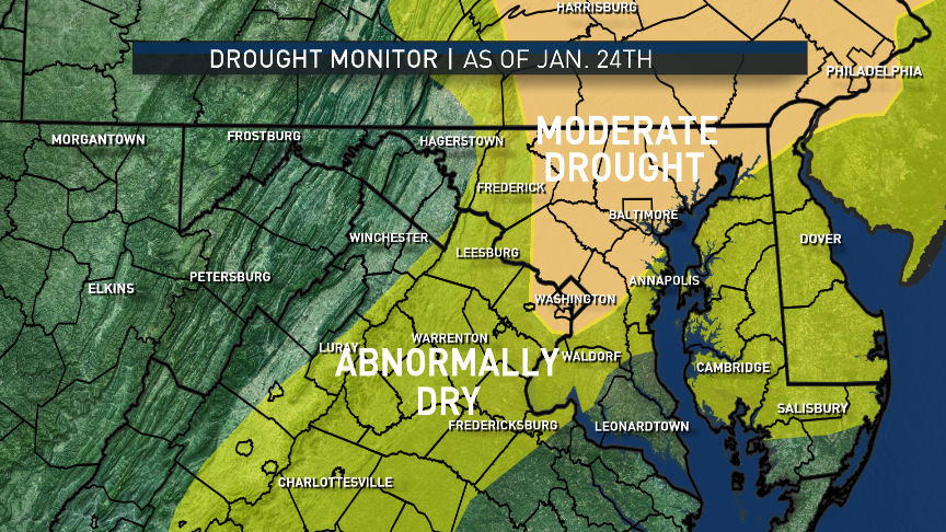
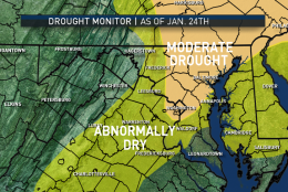
Lastly, there’s been some improvement in the local drought situation for many of us, especially in Virginia, thanks to January’s wet weather. A lot of the areas considered to be in “Moderate Drought” have been scaled back but they persist in a lot of Maryland up toward the Delaware Valley. A lot of Northern Virginia is now just considered “Abnormally Dry,” and many spots along the Blue Ridge are no longer even on the scale.
(Data: The National Drought Mitigation Center. Graphics: Storm Team 4)
Data: The National Drought Mitigation Center. Graphics: Storm Team 4
WASHINGTON — The last two days of January will feature two “Alberta Clippers” moving through the area.
The first will have already almost finished what it’s going to do by the time the Monday morning rush starts. A widespread coating to an inch of wet snow should slow the rush hour down, but there’s a likelihood a lot of the main highways will just be wet because of the ground temperatures and the road treatments. At any rate, the system is history by lunchtime and we’ll just be left with a cold, blustery day.
In the fast, northwesterly flow, another Clipper system will move through on Tuesday, but its path will likely mean most, if not all, of its rain or snow will be in Ohio, Pennsylvania and New England. In fact, temperatures will likely be quite mild ahead of the system’s center, courtesy of at least partial sunshine and southwesterly winds at the surface sloping down the Appalachians. That system will bring in some slightly cooler, more seasonable weather for Wednesday, the first day of February.
After that, the pattern across the United States will relax a bit, losing the coldest air back into Canada, and our flow will be from across the continent from west to east. In any event this week, there is no good moisture source, so no system will be able to produce a lot of precipitation.
The second half of the week will have average to slightly below average temperatures.
Daily weather highlights
MONDAY
• Almost all accumulating snow over with by/during morning rush
• Winds picking up; blustery and cold all day
• Clouds start breaking up west to east during the midday hours
• Lots of snowmelt and drying out during the afternoon
TUESDAY
• Sunshine with increasing clouds
• Windy but much milder
• Likely dry all day but precipitation north will have to be watched to see if some makes it over the mountains
WEDNESDAY
• Mix of sun and clouds
• Brisk and chilly, but seasonable
THURSDAY
• Mostly sunny skies
• Seasonably cool; less wind
FRIDAY
• Partly sunny to mostly cloudy
• Seasonably cool
Editor’s Note: The WTOP Workweek Weather Blog is intended as an in-depth yet plain language summary of the business week’s weather potential in the D.C. area along with an explanation of the contingencies and uncertainties that exist at the time of publication. For the latest actual Storm Team 4 forecast, check out the main WTOP Weather Page.