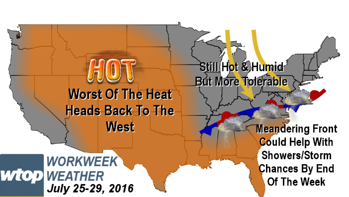
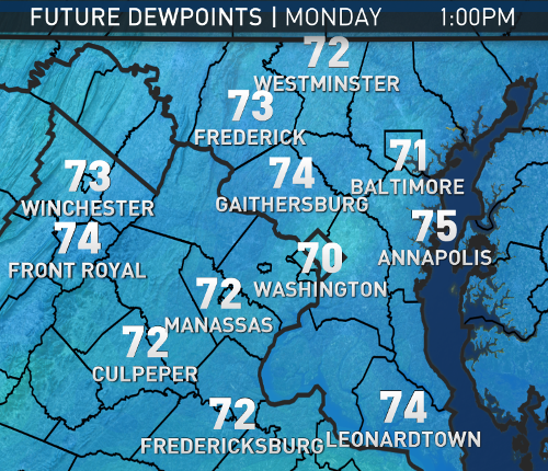
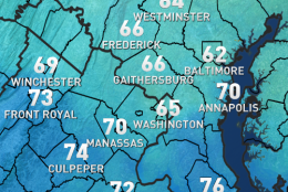
WASHINGTON — The heat wave that started last week will continue, possibly through the whole week. By Monday morning’s rush hour, the humidity will have already climbed back up to much muggier levels than what we had Saturday.
Record highs have a much better chance of being tied or broken Monday than they did over the weekend. A “heat advisory” will be in effect Monday for the entire area from noon until 8 p.m. as the combination of actual high temperatures and high humidity will have the heat index close to 105, if not 110. Everyone should be prepared to deal with the heat — especially the elderly and the very young — and anyone who has to work outside for a long period of time will need to also take precautions.
The daytime heating of all the humidity will allow some scattered thunderstorms to form Monday afternoon and evening, but not all of us will see them. Any storms that do form could have some tropical-like downpours.
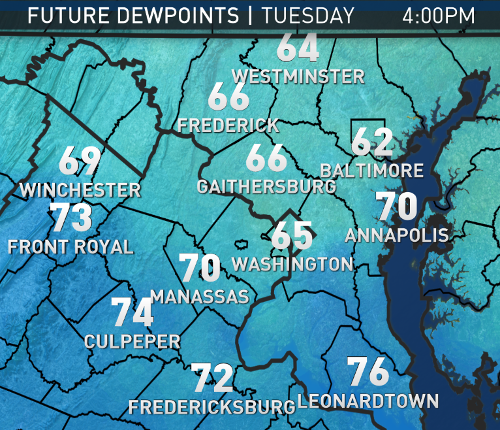
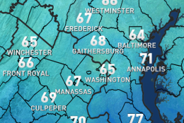
Between Tuesday and Wednesday, a slow-moving, weak cold front will approach from the north. At this point, it’s unclear how fast the front will be able to make it through and that will have implications on how much the humidity will drop, and also whether Tuesday or Wednesday will have the best chance for thunderstorms.
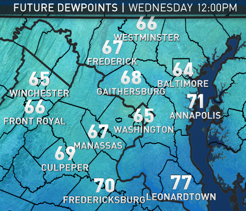
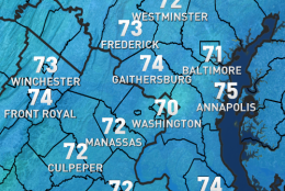
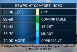
Either way, northern Maryland will be the first area to see the humidity drop from tropical, oppressive levels to just typically-feeling-sticky levels. The relatively drier air will eventually make it to D.C. after the middle of the week, behind the boundary. Temperatures will get knocked down from the high 90s to lower 90s. So perhaps our relief will be modest at best and the heat wave will continue.
As the core of the ridge of high pressure that’s causing the heat wave retrogrades to the Plains and the Rockies, low pressure will dip down from Canada and set up shop in the Great Lakes, trapping the old front along the Appalachians, and several disturbances will cause clusters of showers and thunderstorms. It is unclear at this point if most of those storms will stay in the Ohio Valley and New England — where they really need the rain — or if we will get some of the storm action. If we do end up getting enough showers and cloud cover, we could break the heat wave by the end of the workweek.
Daily weather highlights:
MONDAY
• Very hot and very humid again
• Hottest day of the week, both in terms of actual high temperature and heat index
• Heat index between 105 and 110
• Late afternoon hit-or-miss thunderstorms
TUESDAY
• Still very humid, especially the first half of the day
• High temperatures may “only” make it into the mid 90s
• Late afternoon scattered thunderstorms
• Humidity starts dropping a bit north of D.C.
WEDNESDAY
• Lingering, early thunderstorms still possible
• Still hot with high temperatures in the mid 90s
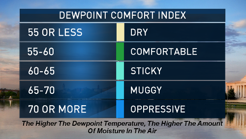
• Humidity drops for most to the “sticky” levels from the oppressive levels
THURSDAY
• More sun than clouds; heating up again
• Humidity stays on the lower end of uncomfortable
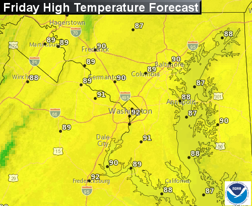
FRIDAY
• Increasing clouds
• Good chance of showers and thunderstorms
• Temperatures may not get above 90 if there is enough cloud cover
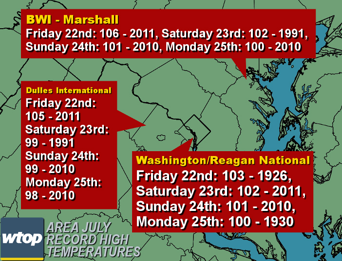
On Sunday all the major regional airports officially stayed again just below 100 degrees, even though the humidity made it feel like we reached 100. There’s a more likely chance we will reach 100 on Monday, which would be a record tied high temperature for Washington.
Here’s a summary of the high temperatures since last Friday. Notice also that all the high temperatures stayed below records.
FRIDAY, JULY 22nd
DCA 95
IAD 94
BWI 94
SATURDAY, JULY 23rd
DCA 98
IAD 98
BWI 98
SUNDAY JULY 24th
DCA 97
IAD 97
BWI 94
On Sunday all the major regional airports officially stayed again just below 100 degrees, even though the humidity made it feel like we reached 100. There’s a more likely chance we will reach 100 on Monday, which would be a record tied high temperature for Washington.
Here’s a summary of the high temperatures since last Friday. Notice also that all the high temperatures stayed below records.
FRIDAY July 22nd
DCA 95
IAD 94
BWI 94
SATURDAY July 23rd
DCA 98
IAD 98
BWI 98
SUNDAY July 24th
DCA 97
IAD 97
BWI 94
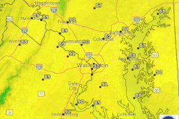
This graphic shows the records which still stand, and the records which are in jeopardy on Monday.
Editor’s Note: The WTOP Workweek Weather Blog is intended as an in-depth yet plain language summary of the business week’s weather potential in the D.C. area along with an explanation of the contingencies and uncertainties that exist at the time of publication. For the latest actual Storm Team 4 forecast, check out the main WTOP Weather Page.