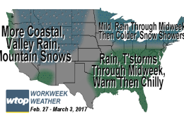
This week's warm spell won't be several days long this time. A vigorous cold front will quickly swing through on Wednesday, causing enough lift in the atmosphere for more showers and possible thunderstorms, some of which could again become quite gusty with hail.
This warm spell won’t be several days long this time. A vigorous cold front will quickly swing through on Wednesday, causing enough lift in the atmosphere for more showers and possible thunderstorms, some of which could again becoming quite gusty with hail.
(WTOP/Storm Team 4)
WTOP/Storm Team 4
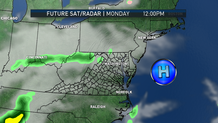
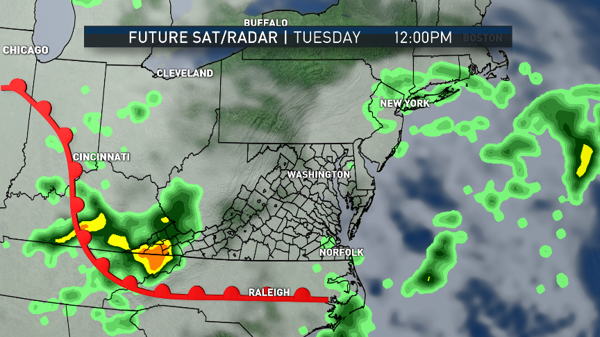
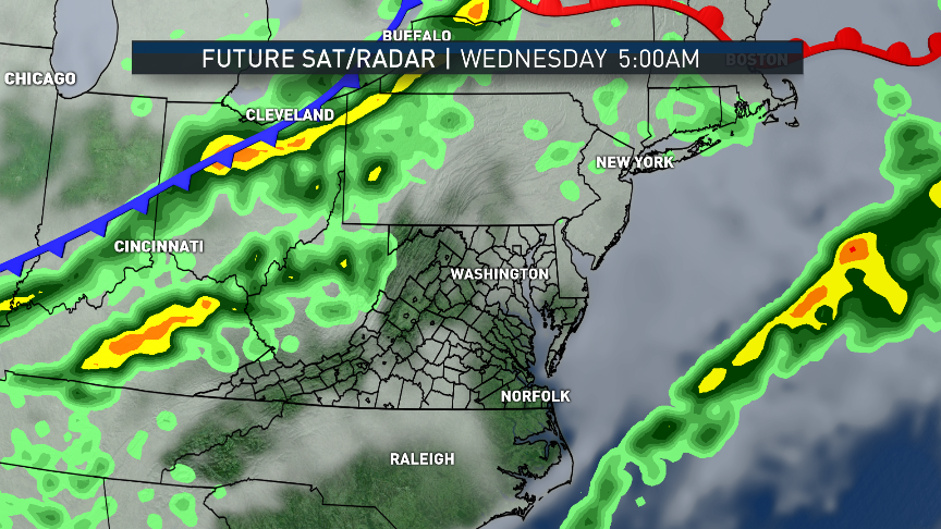
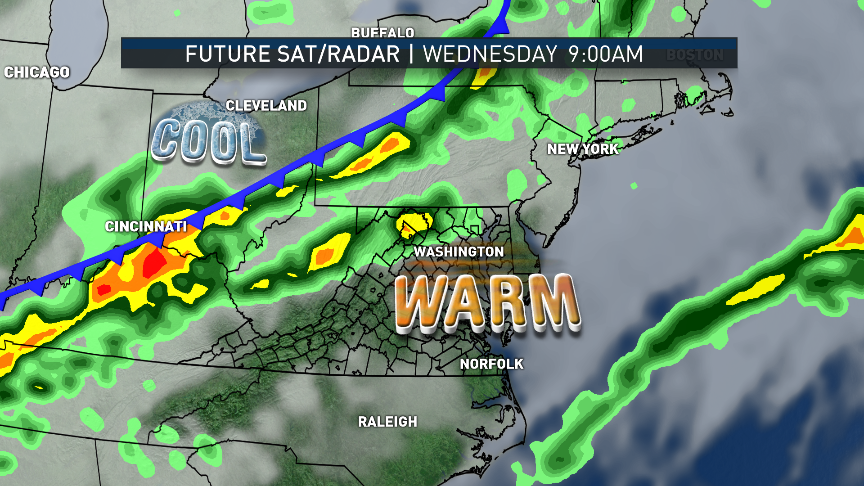
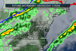
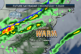
These images are from the RPM computer model through midweek and show the advance of the warm front and the eventual cold front. High pressure will be moving offshore and a few batches of light precipitation will accompany the warm front late Monday through late Tuesday. On Wednesday, it will be a line of showers and likely thunderstorms.
(Data: The Weather Company; Graphics: Storm Team 4)
Data: The Weather Company; Graphics: Storm Team 4
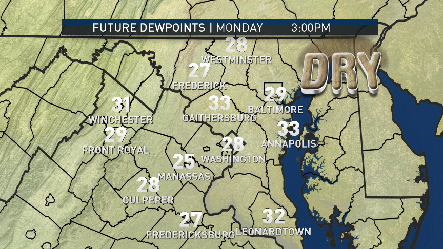
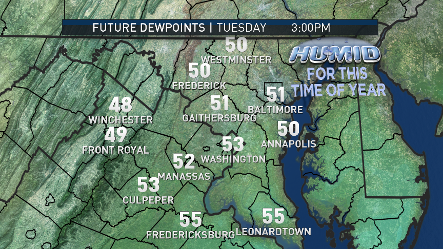
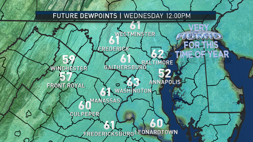
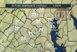
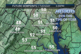
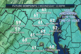
While this is happening, you can see the transition from dry air to humid air via the dew point forecast from the RPM, also. Remember as in the warm months, the higher the dew point, the more moisture there is in the air, period. We just don’t usually have to talk about it in the cold months because the changes don’t usually contribute to it feeling muggy. This week, they will: 60s would feel sticky in summer.
(Data: The Weather Company; Graphics: Storm Team 4)
Data: The Weather Company; Graphics: Storm Team 4
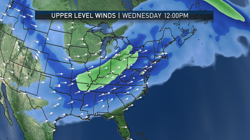
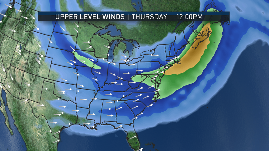
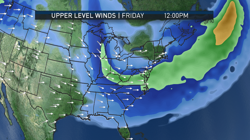
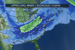
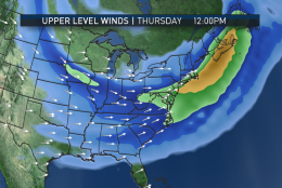
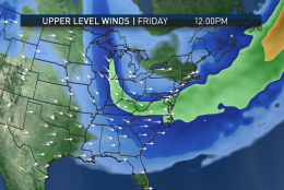
By the middle of the week, the warm front will be pushed through by a ridge in the jet stream and we will have southwesterly flow starting near the Gulf of Mexico at the surface and aloft. The GFS computer model simulation of the jet stream breaking down into a trough (or dip) in the East will be occurring with the cold front and storms on Wednesday. The core of the jet will be passing over us and will contribute to the threat of gusty winds. Friday’s weak cold front will be riding the jet from Canada.
(Data: Environmental Modeling Center, NOAA; Graphics: Storm Team 4)
Data: Environmental Modeling Center, NOAA; Graphics: Storm Team 4
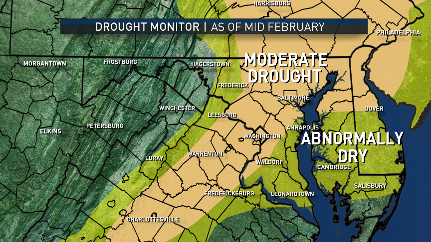
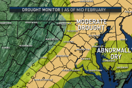
Again, most of the area is back to being designated as in “Moderate Drought,” with groundwater and waterway effects but mostly very dry brush and topsoil concerns. In case you missed it, Storm Team 4 Meteorologist Lauryn Ricketts recently wrote a blog summary of the warm and dry winter. (Data: Drought Monitor, U.S. Drought Mitigation Center; Graphics: Storm Team 4)
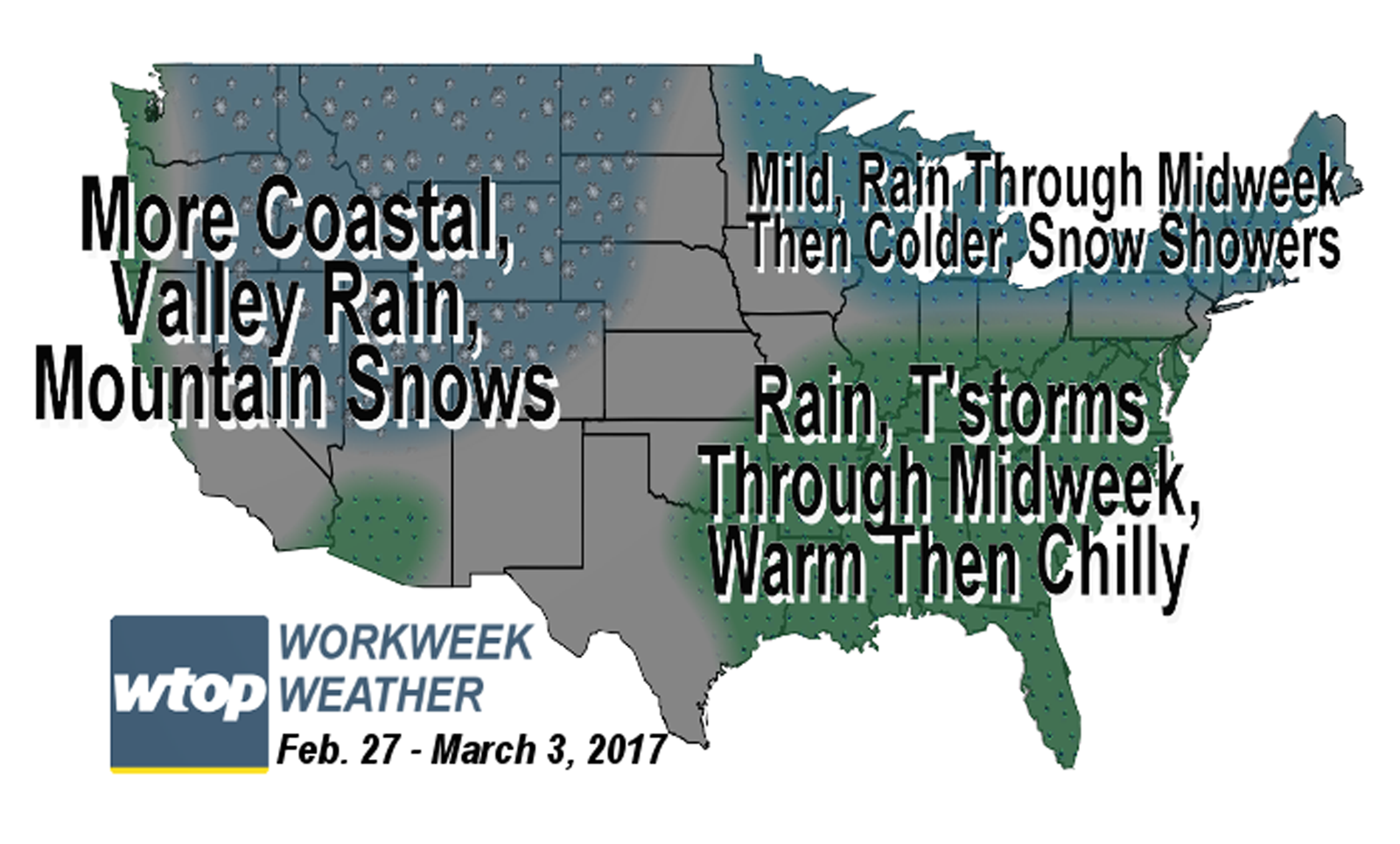
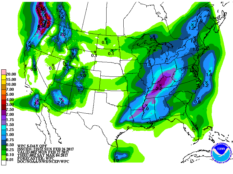
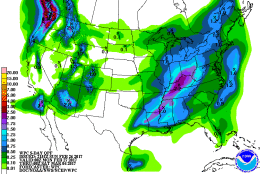
This week, the West will see more wet and wintry weather, but perhaps not as much in as many locations. The overall pattern over the Pacific and North America will change little. In the East, the heaviest soaking rains will likely miss us just to our west, but we’ll likely see several tenths to half an inch, possibly more, in thunderstorms on Wednesday. This graphic is for the period early Monday morning through Friday afternoon.
(Weather Prediction Center, NOAA)
WASHINGTON — High pressure responsible for the cold transport of air on Sunday — “cold” being a relative term — is also responsible for the mainly clear skies from Sunday night and the freezing start to Monday in many locations.
Like so many this season, this high pressure system will be heading out to sea to form another “Bermuda High” and pump in more warmth while the coldest air in the country dives into the Rockies and the Plains. A warm front aloft will already be increasing cloud cover early Monday morning and that will continue throughout the day. Although the front at the surface will not be through our area yet, temperatures will already be milder than they were on Sunday. A small band of showers will have to be watched along the front aloft, but the most likely areas they will move will be just to our north and west, but some of them will get closer to us Monday night.
Temperatures won’t drop much Monday night as the front at the surface gets even closer and because of the cloud cover. A lot more moisture will be tapped from the Gulf of Mexico this time around, and some people will notice the humidity increasing Tuesday with the chance for showers and drizzle increasing.
By Wednesday, the first day of March, the front will be to our north and the Gulf of Mexico will be “wide open,” as meteorologists describe it, giving the day a very balmy feel — that is, warm and humid by this time of year standards. Temperatures will be close to record highs and dew points will be in the upper 50s, which would count as a relatively comfortable day in the middle of summer, but muggy in winter.
This warm spell won’t be several days long this time. A vigorous cold front will quickly swing through on Wednesday, causing enough lift in the atmosphere for more showers and possible thunderstorms, some of which could again becoming quite gusty with hail. The jet stream winds will be transforming into a trough of low pressure in eastern Canada and the U.S., allowing colder air to persist for the rest of the workweek — “colder” again being a relative term. Temperatures will be maxing out near or just below our averages for Thursday and Friday. Within the colder northwesterly flow, a quick moving system like an Alberta clipper will bring some scattered light rain showers Friday, possibly mixed in with some wet snowflakes in the higher elevations.
The rains for midweek will be welcome and beneficial, but not excessive. As warm as this winter has been, it has also been dry. Drought conditions have expanded again as has the risk for brush fires, as per the Drought Information Center.
Daily Weather Highlights
MONDAY
• Cold start
• Clouding over in the morning and staying that way; only peeks of sun
• A few showers or some drizzle toward evening, mostly northwest suburbs
• Temperatures slightly above average
TUESDAY
• More clouds than sun
• Feeling like spring again
• Starting to feel a bit humid
WEDNESDAY
• Clouds and a bit of fog early, then partly sunny
• Breezy and unseasonably warm and unseasonably muggy
• Close to record highs (80 degrees in 1976 for Reagan National Airport)
• Clouds may inhibit max heating
• Showers and thunderstorms arriving, strength depending on how warm and muggy
THURSDAY
• Windy and much cooler and less humid
• Temperatures closer to average
FRIDAY
• Breezy and the chilliest day of the week
• Temperatures slightly below average
• A chance of scattered showers
Editor’s Note: The WTOP Workweek Weather Blog is intended as an in-depth yet plain language summary of the business week’s weather potential in the D.C. area along with an explanation of the contingencies and uncertainties that exist at the time of publication. For the latest actual Storm Team 4 forecast, check out the main WTOP Weather Page.