Storm Team 4 meteorologist Matt Ritter says it will take some time before it gets as cold as last week. Weather really shouldn’t interfere with anyone who’s been putting off finishing his holiday shopping this week.
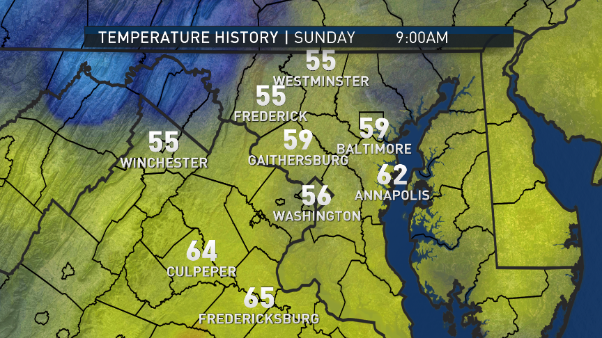
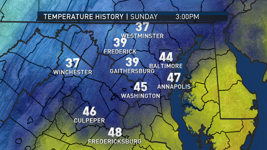
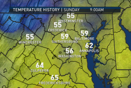
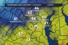
Here’s how temperatures changed across the listening area on Sunday as the Arctic front plowed through.
(Courtesy Storm Team4)
Courtesy Storm Team4
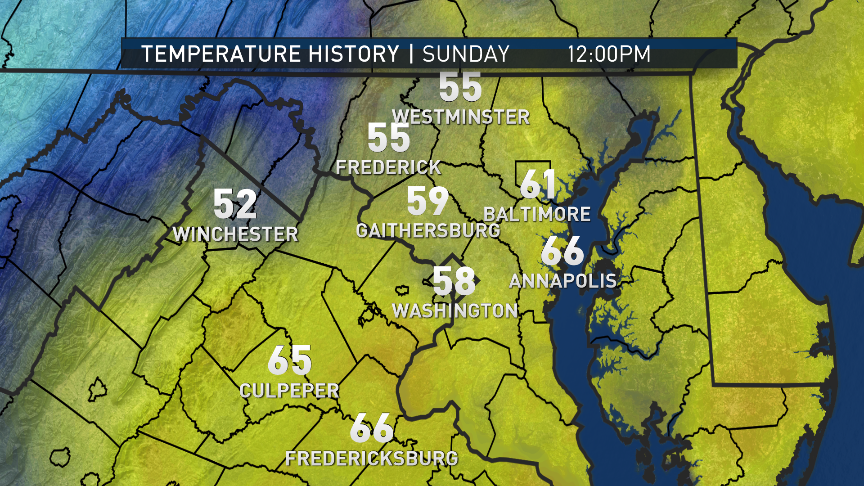
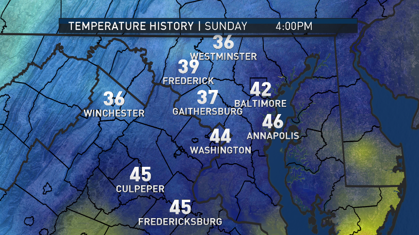
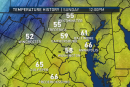
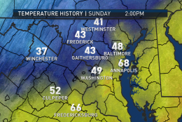
Here’s how temperatures changed across the listening area on Sunday as the Arctic front plowed through.
(Courtesy Storm Team4)
Courtesy Storm Team4
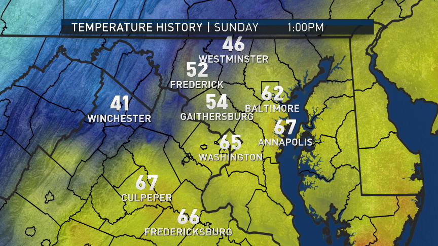
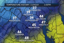
Here’s how temperatures changed across the listening area on Sunday as the Arctic front plowed through.
(Courtesy Storm Team4)
Courtesy Storm Team4
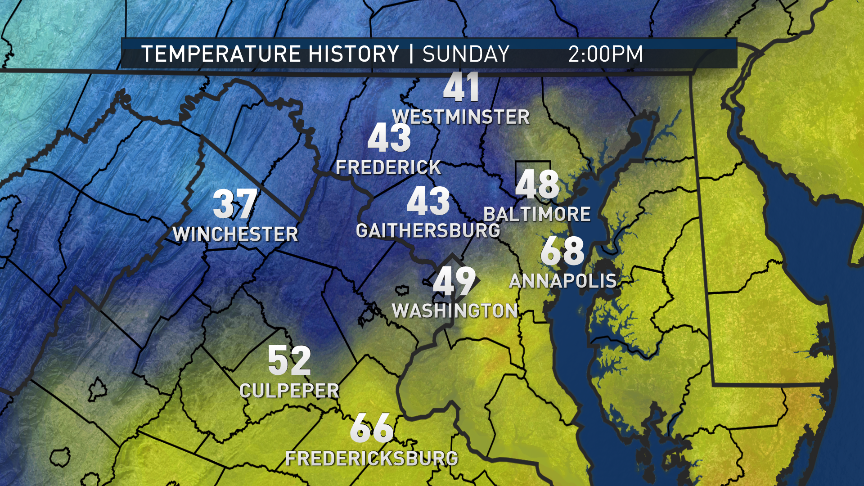
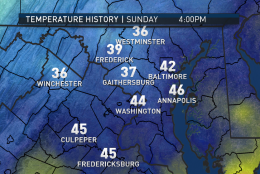
Here’s how temperatures changed across the listening area on Sunday as the Arctic front plowed through.
(Courtesy Storm Team4)
Courtesy Storm Team4
Here’s how temperatures changed across the listening area on Sunday as the Arctic front plowed through.
(Courtesy Storm Team4)
Courtesy Storm Team4
Here’s how temperatures changed across the listening area on Sunday as the Arctic front plowed through.
(Courtesy Storm Team4)
Courtesy Storm Team4
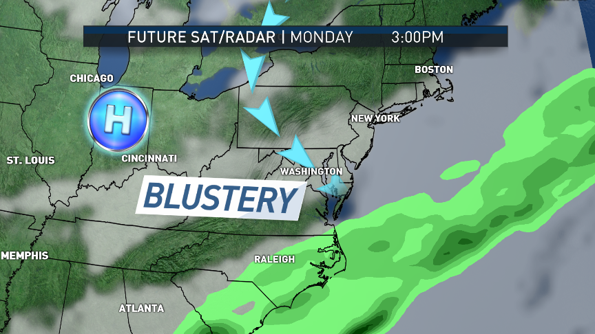
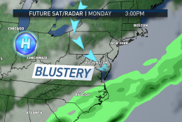
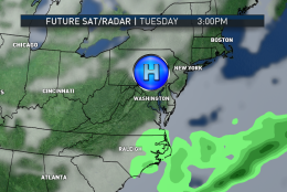
As for the beginning of the new week, high pressure builds in from the middle of the country, keeping us dry and cold at the start. The model generating the future clouds and future radar is the North American Mesoscale model .
(Courtesy Environmental Modeling Center/NOAA. Graphics: Storm Team4)
As for the beginning of the new week, high pressure builds in from the middle of the country, keeping us dry and cold at the start.The model generating the future clouds and future radar is the North American Mesoscale model (NAM).
(Data: Environmental Modeling Center/NOAA. Courtesy Storm Team4)
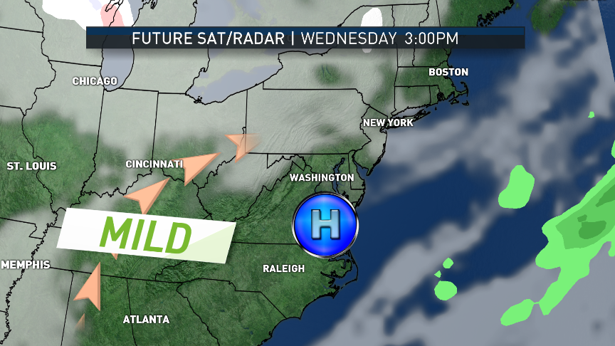
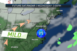
Westerly flow will moderate temperatures by Wednesday. The clouds from the next system that will affect us already building from the north. The model generating the future clouds and future radar is the North American Mesoscale model (NAM).
(Data: Environmental Modeling Center/NOAA. Courtesy Storm Team4)
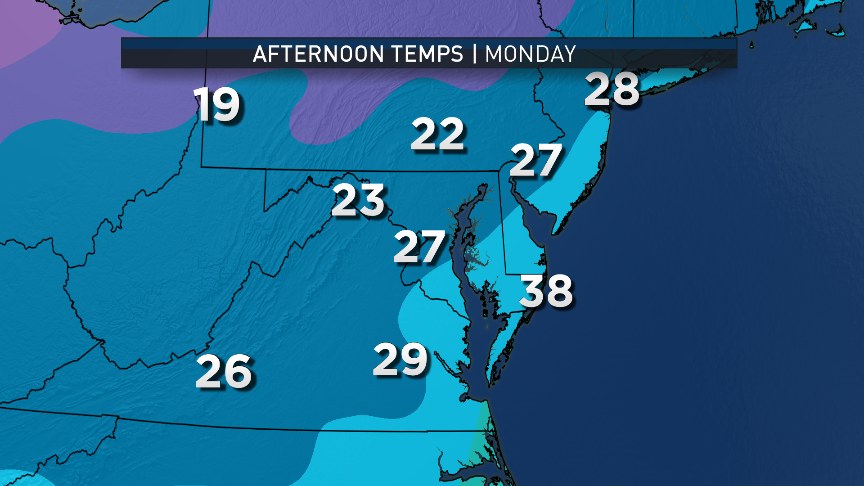
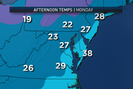
No big temperature swings are expected this week. The GFS model images show temperatures starting off cold, then creeping back up to the averages for this time of the year. The blustery winds on Monday especially will make it feel colder. Temperatures will peak in the 30s early, then fall into the 20s.
(Data: Environmental Modeling Center, NOAA. Courtesy Storm Team4)
Data: Environmental Modeling Center, NOAA. Courtesy Storm Team4
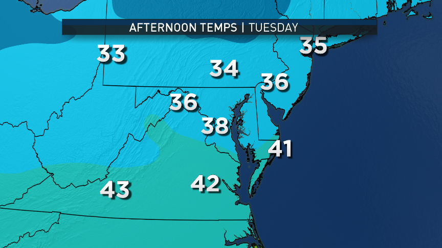
No big temperature swings are expected this week. The GFS model images show temperatures starting off cold, then creeping back up to the averages for this time of the year.
(Data: Environmental Modeling Center, NOAA. Courtesy Storm Team4)
Data: Environmental Modeling Center, NOAA. Courtesy Storm Team4
No big temperature swings are expected this week. The GFS model images show temperatures starting off cold, then creeping back up to the averages for this time of the year.
(Data: Environmental Modeling Center, NOAA. Graphics: Storm Team4)
Data: Environmental Modeling Center, NOAA. Graphics: Storm Team4
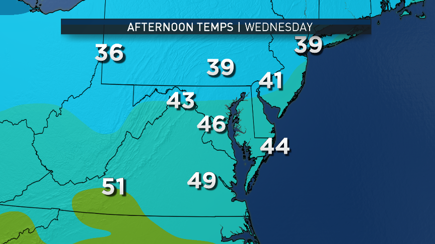
WASHINGTON — The new workweek starts with the latest Arctic air mass spilling over the mountains courtesy of the front, which blasted its way through the area Sunday afternoon.
This blast of Arctic air was, of course, right on the heels of the one from the end of last week. But this time, it looks like it will take some time before we get this cold again.
A blustery northwest wind will continue all day on Monday, with temperatures struggling to get much higher than the morning lows. Winds will be gusty until about mid-afternoon, and then the winds will start to subside.
Most of the day will have a lot of threatening-looking skies, with low level clouds and peeks of sunshine. A lot of that cloud cover will break up during the evening hours. Prepare to bundle up for the Panthers/Redskins game Monday evening. Temperatures will be falling into the 20s again by game time; it won’t be as windy, but just enough of a breeze will make it feel like it’s in the teens.
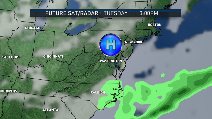
The center of the Arctic high pressure system that pushed the cold front through will be moving closer to us on Tuesday, moving in almost directly overhead. This will mean much more sunshine, but considering it will be the last full day of fall, the sun angle won’t be able to do much. After a very cold start, highs will only make it to levels 5–10 degrees below average. There will be another very cold night and start to Wednesday.
Speaking of the start of Wednesday, the winter solstice will officially occur at 5:44 a.m. Eastern Standard Time. The sun will be at its lowest point in the sky for the Northern Hemisphere, and directly over the Tropic of Capricorn in the Southern Hemisphere. But here, as high pressure begins to move away, the trend will be toward milder weather, all the way through this upcoming holiday weekend.
There’s a chance for some wet weather on Thursday with a weak cold front and some moisture being drawn north from the Gulf of Mexico. Right now it looks like there’s a chance for some light rain and drizzle developing during the day. Some computer model solutions are much drier and barely give the region any rain, and some model solutions not only give the area more rain, they keep it wetter through Friday morning. So there’s a lot of uncertainty about Thursday with the subtle pattern shift.
Regardless, the Arctic air supply is not as plentiful for now after the three Arctic blasts earlier this month. The supply is basically exhausted until it can “recharge,” so to speak. The very cold temperatures will likely return in January at some point.
Weather really shouldn’t interfere with anyone who’s been putting off finishing his holiday shopping this week.
Daily weather highlights
MONDAY
•Windy, blustery, and cold
•Peeks of sun through mostly cloudy skies
•Less wind for Redskins game, but temperatures in the 20s
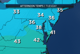
TUESDAY •Much more sunshine than cloud cover
•Not as windy
•Temperatures still below average and quite chilly
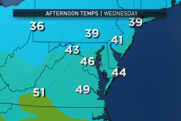
WEDNESDAY •Winter arrives at 5:44 a.m. and it will be wintry cold
•Sunshine with high level clouds moving overhead
•More seasonable temperatures in the upper 40s
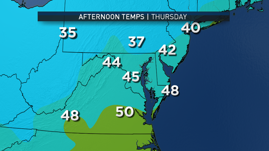
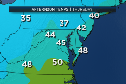
THURSDAY •Mostly cloudy skies keep it chillier
•A chance for light rain and drizzle by the end of the day
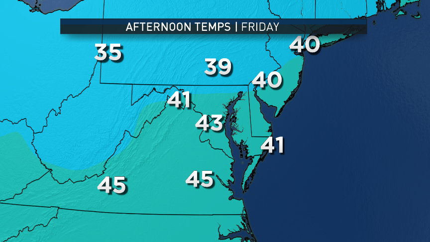
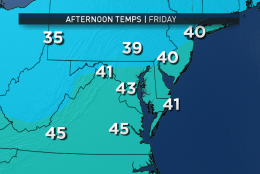
FRIDAY •Chance for light rain and drizzle lingering into the morning
•Otherwise, skies likely clearing by evening
•Seasonable temperatures in the upper 40s
NOTE: The WTOP Workweek Weather Blog is intended as an in-depth yet plain-language summary of the business week’s weather potential in the D.C. area, along with an explanation of the contingencies and uncertainties that exist at the time of publication. For the latest actual Storm Team 4 Forecast, check out the Main WTOP Weather Page.