The greater WTOP listening area will have several chances for some needed rainfall.
The greater WTOP listening area will have several chances for some needed rainfall.
(WTOP/Storm Team 4)
WTOP/Storm Team 4
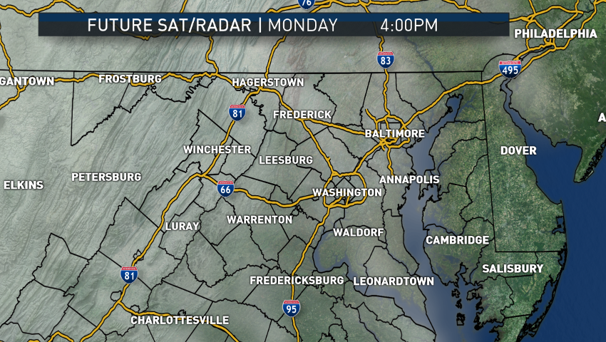
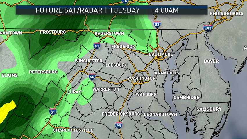
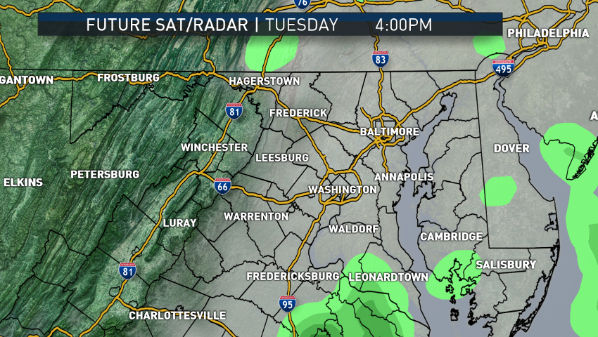
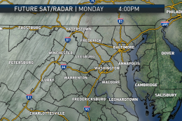
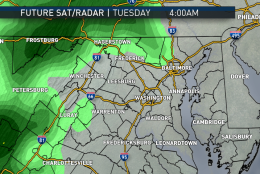
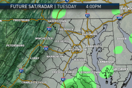
These images are computer model outputs for future clouds and radar from The Weather Company’s RPM model, which ran Sunday afternoon.
(Data: The Weather Company/Graphics: Storm Team 4)
Data: The Weather Company/Graphics: Storm Team 4
These images show us clouding over Monday with bands of rain arriving Monday night and into the Tuesday morning rush, then ending Tuesday afternoon.
(Data: The Weather Company/Graphics: Storm Team 4)
Data: The Weather Company/Graphics: Storm Team 4
All the other available longer range computer models have the second swath of rain moving in Wednesday night and Thursday.
(Data: The Weather Company/Graphics: Storm Team 4)
Data: The Weather Company/Graphics: Storm Team 4
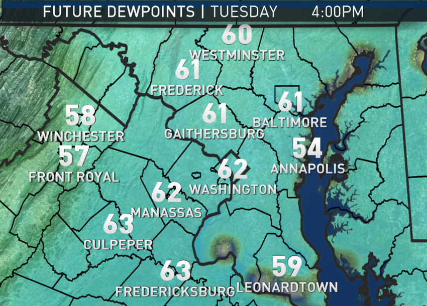
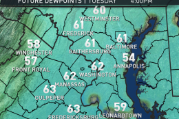
Also from the RPM model, the dew point potential by Tuesday afternoon. We’re going from bone-dry to humid, even by summer standards. The higher the dew point, the higher the amount of moisture in the area. Dew points in the 60s would make most people feel uncomfortable in the summer, much less late fall.
(Data: The Weather Company/Graphics: Storm Team 4)
Data: The Weather Company/Graphics: Storm Team 4
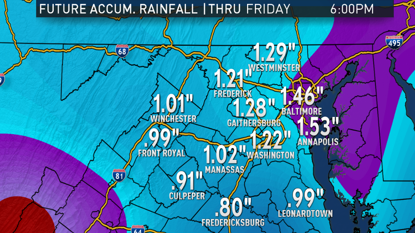
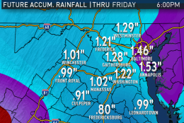
The American GFS computer model that ran Sunday morning shows its rainfall accumulation potential through Friday evening. This is the model’s total for both storms. Numbers are unlikely to be less than this, but there is potential for it to be more. Even if this computer ends up being correct, it’s still going to be beneficial rainfall and the best chances for it in quite some time.
(Data: Environmental Modeling Center, NOAA/Graphics: Storm Team 4)
Data: Environmental Modeling Center, NOAA/Graphics: Storm Team 4
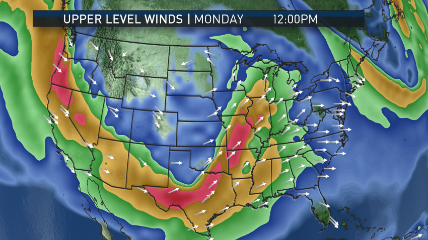
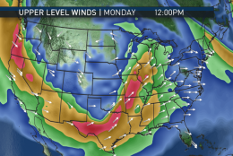
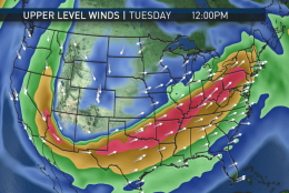
These next images are also from the GFS computer, which ran from Sunday morning.
(Data: Environmental Modeling Center, NOAA/Graphics: Storm Team 4)
Data: Environmental Modeling Center, NOAA/Graphics: Storm Team 4
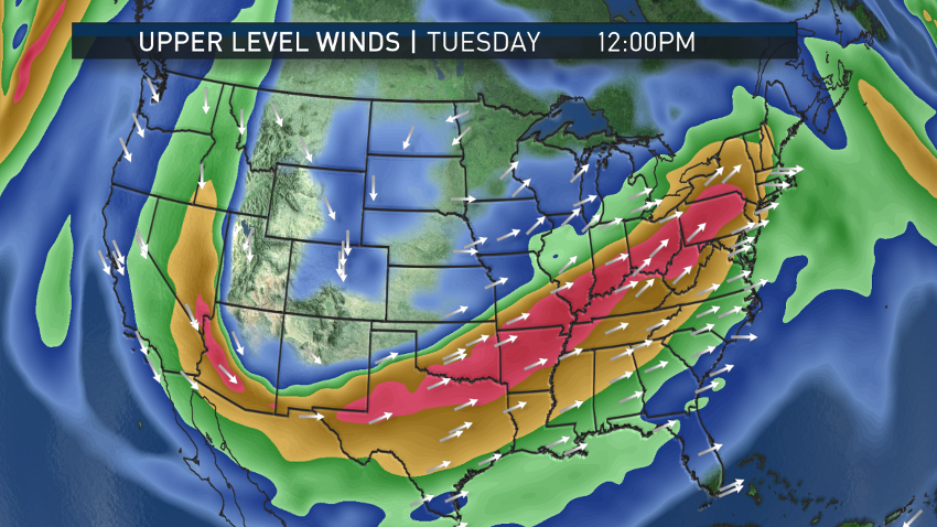
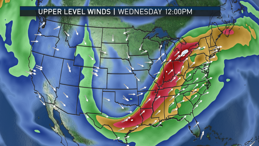
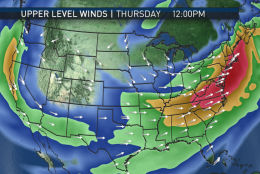
It shows the progression of the jet stream with time, the “trough” digging into the south then coming up the mountains, bringing us the waves of low pressure at the surface and our wet, warm weather.
(Data: Environmental Modeling Center, NOAA/Graphics: Storm Team 4)
Data: Environmental Modeling Center, NOAA/Graphics: Storm Team 4
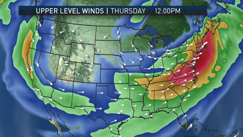
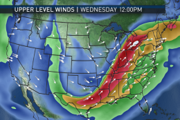
By the end of the week, the trough flattens and we start drying out behind a cold front. There will be quite a bit of contrast in temperatures in the U.S. on either side of the jet, so the wind speeds aloft will be quite strong.
(Data: Environmental Modeling Center, NOAA/Graphics: Storm Team 4)
Data: Environmental Modeling Center, NOAA/Graphics: Storm Team 4
A lot of west to east flights this week will have a nice tail wind (and vice-versa heading west).
(Data: Environmental Modeling Center, NOAA/Graphics: Storm Team 4)
Data: Environmental Modeling Center, NOAA/Graphics: Storm Team 4
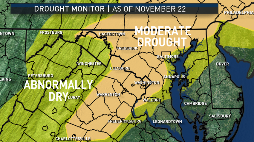
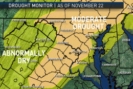
Lastly, an update on the drought situation. Most of the area is now in the “Moderate Drought” category in the national “Drought Monitor,” mostly for the shortages of the past six months (“Short Term”). But “Long Term” effects are starting to show up, so the rainfall that’s on the way is definitely very much needed. As of the Sunday afternoon update from the National Weather Service for Reagan National Airport: It had a rainfall/snowmelt total for the year of only 28.59 inches. That is a deficit of 7.78 inches. Of that deficit, 6.31 inches of it is from since Sept. 1 alone, and 2.59 inches of that is for just this month. This is why this is mainly a topsoil drought right now, but we’re right on the cusp of the longer-term impacts like groundwater and streams/creeks/rivers.
(Data: National Drought Mitigation Center/Graphics: Storm Team 4)
Data: National Drought Mitigation Center/Graphics: Storm Team 4
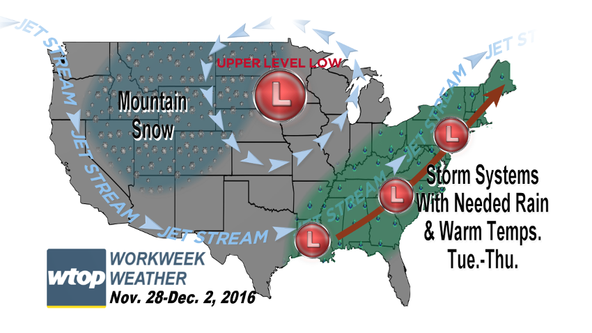
WASHINGTON — One of the tools of the forecasting trade is to be a pessimist when in a drought.
In fact, meteorologists have a saying: “When in drought, leave it out.” Dry weather can perpetuate its own weather patterns and we often have to wait for a large scale pattern change to overwhelm the dry local conditions. But that’s exactly what appears to be on the way for the new workweek.
The greater WTOP listening area will have several chances for some needed rainfall. We are not going to erase the entire rainfall/snowmelt deficit for this year (and the deficit technically also goes back into last year), but it is definitely going to help in the short term, benefiting the topsoil and mitigating the dry brush situation we’ve had that has led to the recent brush fires.
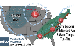
As very cold air will be on the move in central Canada, the jet stream steering winds will carve a deep trough (or dip) in the middle of the country with an upper-level low forming in the middle, and this trough will steer energy into the deep South, eventually forming several waves of low pressure at the surface, picking up moisture from the Gulf of Mexico and sending it our way. Along with this pattern will be a deep fetch of warm air from the southern Gulf of Mexico.
While it’s raining, we will have some above average temperatures along with some above average humidity levels, demonstrated by very high dew point temperatures for this time of year. The high humidity is directly correlated to the high chances for rain. The largest windows of opportunity for the rain to be falling will be Monday night through Tuesday afternoon, then again Wednesday night through Thursday afternoon.
After Thursday, the pattern will shift a bit, the trough will flatten out and we will lose our tap of Gulf of Mexico moisture and warmth. A cold front at the surface will end the rain Thursday night and cooler, drier, more seasonably chilly air will work its way in on Friday, lasting through the upcoming weekend.
When all is said and done, the area will be measuring over an inch of rain, at least. If everything lines up perfectly, we could be looking at 2 to 3 inches of rainfall total for the week. That would cut the year’s deficit by about half — beneficial for sure, but we could use even more. The official drought has expanded in area and in impact to the point that waterways and wells are starting to get affected; in other words, it’s not just a “short-term” drought anymore, but evolving into a long-term one.
Daily weather highlights
MONDAY
• Sunshine fading behind increasing clouds
• Average high temperatures, so not as cool as over the weekend
TUESDAY
• Periods of rain
• Breezy, very mild; starting to feel humid
• Rain ending in the afternoon
WEDNESDAY
• Morning lows higher than average daytime highs for late November
• Very warm and very muggy, almost balmy by November standards
• More rain arriving during the day
FRIDAY
• Mostly sunny, brisk and breezy
• Much more seasonable high temperatures
Editor’s Note: The WTOP Workweek Weather Blog is intended as an in-depth yet plain language summary of the business week’s weather potential in the D.C. area along with an explanation of the contingencies and uncertainties that exist at the time of publication. For the latest actual Storm Team 4 forecast, check out the main WTOP Weather Page.