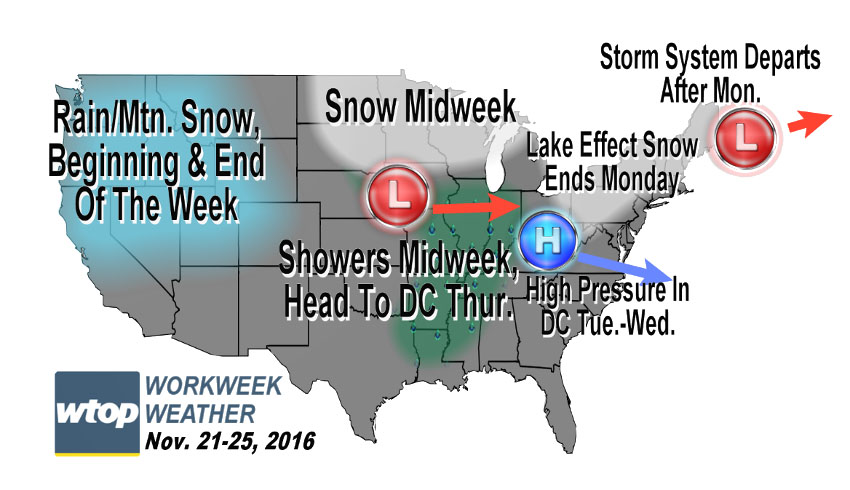
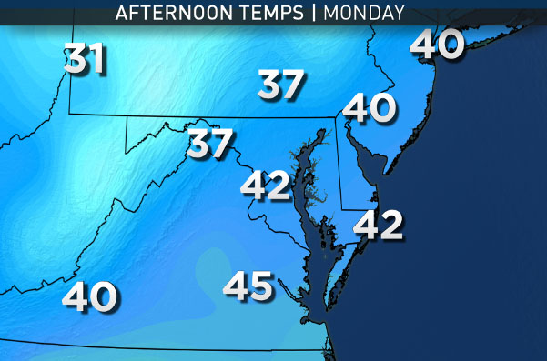
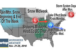
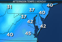

WASHINGTON — The shortened workweek for many starts off with more of the strong winds from over the weekend as deep low pressure will still be centered over New England and high pressure will be in the middle of the country.
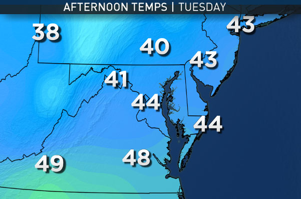
The contrast in pressures won’t be as profound as it was on Sunday, so the winds won’t be as damaging. Think of it as a regular, more typical type of windy day. But temperatures will again be well below average since the air is flowing here from central Canada on these northwest winds, and it will be blustery and cold. As the center of the high pressure system gets closer on Monday night, winds will diminish. With clear skies, dry air, and calm air, it will dip below freezing for Tuesday morning just about everywhere. Then, plenty of sun will be around Tuesday, but temperatures will still be below average.
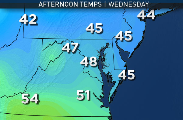
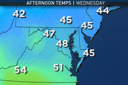
On Wednesday, the center of high pressure will begin to move offshore and the next storm system will be taking shape in the middle of the country. It will send a warm front this way and some increasing high level clouds during the day that will lower and thicken Wednesday night.
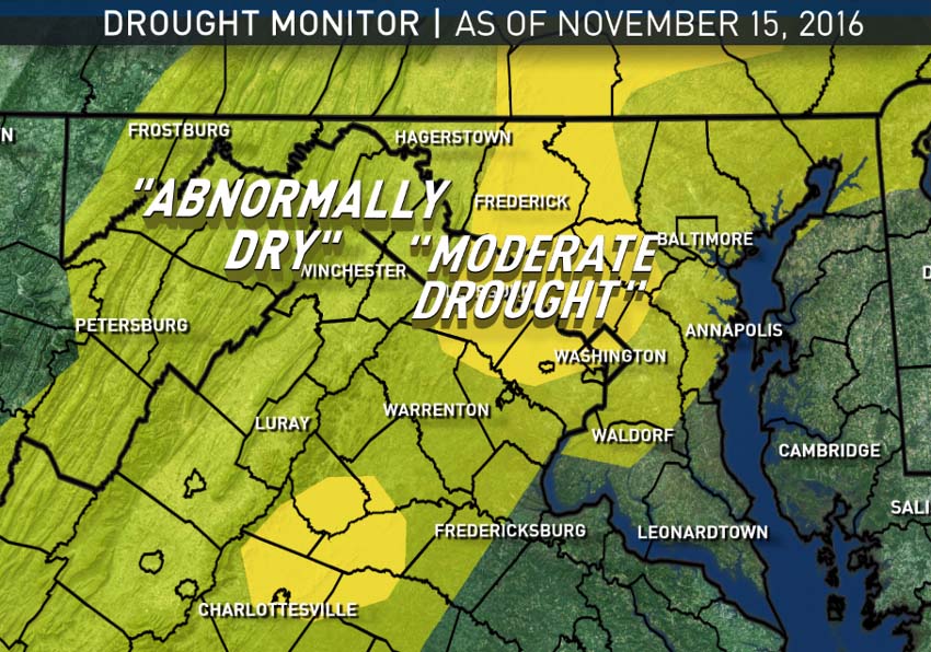
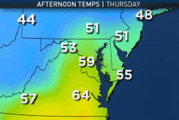
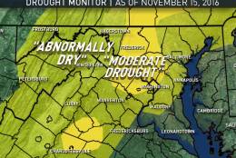
At this point, it looks like showers will arrive early Thanksgiving morning and depart quickly during the holiday, followed by clearing late in the day. Also at this point, it looks like rainfall amounts won’t be too heavy, which is great for travel concerns, but the area could use the rain, as drought conditions have officially worsened recently. At any rate, dry, breezy conditions will move in for Black Friday with chillier temperatures.
As of the Sunday afternoon daily climate report from the National Weather Service for Washington-Reagan National, the rainfall/snowmelt total for the year was 28.59 inches, which is 7.03 inches below average. Of that deficit, 5.56 inches of it is from since Sept. 1 alone, and 1.84 inches from this month.
As mentioned, drought conditions have expanded officially recently. A significant portion of the area is now considered in “Moderate Drought”, but luckily the impact is still topsoil and brush and not yet the groundwater or waterways. That would change, of course, if this predominantly dry weather the area has been having doesn’t change. The fire danger in these conditions has to also be mentioned.
Sunday’s potential for brushfires and wildfires will extend into Monday because of the dry brush, winds and very low relative humidity. Extra caution with outdoor burning is advised and throwing lit cigarettes out of car windows could be especially dangerous for starting fires under these conditions.
Daily weather highlights
Monday
- More sun than clouds, definitely more than Sunday
- Windy and cold, not as damaging as Sunday
- Brushfire danger
Tuesday
- Freezing morning
- Full sunshine
- Chilly but without much wind
Wednesday
- Chilly start with sunshine
- High level clouds
- More seasonable temperatures (upper 50s)
- In the evening: Becoming cloudy and cool
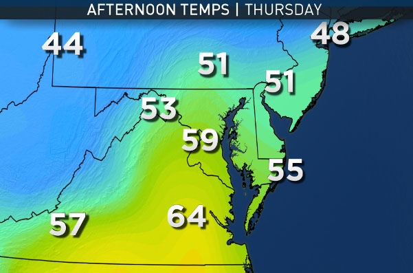
Thursday, Thanksgiving Day
- Cloudy with a few showers the first half of the day
- Clearing later in the afternoon and evening
- Somewhat mild (low 60s, depending on how soon sun comes out)
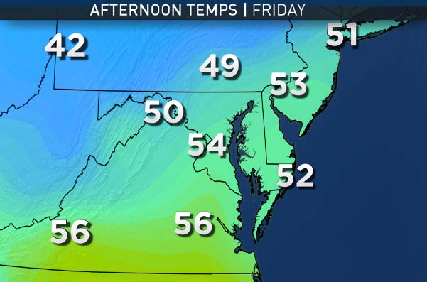
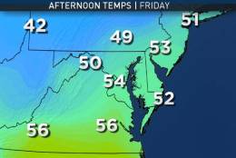
Friday
- Clouds and sun (sometimes mostly sunny, sometimes mostly cloudy is what we mean by that phrase)
- Breezy and chilly
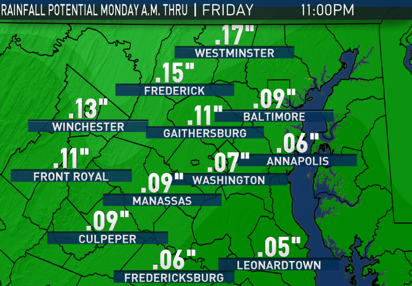
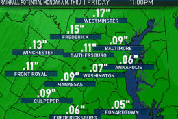
The “Moderate Drought” areas have expanded. And not much rain (or snow) is anticipated this week. The rainfall map is the untreated output from the GFS computer model for Monday morning through Friday evening. All the light amounts will fall Wednesday night and Thanksgiving morning.
The only other item to note this week will be some temperature fluctuations, starting out the week on the cold side, a spike on Thanksgiving Day, then ending on the chilly side on Friday. This data is also from the GFS computer model run on Sunday morning.
EDITOR’S NOTE: The WTOP Workweek Weather Blog is intended as an in-depth yet plain language summary of the business week’s weather potential in the Washington, D.C., area along with an explanation of the contingencies and uncertainties that exist at the time of publication. For the latest actual Storm Team 4 forecast, check out WTOP’S weather page.


