Workweek weather: Off to a soggy start Monday

(WTOP/Storm Team 4)
We will be starting the new workweek with rain already in progress on Monday morning. (WTOP/Storm Team 4)
This series of images show the output from the RPM computer model as of its run Sunday afternoon. It shows bands of showers and thunderstorms moving through from early morning through the afternoon. Some of the rain would be heavy or at least moderate at times. It tapers off late in the day and will be gone completely by Tuesday morning. The last image is the cumulative rainfall total from the same model run. Actual amounts will vary, but the scenario is that regardless, this will be beneficial rainfall for at least some of us. (Data: The Weather Company. Images: StormTeam 4)
This series of images show the output from the RPM computer model as of its run Sunday afternoon. It shows bands of showers and thunderstorms moving through from early morning through the afternoon. (Data: The Weather Company. Images: StormTeam 4)
This series of images show the output from the RPM computer model as of its run Sunday afternoon. It shows bands of showers and thunderstorms moving through from early morning through the afternoon. Some of the rain would be heavy or at least moderate at times. It tapers off late in the day and will be gone completely by Tuesday morning. The last image is the cumulative rainfall total from the same model run. Actual amounts will vary, but the scenario is that regardless, this will be beneficial rainfall for at least some of us. (Data: The Weather Company. Images: StormTeam 4)
Some of the rain would be heavy or at least moderate at times. (Data: The Weather Company. Images: StormTeam 4)
This series of images show the output from the RPM computer model as of its run Sunday afternoon. It shows bands of showers and thunderstorms moving through from early morning through the afternoon. Some of the rain would be heavy or at least moderate at times. It tapers off late in the day and will be gone completely by Tuesday morning. The last image is the cumulative rainfall total from the same model run. Actual amounts will vary, but the scenario is that regardless, this will be beneficial rainfall for at least some of us. (Data: The Weather Company. Images: StormTeam 4)
It tapers off late in the day and will be gone completely by Tuesday morning. (Data: The Weather Company. Images: StormTeam 4)
This series of images show the output from the RPM computer model as of its run Sunday afternoon. It shows bands of showers and thunderstorms moving through from early morning through the afternoon. Some of the rain would be heavy or at least moderate at times. It tapers off late in the day and will be gone completely by Tuesday morning. The last image is the cumulative rainfall total from the same model run. Actual amounts will vary, but the scenario is that regardless, this will be beneficial rainfall for at least some of us. (Data: The Weather Company. Images: StormTeam 4)
This last image is the cumulative rainfall total from the same model run. Actual amounts will vary, but the scenario is that regardless, this will be beneficial rainfall for at least some of us. (Data: The Weather Company. Images: StormTeam 4)
How will dew points fluctuate this week? Not much. The most comfortable day will be Wednesday. The rest of the week looks kind of muggy, but not oppressive.  (Storm Team 4)
How will dew points fluctuate this week? Not much. The most comfortable day will be Wednesday. The rest of the week looks kind of muggy, but not oppressive. (Storm Team 4)
Why so warm? The weather pattern shown by the jet stream winds has a flat ridge of high pressure over most of the country in the beginning of the week, before a trough (dip) of low pressure digs in the northwest, pumping up the ridge in the east a little more. The cold air is trapped in Canada until the trough develops out west. In this type of pattern, we would be even warmer at the end of the week, as has been discussed in our recent longer range forecasts. But if the clouds and more showers develop because of more “Julia” remnants, which are trapped underneath the ridge, then we will not be as hot as we would otherwise be. These graphics were produced by the American GFS Model from Sunday morning’s output. (Environmental Modeling Center/NOAA)
Why so warm? The weather pattern shown by the jet stream winds has a flat ridge of high pressure over most of the country in the beginning of the week before a trough (dip) of low pressure digs in the northwest, pumping up the ridge in the east a little more. The cold air is trapped in Canada until the trough develops out west. These graphics were produced by the American GFS Model from Sunday morning’s output. (Environmental Modeling Center/NOAA)
Why so warm? The weather pattern shown by the jet stream winds has a flat ridge of high pressure over most of the country in the beginning of the week, before a trough (dip) of low pressure digs in the northwest, pumping up the ridge in the east a little more. The cold air is trapped in Canada until the trough develops out west. In this type of pattern, we would be even warmer at the end of the week, as has been discussed in our recent longer range forecasts. But if the clouds and more showers develop because of more “Julia” remnants, which are trapped underneath the ridge, then we will not be as hot as we would otherwise be. These graphics were produced by the American GFS Model from Sunday morning’s output. (Environmental Modeling Center/NOAA)
In this type of pattern, we would be even warmer at the end of the week as has been discussed in our recent longer range forecasts. But if the clouds and more showers develop because of more “Julia” remnants, which are trapped underneath the ridge, then we will not be as hot as we would otherwise be. These graphics were produced by the American GFS Model from Sunday morning’s output. (Environmental Modeling Center/NOAA)
(1/8)
(WTOP/Storm Team 4)
This series of images show the output from the RPM computer model as of its run Sunday afternoon. It shows bands of showers and thunderstorms moving through from early morning through the afternoon. Some of the rain would be heavy or at least moderate at times. It tapers off late in the day and will be gone completely by Tuesday morning. The last image is the cumulative rainfall total from the same model run. Actual amounts will vary, but the scenario is that regardless, this will be beneficial rainfall for at least some of us. (Data: The Weather Company. Images: StormTeam 4)
How will dew points fluctuate this week? Not much. The most comfortable day will be Wednesday. The rest of the week looks kind of muggy, but not oppressive.  (Storm Team 4)
Why so warm? The weather pattern shown by the jet stream winds has a flat ridge of high pressure over most of the country in the beginning of the week, before a trough (dip) of low pressure digs in the northwest, pumping up the ridge in the east a little more. The cold air is trapped in Canada until the trough develops out west. In this type of pattern, we would be even warmer at the end of the week, as has been discussed in our recent longer range forecasts. But if the clouds and more showers develop because of more “Julia” remnants, which are trapped underneath the ridge, then we will not be as hot as we would otherwise be. These graphics were produced by the American GFS Model from Sunday morning’s output. (Environmental Modeling Center/NOAA)

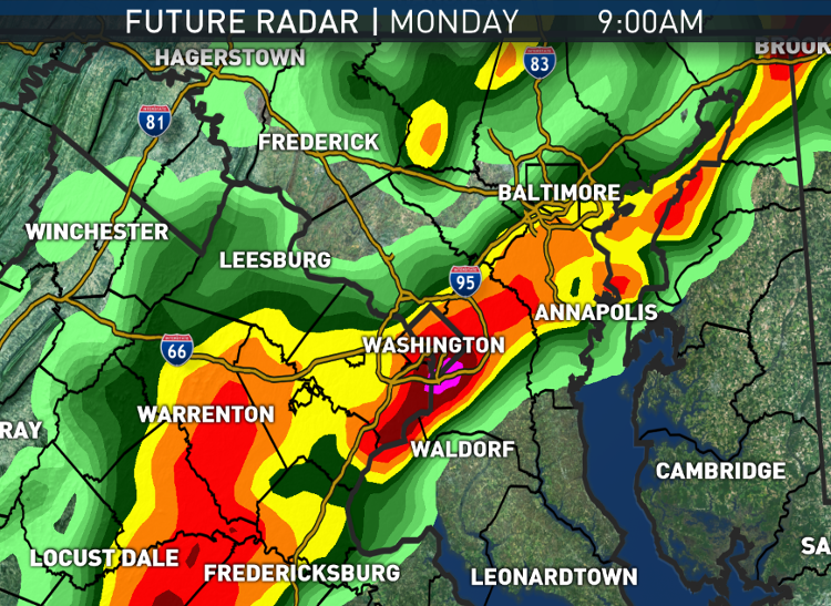
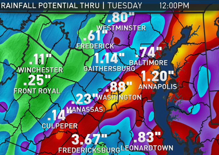
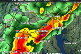
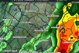
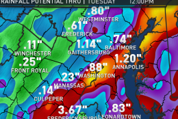
WASHINGTON — We will be starting the new workweek with rain already in progress on Monday morning.

The winds aloft ahead of a weak cold front will be tapping some tropical moisture loosely associated with Tropical Depression Julia and providing a lot of lift to the atmosphere, so some of the rainfall amounts will be very beneficial.  It has been a while since there has been a soaking rain, so there will be a lot of oil buildup on the roads and adding moisture to them will make them kind of slippery. That’s one of those weird-but-true things to keep in mind while taking some of those turns and curves, especially on the Capital Beltway.

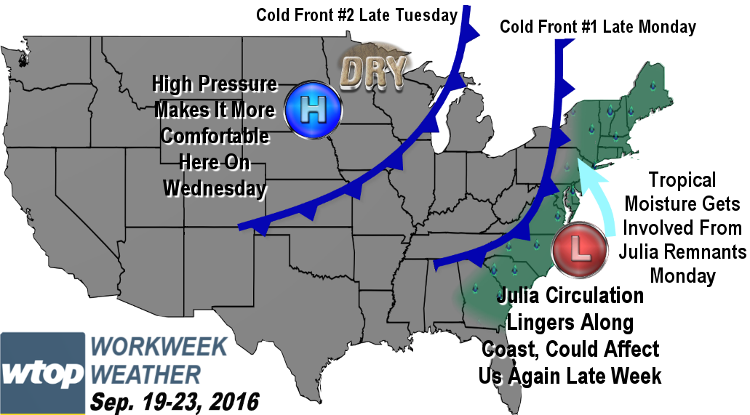
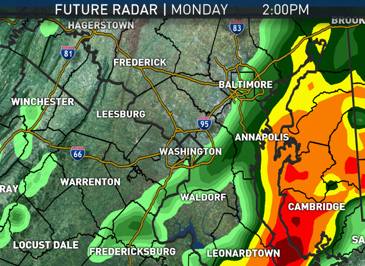
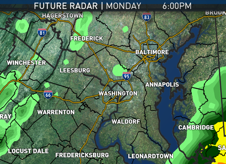
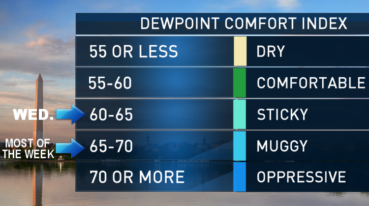
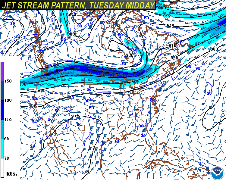
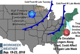
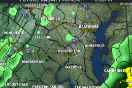
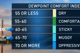
At this point, it looks like the rain bands will be tapering off slowly by the end of the day. It may be cutting it kind of close for the important Red Sox/Orioles series that starts Monday evening in Baltimore. But all the rain will end for sure Monday night as the first of two cold fronts for the week moves through. As it’s not a particularly strong front. It will still feel kind of sticky on Tuesday but maybe not as muggy as Monday. Another cold front will pass through on Tuesday but without any precipitation. High pressure behind that front will build in for Wednesday, bringing us sunshine and less humid air. Some spots will be rather comfortable, especially in northern Maryland. And the rest of the week looks like it will be unseasonably warm but quiet with a gradual increase in humidity again.

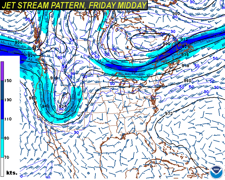
Now, it was mentioned that Monday’s rainfall will be sort of associated with remains of “Julia.” The circulation of that storm looks like it will remain just to our south, near Hampton Roads in Virginia and coastal North Carolina all week. There are two possibilities: It will just fizzle out in place by midweek or (more likely), another little batch of clouds and light showers could move back north for late Thursday into Friday. That would have an effect on temperatures, keeping us cooler than we otherwise would be under this type of weather pattern, with the jet stream well north into Canada and cooler air plunging into the northwest United States. So there are some uncertainties to fine tune after Wednesday.

In the meantime, many of us will enjoy the welcome rainfall on Monday. As of Sunday evening’s climate report, Reagan National had a rainfall deficit for the year of 3.57 inches, and 2.10 inches of that deficit comes from the lack of rainfall this month alone. A few tenths of an inch or even an inch certainly will help us out.

Daily weather highlights

Monday:

  • Slow commute due to wet roadways
  • Bands of showers and even some thunderstorms on and off through the day
  • Bands moving repetitively over some of the same areas, so some get more rain than other nearby communities
  • Temperatures close to average, but a real tropical feel to the atmosphere

Tuesday:

  • Showers have ended, but day starts with patchy fog and lots of clouds
  • Peeks of sunshine through mostly cloudy skies
  • Temperatures above average again; humidity only down a few notches

Wednesday:

  • Starts out mostly clear
  • Fair amount of sunshine before clouds increase late in the day
  • Humidity back down to the lower end of the sticky ranges, so not fantastically comfortable, but a comparative improvement

Thursday & Friday:

  • Either partly sunny or completely overcast, depending on the track of the last remnants of Julia
  • As result of sunshine and showers “wildcards”, either just seasonably warm or very warm and humid

Editor’s note: The WTOP Workweek Weather Blog is intended as an in-depth yet plain language summary of the business week’s weather potential in the D.C. area along with an explanation of the contingencies and uncertainties that exist at the time of publication. For the latest actual Storm Team 4 Forecast, check out the WTOP Weather Page.

Federal News Network Logo
Log in to your WTOP account for notifications and alerts customized for you.

Sign up