Workweek weather: Will ‘Bonnie’ bring chance for more showers?

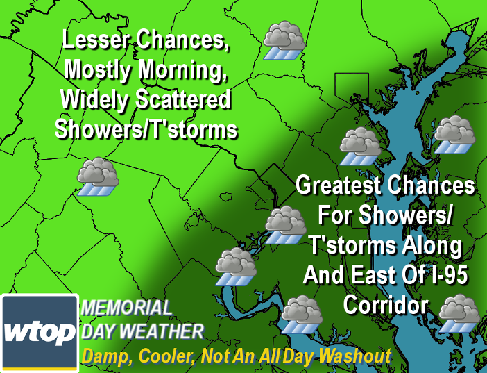
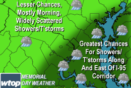
On Monday, Memorial Day, we will be dealing with chances for showers associated with Tropical Depression Bonnie.  (WTOP/StormTeam 4)
On Monday, Memorial Day, we will be dealing with chances for showers associated with Tropical Depression Bonnie. (WTOP/StormTeam 4)
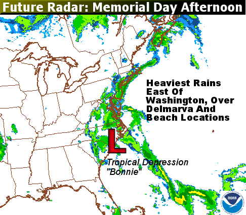
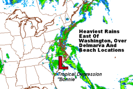
This is a simulation of what the regional radar may look like Monday afternoon from the North American Mesoscale (NAM) model which was run on Sunday afternoon. Note that most of the soaking rains would be mainly east of D.C., while everything else is “blotchy” and scattered. So the day is not a total washout. (Environmental Modeling Center/NOAA)
This is a simulation of what the regional radar may look like Monday afternoon from the North American Mesoscale (NAM) model, which was run on Sunday afternoon. Note that most of the soaking rains would be mainly east of D.C., while everything else is “blotchy” and scattered. The day is not a total washout. (Environmental Modeling Center/NOAA)
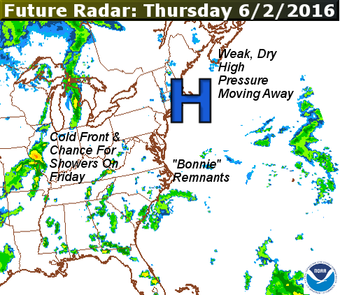
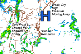
This graphic shows future radar for Thursday, as far out as that particular model goes. The broken line of showers in the Midwest is along the next cold front to pass through here on Friday. (Environmental Modeling Center/NOAA)
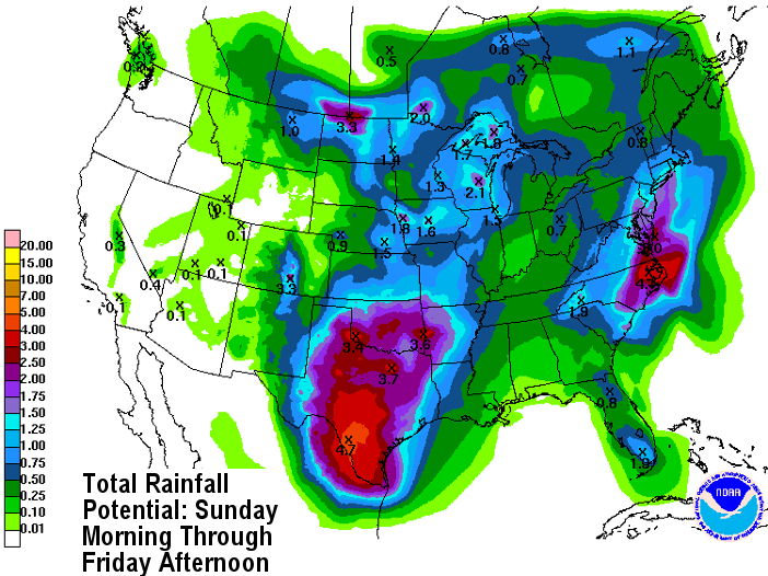
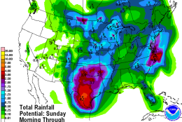
This image is the Weather Prediction Center’s forecast for rainfall for the whole country. It was issued on Sunday, so some of this rain may have already fallen by publication time. It’s valid through Friday afternoon. It certainly shows the influence of Tropical Depression Bonnie on our weather in the beginning of the week, some of us getting soaking rains. Again, note the higher amounts end up being east of D.C. Unfortunately, it means more potential problems for flooded Texas, too. The very slow moving cold front in the middle of the country is the source of the higher amounts in the Plains states. (Weather Prediction Center/NOAA)
(1/4)
On Monday, Memorial Day, we will be dealing with chances for showers associated with Tropical Depression Bonnie.  (WTOP/StormTeam 4)
This is a simulation of what the regional radar may look like Monday afternoon from the North American Mesoscale (NAM) model which was run on Sunday afternoon. Note that most of the soaking rains would be mainly east of D.C., while everything else is “blotchy” and scattered. So the day is not a total washout. (Environmental Modeling Center/NOAA)
This graphic shows future radar for Thursday, as far out as that particular model goes. The broken line of showers in the Midwest is along the next cold front to pass through here on Friday. (Environmental Modeling Center/NOAA)
This image is the Weather Prediction Center’s forecast for rainfall for the whole country. It was issued on Sunday, so some of this rain may have already fallen by publication time. It’s valid through Friday afternoon. It certainly shows the influence of Tropical Depression Bonnie on our weather in the beginning of the week, some of us getting soaking rains. Again, note the higher amounts end up being east of D.C. Unfortunately, it means more potential problems for flooded Texas, too. The very slow moving cold front in the middle of the country is the source of the higher amounts in the Plains states. (Weather Prediction Center/NOAA)

WASHINGTON — It’s an abbreviated work week because of the Memorial Day holiday, and for the most part it will be a quiet week. But on Monday, we will be dealing with chances for showers associated with Tropical Depression Bonnie.

On Sunday, moisture associated with the system, combined with some additional moisture transported in off the ocean and the bay, arrived in the form of some heavy showers and scattered thunderstorms.

That scenario will continue Monday. However, the moisture of the showers will be shifted to the east of the area, so not all of us will get showers. It does not look like a washout.

Because we’re talking about tropical remnants in an environment without a lot of a “steering flow,” the computer models are having some difficulty with timing the showers and also how much rainfall will occur. But in narrowing the most likely probabilities, Storm Team 4 believes the heaviest rainfall rates and coverage of area will be finished by morning.

In the afternoon, the focus will mostly shift to the area along and east of the Interstate 95 corridor. It will likely rain most of the day on the Delmarva Peninsula, including the beaches, and will be much cooler there with a stiff sea breeze coming off the cool surf. In the western suburbs near the Interstate 81 corridor, some late afternoon pop-up thunderstorms will be possible, but only scattered at most.

A weak cold front will move through the area Monday night and early Tuesday, shifting a lot of the moisture out to sea. The amount of moisture in the air will also be dropping a bit, so it will start feeling a little less humid, although it’s just a small difference. Instead of feeling muggy or oppressive, it will just be dropping to a level where it feels kind of sticky. The circulation and remnants of what’s left of “Bonnie” will still be lingering near the North Carolina coast, so we still may see some clouds associated with it. But Tuesday and Wednesday look to be precipitation-free.

Another cold front will start passing through on Friday, which will be the next chance for showers and thunderstorms.

Daily weather highlights

Monday:

  • Early morning showers leftover from Sunday night
  • Lull in the showers
  • More showers possible especially in eastern sections through the afternoon and evening
  • Isolated thunderstorms possible along the Blue Ridge in the afternoon
  • Cooler but just more seasonable temperatures compared to Saturday and Sunday

Tuesday:

  • Some morning clouds and possible patchy fog
  • Skies become partly if not mostly sunny during afternoon
  • Dropping humidity during the day but not a drastic change

Wednesday:

  • Looks like best day of the week as of this blog’s posting, but that could change because of more cloud cover

Thursday:

  • More cloud cover definitely on the increase ahead of next cold front

Friday:

  • Cold front passage brings more showers and thunderstorms

EDITOR’s NOTE: The WTOP Workweek Weather Blog is intended as an in-depth yet plain language summary of the business week’s weather potential in the D.C., area along with an explanation of the contingencies and uncertainties. For the latest actual Storm Team 4 Forecast, check out the main WTOP Weather Page

Federal News Network Logo
Log in to your WTOP account for notifications and alerts customized for you.

Sign up