Editor’s Note: This article is intended as an in-depth but plain language discussion for the Washington area’s weather factors, ingredients, and the uncertainties involved. For the latest Storm Team 4 Forecast details, check out the main WTOP Weather Page.
WASHINGTON — The blocked weather pattern we talked about last week evolved right on schedule and allowed for the showers we received on Friday and Saturday morning. The weather systems this week will move right along in the steering winds aloft (the jet stream).
This will provide a few more chances for some so-called “April showers” before the month ends. (Putting the term in quotes since there hasn’t been much rain).
The first system will be a wave of low pressure riding a slow-moving cold front coming down from Canada. That will affect us Tuesday and Tuesday night. The second will be a wave of low pressure riding the same front after it stalls to the south. That will affect us Thursday and Thursday night, and possibly Friday morning as well.
Both of these systems look like they will have their best energy and available moisture in the nation’s midsection, wrapping around into the northern Rocky Mountains. With their weakening trend before they get here, and with the already established dry conditions here, we are not optimistic that these will be deficit-busting rainstorms. But they will have the potential to at least keep the topsoil from drying even more, and they will help to reduce the very high pollen count a bit.
Of course, the Washington Nationals have a homestand again. The Phillies are in town midweek. These systems could affect Tuesday and Thursday’s game somewhat, but they’re not looking like washouts yet. The Orioles are back home Thursday against the White Sox, and that game could be affected as well.
Both of these systems will involve a frontal boundary that will be meandering around the listening area. Since we do live in a mid-latitude region, this is not uncommon in spring. But it does mean there is a potential for big temperature differences from the Pennsylvania state line all the way to southern Maryland, with D.C. and most of Virginia in between. So temperature-wise, as with the weather itself, the actual forecast is “unsettled.”
At least for the D.C.-metro area, the temperatures on Tuesday look much warmer with showers and even some possible thunderstorms. But on Thursday, temperatures look like the will be cooler by comparison.
DAILY WEATHER HIGHLIGHTS:
Monday:
- High level clouds build during the day
- Not as much deep blue sky
- Southwesterly winds really help temperatures warm
Tuesday:
- Overcast skies
- Showers are scattered, so it doesn’t rain all day
- Some showers could be thunderstorms, especially in the afternoon when cold front moves through
- Washington Nationals will have to keep an eye to the sky
Wednesday:
- Showers could linger into the morning, especially south of D.C.
- Cooler temperatures everywhere on northerly winds
Thursday:
- Front returns north, but how far through the listening area is uncertain
- Some spots south of D.C. could be much warmer than points north
- Better chance for showers than Tuesday’s system
- Still not a big, soaking rainstorm
Friday:
- Showers still in the vicinity
- Front likely pushed south again, so cooler temperatures return for everyone
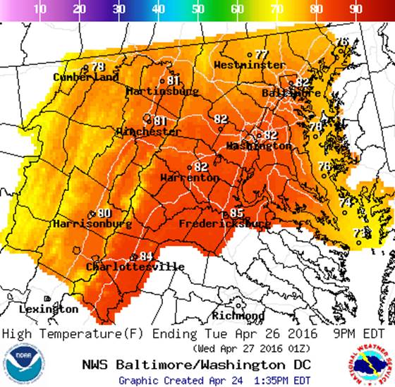
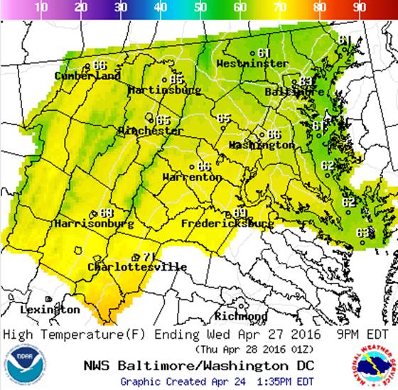
In the following graphics, we see the most likely contrast in temperatures between Tuesday and Wednesday. On Wednesday, the cold front will be just south of our area where it will stall out and drift back north for Thursday.
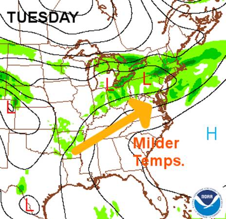
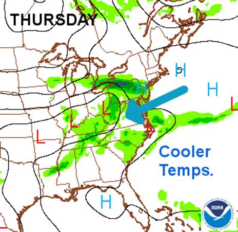
These graphics show the computer-forecasted areas of precipitation from the American Model (GFS) effective for Tuesday and Thursday afternoons. On Tuesday, we will most likely have southwesterly winds before the front gets here, keeping it quite warm. On Thursday, the front will likely be stalled to the south and we’ll have northeasterly winds. This cooler scenario, however, increases our chance of getting some better rainfall amounts. It would provide a better “wedge” to force up the Gulf of Mexico moisture-laden air.
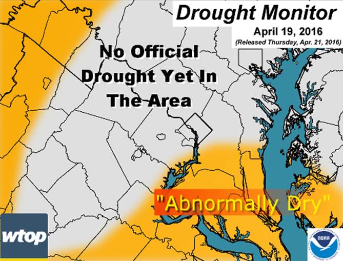
Now, we have been talking a lot lately about the rainfall deficit, mostly because March and April have been unusually dry. Officially, there is no drought yet in the WTOP listening area because the dry recent pattern has mostly impacted just topsoil and brush (the wildfire dangers we’ve had on dry, windy days). As of right now, the United States Drought Monitor (a product of many different agencies) does have some of our area in the “Abnormally Dry” category, mainly Southern Maryland and the Shenandoah Valley into West Virginia. So, for now, conditions will continue to be monitored to see if actual drought conditions develop. The latest Drought Monitor data zoomed into our area is in the graphic below. On a small scale basis, some conditions can vary.
As of Sunday evening, the rainfall deficit for April at Reagan National Airport is 1.03 inches. Since March 1st the deficit is 3.35 inches. For the year (rainfall and snow melt) the deficit is 2.31 inches.