WASHINGTON — The new workweek looks an awful lot like last week, but with a cool, damp start to Monday and our storm system departing to New England just a little bit later.
So we’ll have wet weather lingering through the Monday-morning rush; then a cold front will swing through, drying us out and bringing back more sun.
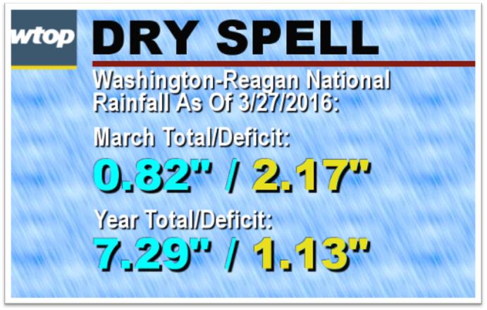
Any wet weather will help us out, since we’ve been fairly dry recently, but the rains of Sunday night and Monday morning won’t be enough to get rid of our deficit. High pressure will build in for midweek with moderating temperatures, just like what happened last week. That will keep the next storm system blocked for a few days in the Rockies, bringing them valley rains and mountain snows. The jet stream will steer that storm system up into the Great Lakes, keeping us on the warm side of it. It’s also our next chance for “decent” rainfall amounts.
Bands of showers will move up from the Gulf of Mexico starting on Thursday and lasting into Friday. If everything holds together, this system would make a dent in our rainfall deficit; however, if too much energy stays too far to our north, we won’t wring enough moisture out of the atmosphere and the system won’t do us any big favors.
So far, the rainfall deficit is just what’s called a “topsoil drought.” There have been several days recently when there’s been danger for brush fires, and there have been some actual fires. The danger has been highest when it’s been windy and when the relative humidifies have been very low. But the groundwater and the reservoirs have not been too affected yet by the dry month of March.
Note that the deficit for the year is not that large yet, and it’s mostly due to this month. But if the dry spell continues through most of spring, it could lead to drought problems by summer.
Early indications are for cooler-than-average temperatures in the beginning of April, but that may correlate into increased rain chances as well. We may have to give a little to get a little.
Highlights of the days ahead:
MONDAY: An area of low pressure moves up the coast and cold front moves through midday.
- Morning rain and drizzle end;
- Dry air starts clearing us out during the afternoon;
- Winds become quite gusty.
TUESDAY AND WEDNESDAY: High pressure builds to our south and sets up westerly flow, keeping it dry but warming it up.
- Sunshine both days, especially Tuesday;
- A little warmer than average each day.
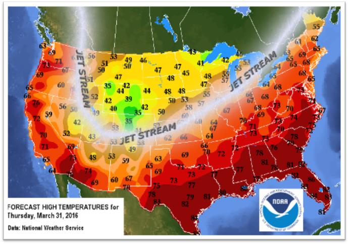
THURSDAY: Broad southwesterly winds ahead of a storm system make it the warmest day of the week.
- Highs could easily get into the low 70s the longer the clouds hold off;
- Showers arriving possibly as early as the evening rush hour.
FRIDAY: Cold front slowly moves through area with showers and storms. The slower the front, the heavier the rain.
- Storm system right on top of us, with limited sunshine;
- Not as warm everywhere throughout the listening area, depending on position of the front;
- Showers throughout the day;
- In spots that stay warmer, some thunderstorms will be possible.
The latest StormTeam 4 forecast details can be found on the main WTOP Weather Page.