WASHINGTON — A good soaking of rain that is taking up much of the eastern third of the United States is marching toward the D.C. region, so get that rain gear ready.
THE SET UP IN THE ATMOSPHERE
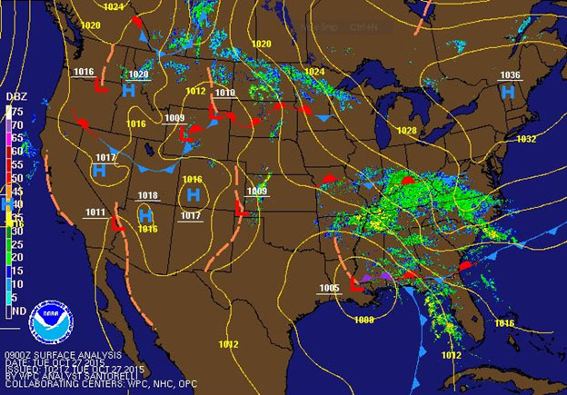
After a chilly day on Monday, Tuesday will be even cooler with clouds in place and rain on the way. A strong area of high pressure is sitting north over New England, providing a moist and cool easterly flow coming off the Atlantic. An area of low pressure — with moisture from the remnants of Hurricane Patricia along for the ride — is trekking out of the Gulf Coast and moving north, into Central Mississippi valley this evening, into western Kentucky at around midnight, and continuing on its journey towards the Great Lakes by Wednesday. This area of low pressure will strengthen as it makes its move north towards the Great Lakes by absorbing with another system moving out of the Plains and, in turn, bringing some wet weather through much of the Mid-Atlantic.
TIMING IT OUT FOR YOU
There is a lot of dry air over the WTOP listening area. As the rain moves in from the south and west and advances to the north and east, the moisture has to overcome that dry air. Eventually, the dry layer at the surface will erode, and we will start to experience rain hitting the ground. But the timing on that is difficult to forecast.
- Best bet is that areas southeast of D.C. (Central Shenandoah Valley, Culpeper, Fredericksburg, Fauquier County, Calvert and Charles Counties, etc.) will begin to see some raindrops from lunchtime to about 3 p.m.
- After about 2 or 3 p.m., rain will start to spread in the D.C.-metropolitan area through around 6 p.m.
- Areas to the north and east of D.C. (Baltimore, Anne Arundel, Eastern Shore, etc.) will be the last to see the rain move into the region, most likely after 5 or 6 p.m.
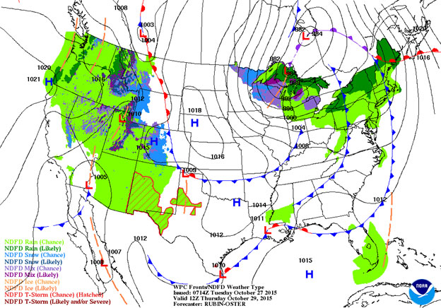
Rain will continue Wednesday, with periods of heavy rain and periods of more showery type of rain. Either way, expected it to come to an end by late Wednesday or early Thursday, overnight, as a cold front pushes through the region.
TEMPERATURES AND WINDS
Winds will begin to pick up Tuesday afternoon shifting from the northeast to the east. The region will start to see sustained winds across the WTOP listening area in the 15-20 mph range. The region will also experience gusts of up to 25 mph at times. This will continue through the overnight and through much of the day Wednesday. Rain will continue overnight as winds pick up out of the east. Temperatures will only top out in the 50s Tuesday, and that is where they will stay Tuesday night. However, by Wednesday, winds will shift to the southeast with the advancement of a warm front through the region — aiding the rise in temperatures Wednesday to near 70 degrees. Again, winds will continue to be fairly breezy Wednesday with gusts up to 25 mph at times, calming during the late evening.
Rain will continue through much of the day Wednesday, with periods of heavy rain and periods of a lighter rain. There is a chance the region could see an isolated thunderstorm here or there, given the temperatures by Wednesday afternoon, but the threat remains low.
RAIN ACCUMULATION
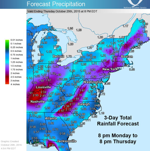
A good soaking of much needed rain is expected across the region; however, flooding is not expected to a concern because of the recent dry conditions. Thought, there could be some flooding in the low-lying areas and areas prone to flooding. Also, given the fact it is fall, there could be some drains that are clogged by leaf debris, so this is something forecasters will monitor, though it’s not expected to be widespread.
The current thinking is on par with 1 to 2 inches of rain through the region by the time this moves out of here early Thursday morning.
Once the rain threat is over on Thursday, the winds will stick around. Winds will now shift out of the west on Thursday at a 10-15 mph range, taking the temperature up to the lower 70s. High pressure builds in for Friday and Saturday bringing sunshine but cooler temperatures in the lower 60s.
Halloween and the trick-or-treating events look fantastic with clear conditions and temperatures in the 40s to around 50 in D.C. Also remember to set those clocks back before bed on Halloween. Daylight saving time ends Sunday morning. For perspective on that: Sunset on Tuesday is at 6:14 p.m.; by Monday, it is 5:07 p.m.