WASHINGTON – “You’re like the RG3 of the weather world, everyone loves you when you win but when you lose…”
This is what one of my witty friends wrote on my Facebook page after the blame game was well underway Tuesday afternoon from the early morning snow.
I personally have to admit that I was furious at the way meteorologists were getting thrown under the bus. I was so angry at the school officials/VDOT/the Internet/the fact that I had to walk 5 feet to fill up my water bottle. I was in contact with other meteorologists from around the D.C. region and from other media outlets ranting and raving along with them.
@islivingston i think it already did….. whomp whomp. Now we just need a professional football coach and we can call it a day
— Lauryn Ricketts (@laurynricketts) January 6, 2015
Truth be told, I have had a good 24 hours to think about it…and yes, here we go: We were wrong and by the time we saw what was coming through, decisions had been made and people were on the roads.
Honestly, I don’t know how or when schools systems make their decisions – obviously it is different in every district and no, I am not entirely up to speed on VDOT protocol. All I can account for is myself, and my forecast was off by a couple inches – and boy do those inches matter during a morning commute.
With that being said, we did harp on the fact that this would impact the morning commute. Check.
We did say the time that the snow would come through would be 4 a.m. to 10 a.m. Check. The morning commute in D.C. is generally from 5 a.m. to 10 a.m. and I don’t think I am dropping any big surprises when I say that ANYBODY who commutes in the D.C. area knows that we can barely drive in rain let alone snow.
However, we did not anticipate where a possible heavy band would set up; dropping a few more inches on us than initially called for, starting at 7 a.m. and lasting through 9 a.m. – prime morning drive time.
I drove into the station at about 5:15 a.m. At that time, I’ve got to tell you, the roads were already dreadful. My neighborhood was snow covered and Interstate 395 was a winter wonderland with fresh tracks of cars passed barely visible. It was slick at that time and I have 4-wheel drive.
As soon as I got into the station, I got together with all the early morning meteorologists to compare forecasts. While we were all on the same page initially, we all watched this heavy band form about an hour later. Before we could get snow totals of what was already on the ground, it was too late. This snow band was dropping heavy snow and it was dropping it quick. So much that I got this tweet before I could even have a chance to update my forecast:
Hey @laurynricketts @WTOP. Time to revise your snow ttls. ~4″ here in @GreatFalls pic.twitter.com/NyjL00myLI — andy bast (@agbast) January 6, 2015
Darn. I updated my forecast and at that time it was too late. People were already on the roads, on the way to school and already stuck. DMVer’s were upset at school officials, school officials were upset at meteorologists, meteorologists were upset at school officials (and honestly upset at this band of snow that dropped a few more inches on us). Everybody was playing the blame game.
@laurynricketts @ABC7News @AmericanU complete failure by the forecasters.
— Alex M. (@vamosCAPS) January 6, 2015
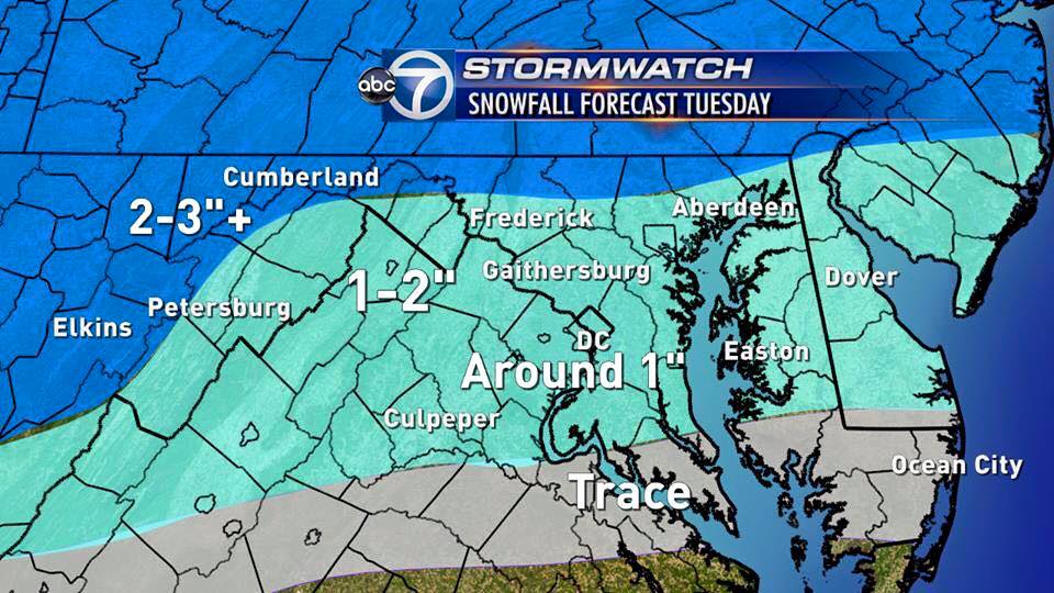
Now I can’t say that we busted the forecast. In fact, we were not off by much. Here is our snow total map from Monday night (usually we try to keep these as consistent as possible until there is 100 percent need to change and this is exactly why WJLA waits to post snow total maps until right before an event – because things change quickly):
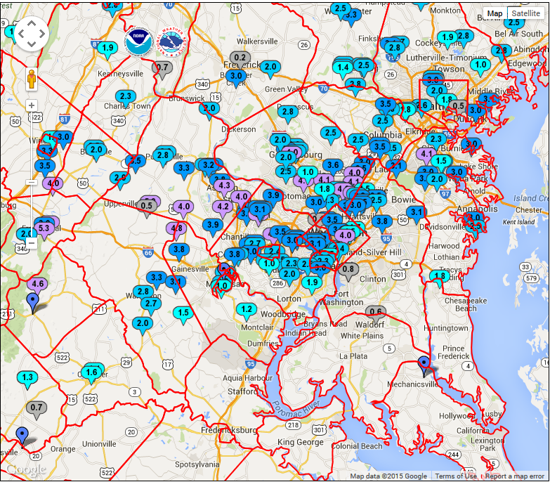
But considering this was during the morning rush, we might as well have been off by a foot of snow. Did we call for a dusting in Loudoun County? No. But we didn’t call for 3 to 5 inches either.
Although I was playing the blame game yesterday, I can’t in right conscience do that today. Our number one goal as meteorologists is safety, safety for those that look to us for accurate weather information and those who look to us for a more in-depth explanation of what is going on than what their phone app is telling them. Somewhere in this, we fell short.
Obviously we did not get the message across that this event, whether a small amount of snow or a few inches, would impact the morning travel as massively as it did.
Obviously there has to be a better way to communicate our concerns as meteorologists and scenarios that could happen with an ongoing forecast.
Obviously we are not relaying the fact that weather in these situations can change on a dime. Somewhere, information is getting lost in translation to school officials and transportation departments. (Note: to school officials/transportation departments – open invitation in the future to call us with any questions regarding the forecast and we will give you an honest opinion).
We are all in this together. I hate to say it, but we are not always going to get it right. And maybe the public schools won’t always make the correct decision and maybe there should have been more plows and maybe this and what if that…. We just have to take what we have learned from this storm and utilize those lessons for the next one. All in all, we need to take it as a whole, take responsibility, improve and move on to the next storm.
Follow @WTOP on Twitter and on Facebook.


