This video is no longer available.
What in the world was that odd, funnel-like cloud seen near the U.S. Capitol building during a round of thunderstorms in D.C. early on Tuesday afternoon?
Photos of the phenomenon quickly went viral on social media. To onlookers, it looked like a strand of hair, a worm, a tadpole, a curlicue — the precursor to a tornado, perhaps? In reality, not quite.
“It is not a tornado, it is not a twister,” WTOP traffic reporter and weather researcher Dave Dildine said.
The thunderstorm cloud it briefly dangled from lacked the meaningful storm-scale rotation that would signal a tornado was forming, Dildine said.
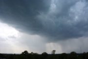
What it actually was, Dildine explained, was a mid-level funnel cloud.
“When storm-chasing, you see a lot of these around developing storms. They often only last a few seconds and are common when storms are developing vertically. Air swirls as it moves where it wants to go — whether it’s from volcanic vents, steam from the wet ground or ascending from the base of a towering thunderstorm,” Dildine said.
WTOP meteorologist Mike Stinneford added that the cloud was most likely a very localized area of rotation associated with a strong thunderstorm moving into the eastern District, past Capitol Hill.
“I am hearing that the funnel dissipated quickly, and there was never any danger of a tornado touching down,” Stinneford said.
Hey @capitalweather what’s this just seen over the Capitol dome?!?!? pic.twitter.com/w4DoHPbJFB
— Peter Kiley (@PDad) July 25, 2023
Dildine said that funnel clouds come in a range of shapes and sizes but the benign variation seen on Tuesday is not formed by the same process as a traditional tornado.
WTOP’s Emily Venezky contributed to this report.