While winter never showed up with much snow, spring isn’t proving beneficial in terms of bringing rain into the D.C. region — and it’s showing with stream and creek levels.
Reagan National Airport is 4.2 inches below average for rainfall this year, with half of that deficit racking up since the start of meteorological spring on March 1.
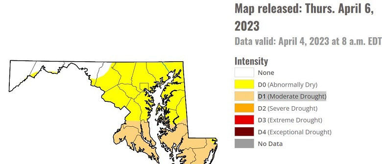
For much of the region, the year is off to an abnormally dry start, but as of late last week, southern Prince George’s, Calvert, Charles and St. Mary’s counties in Maryland were upgraded to moderate drought.
The U.S. Drought Monitor upgraded the southern suburbs to moderate drought due to short-term rainfall deficits reaching 3.5 to 4.6 inches as well as low streamflow and dry soil. As a matter of fact, streams from eastern Pennsylvania, through all of the D.C. area are running lower than average.
As an example, the stage of Seneca Creek at the Dawsonville location is 2.1 feet, and the second-lowest water level recorded at this spot is 1.30 feet on Aug. 1, 1974.
The persistent dry weather will allow the Potomac River at Georgetown to drop to 1.3 feet by April 12. The fifth-lowest water level recorded at this location is negative 2 feet on Sept. 19, 1936 (Yes, it’s possible for the lowest water level to be below 0 feet).
Moisture available in the top soil is running 2 to 2.5 inches below average.
This dryness, combined with warming temperatures this week and likely increasing winds from a few dry frontal systems that will pass by to our north, will increase the brush fire risk. The elevated fire risk will likely trigger the weather service to issue a Fire Weather Watch and upgrade to a Red Flag Warning.
Brush should not be burned on red flag days, and lighted cigarette butts should be properly discarded. Charcoal should be dunked in water until it’s cold, and live charcoal should never be thrown onto the ground.
Given the lack of widespread rain from last Thursday’s frontal system and a dry week ahead, it’s possible a moderate drought could be expanded into D.C. and west through Northern Virginia during the Drought Monitor’s next update this Thursday.
The latest trends support occasional rain this weekend into early next week from a southern low pressure teaming up with an approaching cold front, but it likely won’t be enough to pull the region out of a drought.
April is traditionally the driest month of spring, with an average of 3.21 inches of rain, while May is the third wettest month of the calendar year with 3.94 inches. The last time our southern suburbs were included in a moderate drought was mid October 2019.
The highest drought classification, exceptional drought, only occurred once in the southern suburbs, and that was in late summer 2002.